Last updated December 2019 | Words and photos by Vietnam Coracle
This post was last updated 4 years ago. Please check the comments section for possible updates, or read more on my Updates & Accuracy page.
INTRODUCTION | GUIDE | MAP | RELATED POSTS
The roads linking the three northern provinces of Ha Giang, Cao Bang and Bac Kan travel through some of the most spectacular and remote regions of Vietnam. The landscape around here is extraordinary: many travellers consider this their favourite place in Southeast Asia. Connecting two of the most scenic motorbike routes in the country (the Extreme North Loop and the Northeast Loop), a handful of incredible mountain roads corkscrew their way through a complex terrain of steep valleys, limestone karsts, and raging rivers. There are several different route options for riding between Ha Giang, Ba Be Lake (in Bac Kan Province), and Cao Bang; all of which are stunning, but none of which are particularly straightforward. In this guide, I’ve mapped three routes that connect the extreme north with the northeast.

Three spectacular (but unpredictable) routes lead over the mountains from Ha Giang to Cao Bang
[Back Top]
GUIDE: HA GIANG→BA BE→CAO BANG
ROAD TRIP DETAILS:
- Total Distance: 360km/370km/310km
- Duration: 1-3 days
- Route: three scenic routes linking Ha Giang with Ba Be Lake & Cao Bang [MAP]
- Road Conditions: back-roads & mountain highways, rough sections, light traffic
- Scenery: limestone karsts, mountains, deep valleys, jungle, terraced rice fields, minority villages
ROAD TRIP CONTENTS:
- CLASSIC ROUTE: Ha Giang→Meo Vac→Bao Lac→Cao Bang: 360km
- BORDER ROUTE: Ha Giang→Meo Vac→Bao Lac→Pac Bo→Cao Bang: 370km
- BA BE LAKE ROUTE: Ha Giang→Da Vi→Ba Be Lake→Cao Bang: 310km
ABOUT THESE ROUTES:
The map below shows three alternative routes between Ha Giang, Ba Be Lake, and Cao Bang. The Classic Route (the blue line) is the most popular and easiest to follow; the Border Route (the red line) is the most remote and least travelled; and the Ba Be Lake Route (the green line) is a combination of rarely used roads and national highways. The purple lines are connecting roads between the three routes, so you can mix and match as you please to create a route that suits you best. Although all of these routes are extremely scenic, they’re not necessarily easy to ride. The difficult, mountainous terrain, and frequent bad weather, mean that road conditions often deteriorate, resulting in treacherously muddy sections. What’s more, roadworks to upgrade and maintain these routes are ongoing. I’ve marked sections of rough road as best I can on my map. But, when riding any of these routes, take note of recent weather conditions (heavy rain, for example, can lead to serious landslides which can block roads for hours or even days), and try to ask locals or other riders you meet about current road conditions. Below, I’ve written a brief description of each route. For accommodation, there’s at least one mini-hotel or local guest house (nhà nghỉ) at each of the places marked with a red pin on my map. (For more details about accommodation in Ha Giang and Cao Bang see my Extreme North and Northeast guides.) Any time of year is good, but the heaviest rains occur during the summer months (June-August), and it can be bitterly cold during the winter months (December-February). Although any of these routes can be completed in one (long) day, the winding roads make riding a lot slower than you might expect. Alternatively, you can turn this into a scenic round trip by connecting the upper, lower, and middle routes and making a loop.

ROUTE MAP:
Ha Giang→Ba Be Lake→Cao Bang | 3 Routes
Blue line: 360km | Red line: 370km | Green line: 310km
View in a LARGER MAP
The Classic Route:
BLUE LINE: Ha Giang→Meo Vac→Bao Lac→Cao Bang: 360km [MAP]
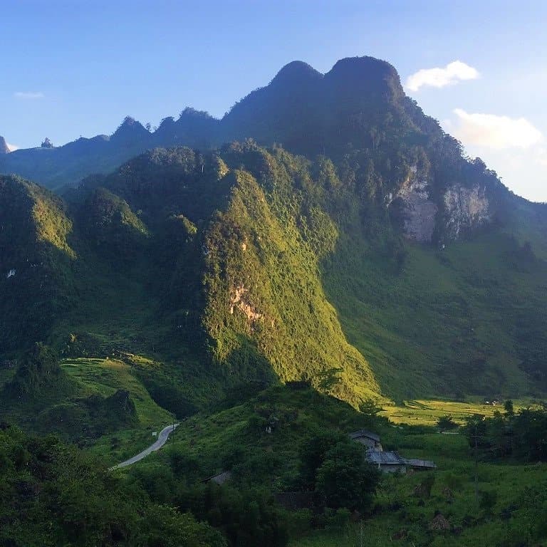
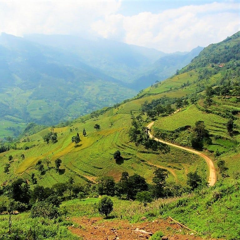
Starting out on the famous Ha Giang Extreme North Loop via the limestone landscapes of the Dong Van Karst Plateau, the Classic Route then heads southeast from Meo Vac on road QL4C down to the Gam River Valley. Out of Meo Vac there are some fabulous views over a vast and sparsely populated landscape. Although mostly upgraded, parts of the southern half of QL4C to the Ly Bon intersection with QL34 are still undergoing repairs. However, these should be finished by the time you read this. After crossing the bridge at Ly Bon, turn onto QL34 due east towards Bao Lac. Ly Bon is at the confluence of the Nho Que and Gam rivers, and the ride to Bao Lac affords some picturesque views of riverine scenes. However, there are currently (2019) major road works on the section of QL34 between Ly Bon and Bao Lac, so ride very carefully. Bao Lac has plenty of guest houses if you need them.

Road QL4C between Meo Vac & Bao Lac offers some extraordinary views over rice terraces & mountains
From Bao Lac, continue southeast all the way to Cao Bang city, via the mining town of Tinh Tuc and Nguyen Binh (both of which have a couple of nhà nghỉ guest houses). It’s a long ride to Cao Bang, and, although the scenery is superb (particularly around Tinh Tuc), the road conditions to Nguyen Binh are unpredictable. Expect a few rough patches, potholes and, if there’s been rain, landslides. Between Tinh Tuc and Nguyen Binh, there’s an intersection with a turning due south on road DT212 to Cho Ra: use this excellent back-road if you want to go to Ba Be Lake. If not, continue east along the meandering QL34 to Cao Bang City.

Road QL34 southeast from Bao Lac to Cao Bang has some rough patches but the scenery is excellent
The Border Route:
RED LINE: Ha Giang→Meo Vac→Bao Lac→Pac Bo→Cao Bang: 370km [MAP]
After following the Extreme North Loop from Ha Giang to Meo Vac, head southeast on road DT217 towards the famous ‘Love Market’ of Khau Vai (usually held in April). This meandering road soars over a limestone plateau before descending sharply through Khau Vai village and down to the banks of the Nho Que River. Road conditions deteriorate severely before crossing the river on a bamboo raft ferry and continuing the other side. From here, it’s a twisting ride over barren mountains (with incredible views) all the way down to Bao Lac in the Gam River Valley. The road surface is very inconsistent on this section, and it may prove challenging for riders on automatic motorbikes. Bao Lac has a few local guest houses if you need to stay the night.

Road DT217 winds up the hillside leaving Meo Vac & then heading southeast to Khau Vai & Bao Lac
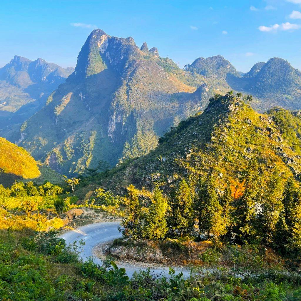
Follow the Gam River east of Bao Lac on an as yet unnamed road. This road is currently the talk of many riders in Vietnam. Hugging the Chinese border for much of its length, the road passes through some extremely remote landscapes. As if the fabulous scenery weren’t enough, the road itself is quite a sight. A narrow asphalt lane, it’s full of contortions and knots; constantly switching back on itself as it negotiates the difficult terrain. Just look at it on the map: it looks like the path of an agitated dragon, shifting violently from left to right, as if trying to shrug an assailant off its back. One pass in particular is breathtaking: Ascending what is essentially a vertical wall of rock, the road passes 14 (by my count) consecutive switchbacks. I call this the ‘Roller Coaster Pass‘, although it has recently been named đèo Mẻ Pia on Google Maps. And while we’re randomly namely things, let’s call this unnamed road the ‘Agitated Dragon’.

Looking down on one of the 14 switchbacks of the ‘Roller Coaster Pass’ on the ‘Agitated Dragon’ road
And so, the Agitated Dragon continues east along the Chinese border (with some extended rough, gravelly sections in the middle) until it hits the Ho Chi Minh Road (DT208), just south of Pac Bo Cave. (To visit the cave – which is well worth it – turn due north on road DT208 for 10km). Turn onto the Ho Chi Minh Road (DT208) and ride its smooth course south for 40km to Cao Bang city.

Pac Bo Cave on the Chinese border is a fascinating historical sight in a beautiful natural setting
The Ba Be Lake Route:
GREEN LINE: Ha Giang→Da Vi→Ba Be Lake→Cao Bang: 310km [MAP]
This southerly route between Ha Giang and Cao Bang, via Ba Be Lake, can be joined at any point along road QL34: you don’t necessarily have to begin it on QL34 right out of Ha Giang city (see the purple lines on my map for connecting roads with the green Ba Ba Lake route). This route comes in two halves: the first half passes through lovely landscape on QL34 along the Gam River Valley; the second half, from Ba Be to Cao Bang, is a smooth ride mostly on QL3 through fantastic mountainous landscape.

The southerly route between Ha Giang & Cao Bang, via Ba Be Lake, passes particularly lush scenery
Take QL34 east out of Ha Giang along the very pretty Gam River Valley. This section of road was in poor condition for years, but now (2019) is in much better shape. Eventually you’ll reach the intersection with road DT176 heading south to Da Vi. This is an isolated, beautiful road: a narrow paved lane slicing along valleys and over mountains. It’s a gorgeous ride in good weather, but again you will have to contend with some pretty awful road conditions. In dry weather it should be OK, but if there’s been heavy rain it’s likely to cause landslides and mud pools. Take a look at the photo below to get an idea of what I’m talking about. Having said that, the bad patches are short (but difficult), and if you have a decent bike, it shouldn’t be any problem.

Some sections of QL34 & DT176 can be very tricky conditions, but the bad patches are generally short
DT176 ends at the small village of Da Vi, on the edge of a giant reservoir. It’s a very off the beaten path place, but there’s a nhà nghỉ guest house here if you need it. From here, bear east onto an unnamed road leading over some spectacular mountains and through dense jungle all the way to the crossroads near Ba Be Lake. To go to the lake and the homestays on its southern shores, turn due west. Otherwise, take road QL279 east towards Cho Ra village, where there are several guest houses. From Cho Ra, it’s a lovely, lush ride to the intersection with QL3 at Na Phac. National Highway QL3 is a great road ploughing through marvellous scenery all the way to Cao Bang city.

Stay at one of the homestays on Ba Be Lake before continuing on the excellent road QL3 to Cao Bang
[Back Top]
Yesterday I drove the long and winding roads from Ha Giang to Ba Be Lake. No roadworks at all, no rough sections except for one 200 m long one in Ba Be Village. But be aware: There are not that many gas stations on the route. Sometimes there are 45 km between two stations.
Hi Frank,
Thank you for this update – it’s really great to hear that all the roads on that route are in good condition: great news!
Best,
Tom
Thank you so much for alle the work you have put into this website!
I wish to contribute a bit by giving an update on the roads I have just completed:
DT176 connecting the North with Da Vi is in perfect condition by now. It seems like the construction works have finished. I highly recommend this road because it is very lonely. Also, I recommend anyone going from Da Vi to Ba Be Lake to take a short cut: leave QL279 at Cao Thuong and turn right towards Dong Puong (Puong Cave). The road is in good condition and you will have a lovely ride through jungle, over a suspension bridge and a great view on Puong Cave.
Hi Josephine,
Thank you very much for this useful update – it is a great help to me and, I’m sure, to other riders.
Best,
Tom
Hello Tom and team!
Thank you so much for this article! Together with a friend we followed your itinerary and had an absolute blast!
Regarding the “unnamed road” or “the road of the agitated dragon”, on the way to there we passed in front of a signage that clarified the name of the 15 loop pass. It’s official name is “Khau Cốc Chà”! More-over at the time of riding it (November 2023) the whole 15 loops were a muddy and rocky construction site. Fun for sure.
Thanks again and keep riding and writing about Vietnam!
Best,
Hi Pierre,
Thanks. I’m glad to hear you enjoyed your ride.
Thanks for the update about Khau Cốc Chà pass – a couple of other readers have also mentioned that the pass is undergoing repairs – hopefully they will be finished sometime later this year.
Best,
Tom
Hello Tom, thanks for everything you’ve done with this site, it’s been an invaluable resource for a couple of my trips in Vietnam. I’ve just gotten back from taking a mixture of the routes mentioned here, I hope the following information can be of some help to your readers.
Day 1: Ha Giang to Yen Minh
Rented 3 XR150s from QT in Ha Giang. The shop is popular with renters, so do take note that choosing your bike and processing your paperwork can take quite awhile. The route is the blue one mentioned in the article. Pretty standard stuff in terms of riding and the roads, it’s the same one being taken by the big tour groups.
Day 2: Yen Minh to Dong Van
Followed the blue route once again, but with a detour to the Lung Cu flagpole. Great views as expected.
Day 3: Dong Van to Du Gia
The blue route once again, going through the Ma Pi Leng pass and detouring off to the boat ride at the Nho Que river, finally reaching Meo Vac. From Meo Vac, took the purple route to Du Gia. Large portions of the roads leading out of Meo Vac to Du Gia remain heavily under construction, so expect plenty of gravel, sand, rocks, and dusty roads. Eventually the roads get better, the last 15-20km into Du Gia was a nice ride.
Day 4: Du Gia to Bao Lac
Followed the purple route out of Du Gia to link back up with the QL34. As mentioned in the article, a fair bit of the road remains under construction and you will encounter similar road conditions as to the previous day’s journey from Meo Vac. Once back on the QL34 (green), road conditions are great and it was an easy and scenic ride over to Bao Lac. This also seemed to mark the start of the route getting off the main backpacker route and we didn’t see any more tour groups.
Interestingly whilst planning our journey, Google Maps routed us through a backroad starting off around Lung Ho and linking back up to the QL34. Compared to our taken route, this would have apparently saved about 30km. We contemplated this but decided against it eventually as we could not get any info about the route online nor would any of the locals we talked to recommend it.
Also, QT recommended us to stay off the purple route linking back up to the QL34 due to the road works. Even if you’re headed back to Ha Giang, they will recommend that you backtrack and take a detour. My take is that at the present time, the roads are in no worse condition than what you would have encountered from Meo Vac to Du Gia, save for the very initial stretch once you pass the scenic viewpoints coming out of Du Gia. You’ll have to ride over larger rocks and this portion lasted around 1km if my memory serves me correctly. The road workers initially signalled to us that we could not pass, but we soon saw bikes passing through as we pulled over and contemplated backtracking. Most of the time, the works do not actually stop for you to pass and it seems like you’re free to go as long as they do not explicitly stop you. Liberal horn usage is recommended.
Day 5: Bao Lac to Pac Bo
Took the red route, going over the Khau Coc Cha and Bong Nam passes. Google Maps may route a detour going around these passes, and we learned from our homestay that the Khau Coc Cha pass is under construction and closed on certain days. Thankfully, it was opened the day we visited and we rode through in conditions that by now, proved more of an annoyance than a hindrance. But do still exercise plenty of caution. After this, the road through to Pac Bo is an absolute delight. We passed through valleys surrounded by lush rice fields and many a smooth mountain road without another vehicle in sight.
At Pac Bo, we rode a mini-loop starting and ending from the gates to the Pac Bo complex. We headed south and turned off to the left where the ‘UBND Huyện Hà Quảng’ is. You’ll ride through some tranquil farming backroads and the road conditions are so-so.
Day 6: Pac Bo to Cao Bang
A short and easy ride over wide and good roads. We returned the bikes without a hitch.
All in all, a great adventure. The XR150 from QT was in good enough condition and held up well against the different types of terrain encountered on the journey. Our group encountered police checkpoints but did not get stopped at any of them, though this could have been because we could reasonably pass off as local. For what its worth, we all had prior experience with manual motorbikes and riding mountain roads in semi automatic/automatic bikes, but it was our first time riding manual motorbikes in the mountains.
Thanks again Tom for the article!
Hi Daryl,
Thanks for your trip report and road updates – it is very helpful and useful to me and other readers/riders. I appreciate it.
There are so many roads and alternative routes now in Ha Giang that you can make a number of different loops. Conditions get better each year.
Yes, Ha Giang is now a popular stop on the backpacker trail. But Cao Bang, Lang Son and Bac Kan in the northeast remain mostly off the beaten path.
Best,
Tom
Many thanks for the report Daryl, very complete. I´d like to ask you or Tom if you know any reliable source to ask about which days is open the Khau Coc Cha pass. We are planing to go in a couple of weeks and it would be very helpful to know this info to plan our trip as we don´t have a lot of time. The alternative is to ask on-site to our homestay but the problem is if we are unlucky and the road is closed the day we want to take it. P.S Thanks for the blog Tom, the info you provide here is amazing. I used the blog 8 years ago in a one-month trip solo and I am happy to be back and follow your advice again
Hi Lucas,
Thanks for your kind words.
I think the best option is to ask when you get there – preferably the night before you plan to ride the pass at your accommodation. No doubt it will depend on changing factors, such as weather conditions etc.
The good thing is that, even if you find you can’t take that pass, every route in that region offers great riding and scenery.
Best,
Tom
Thanks for your reply Tom, I will do that.
I would appreciate if you can check out our itinerary and let me know if you think is viable or if you have any comment/suggestion
Date Departure Stops Sleep at Kilometers Hours
10/11/2023 Hanoi Hanoi
11/11/2023 Hanoi By bus Ha Giang 300 6h
12/11/2023 Ha Giang Yen Minh Dong Van 146 4h
13/11/2023 Dong Van Meo Vac, ferry Bao Lac 96 3h30
14/11/2023 Bao Lac Roller Coaster, Cave Cao Bang 125 4h
15/11/2023 Cao Bang Kolia, Cho Ra Ba Be Lake 125 3h30m
16/11/2023 Ba Be Lake QL3 Cao Bang 125 4h
17/11/2023 Cao Bang via DT 207 Ban Gioc 108 2h30m
18/11/2023 Ban Gioc CB (via DT 206) Bus to Hanoi 83 2h
19/11/2023 Hanoi Madrid
I did 45 days by motorbike following your guides 7 years ago, my favourite were Ha Giang Extreme Loop, Pastoral highways, Sapa-SinHo and Pu Luong but if I had to choose just one I think it would be Ha Giang. Now, I am returning with two friends and I have thought in this route although I am a little bit worried about the development/tour groups in the Ha Giang Loop from what I am reading in the blog. Is it that bad? you think in this time of the year will be crowded? I did not like at all Sapa so I hope it is not the new Sapa… In any case, I have included new routes/detours that I didn´t do such as the China border loop or the Ba be Lake loop that looks much more off the beaten path. My last question is that we are thinking about renting the bikes in Ha Giang and drop them off at Cao Bang but other option would be to rent at Hanoi and do an stop with your Magic 8 loop and look for another stop on the way back from Cao Bang but maybe it is too rushed. Many thanks for your great work once again!!
Hi Lucas,
Firstly, although of course everyone needs/wants to plan their itinerary, but overplanning is one of the biggest mistakes travellers make in Vietnam. On the one hand, it is almost certain that at least something won’t go according to plan, so you will have to readjust; on the other hand, very often people’s most memorable moments of their Vietnam trips, is the time when their itinerary didn’t go to plan and they had to improvise. So that’s something to bear in mind.
All your days are doable in terms of distances, but it will depend entirely on the road conditions and weather conditions: if roads are muddy or flooded or under repairs that can add hours to a journey.
Yes, I think renting in Ha Giang and returning in Cao Bang is a good idea.
There’s no question that Ha Giang is much more popular than it was 7 years ago. November is usually the end of the high season for the loop so hopefully it won’t be too busy.
Best,
Tom
Hi! Love your site. I’m looking to do either one of the Ha Giang routes or the Sa pa – Sin Ho route in November. Of the two, would you say is the more interesting ride? I’m experienced on a bike but can’t do anything too intense. Just looking for good scenery, interesting roads, and not so much on the backpacker circuit. If you (or any of your readers who have done both) have an opinion I’d appreciate it!
Hi Chris,
Both Ha Giang and the Sapa-Sin Ho Loop are highly scenic rides. However, bear in mind that in November the temperatures can be surprisingly cold up in those mountains – bring warm riding clothes.
Ha Giang is very popular these days, so if you want to avoid the ‘backpacker’ crowd, I’d suggest the Sin Ho Loop. Another alternative is the Tuyen Quang Magic 8 route.
Best,
Tom
Hello, I am trying to create a Google Maps route from Bao Lac to Cao Bang via the Me Pja Pass but it will no longer route me through the Me Pja Pass and instead routes me on a big detour around the pass. I was able to create a clockwise route with no problems a couple months ago but when I recently tried to create an anti clockwise route I ran into this issue with routes in both directions. Has anyone driven this recently and is it open to traffic?
Hi Greg,
There have been reports that the pass is currently undergoing major repairs, so perhaps that is the reason. By the sound of it, the pass is difficult to ride at the moment, so it’s probably better to take another route at the moment.
Best,
Tom
Thanks for update. I will be riding there in October counter-clockwise. So from Cao Bang to Dong Van the major roadworks are on your Blue route (road QL4C) and you recommend to take the Red route (road DT217)? cheers
Hi Cris,
The roadworks are currently on the Me Pia/Khau Coc Cha pass, also marked as the ‘Roller-Coaster’ pass on my map. That is on the red line on my map – The Border Route.
You can take QL34 on the blue line instead – The Classic Route.
Best,
Tom
Hi Tom, great resource you have created, just wanted to let you know I made a small contribution to support your efforts.
I am looking at options from Du Gia to Ha Giang and was writing to see if you knew anything about the road that you go left on from DT181 that goes by A Boong Waterfall and Little Ma Pi Leng Canyon before joining with QL4C. I don’t see a road number so guessing it could be a little “adventurous”. We are two experienced riders that will be on Honda 150s. Thanks again!
Hi Greg,
Thanks for your kind words and donation – it’s very much appreciated.
Yes, that road is apparently very nice and in good condition – I think it has been mentioned a couple of times in the comments section of my Ha Giang Loop Guide. I haven’t ridden that road yet myself so I can’t personally vouch for it, but it seems from people’s feedback and updates that the road is good.
Best,
Tom
Hi! Thank you so much for all the tips above. I am back from a 5 days loop on northern roads. I rented from QT Motorbike in Ha Giang, I was about to follow their route recommendations, and then I found your site: you saved my trip!
First, I am an experienced driver, and the routes suggested by QT are made for people who have never rode a motorbike. A good average of distance in one day is more like 100-175km. Also, be prepared if you rent in Ha Giang: QT and similar renters are very big companies, more than 50-75 people are leaving shops around 9am each morning, some with “easy riders”, others with guides. If you rent by yourself, be sure to be prepared to inspect and rig your luggages on the bike by your own. Arrive early to avoid crowds of tourists at the shops and on the road when leaving Ha Giang.
We were two people on a Honda XR150. Not the fastest bike, but I think it is the perfect bike for this type of roads. This is the trip I did, following your routes:
DAY ONE: Ha Giang to Dong Van, following the blue route.
DAY TWO: Dong Van to Bao Lac, following the blue route and the red route from Meo Vac to Bao Lac. Be prepared: near Khau Vai, the road becomes a single track sandy lane. Follow the red route only if you’re an advanced rider. The reward: beautiful scenery, and a unique bamboo ferry to cross the river near Khau Vai. This was my favorite part. Be careful, after the ferry, there is a lot of road construction on the DT217.
DAY THREE: Bao Lac to Ba Be lake, using the blue route and the purple crossroad. There is a lot to see as well and at this point, you are definitely out of the crowded traditional “Ha Giang loop” roads used by all tourists and their guides.
DAY FOUR: Day off at Ba Be lake and exploring surroundings with the motorcycle.
DAY FIVE: Ba Be Lake back to Ha Giang to return the bike at the shop, using QL279. 225 km, long day but as you get closer to Ha Giang, the road becomes faster (left Ba Be Lake at 8am, arrived in Ha Giang at 3.30pm).
If you are an experienced rider, don’t hesitate to build the trip you like and go to your pace. Personally, I am really happy of my “custom trip” and for not falling into the “tourist trap” by following the routes we see everywhere in various backpackers blogs.
Thanks again for this useful article!
✌️
Hi Francis,
Thank you for your trip report and updates on road conditions. I’m glad you rode independently and had a good time. Yes, you’re right, Ha Giang is exploding in popularity and changing very quickly indeed.
Best,
Tom
Yes, it sounds very busy at Ha Giang Loop now. Apparently a lot of police on the roads handing out heavy fines.
Hi Rob,
Yes, I’m sure Ha Giang will continue to get busier and more popular with travellers. As for police and fines, they are technically just doing their job: lost of foreign riders in Ha Giang aren’t riding legally. Hopefully, it won’t be long before Vietnam recognizes foreign driving licenses.
Best,
Tom
Thank you so much for your update! My girlfriend and I are going to do a similar route in mid-May and this is helpful. Do you feel like 5 days was enough time for this experience without feeling like you were rushing too much? Do you think renting one way and returning your bike in Cao Bang would have been a good way to do it? Was the stretch from Ba Be Lake to Ha Giang not to be missed?
Hi Stephen,
In my opinion, with only 5 days, I would suggest one-way rental is be the better option. Even though the distances aren’t far, the roads are very windy and progress can be slow, especially if there’s rain. Also, the scenery is so spectacular that you’ll want to ride slowly and stop regularly to take it all in.
Best,
Tom
Bonjour,
Je serais à Ha Giang début mai. J’envisage de faire l’itinéraire jusqu’à Coa Bang et j’ai plusieurs interrogations. Si vous pouvez me renseigner :
1- Je galère un peu pour trouver un loueur. le plupart propose la location Ha Giang retour Ha Giang. Avez-vous un plan pour une location Ha Giang Cao Bang?
2 – Malheureusement, vu les délais (6 mois) je n’ai pas pu faire mon permis internationale. Est ce quand même possible de faire une location
3 – Ma soeur, qui m’accompagne, n’ a jamais conduit de 2 roues. Est ce possible d’avoir une location moto avec un chauffeur?
Merci d’avance
Hi Raphael,
Try contacting QT Motorbikes – they should be able to help you with renting a bike in Ha Giang and returning it in Cao Bang. They will also be able to provide a driver for your sister, and they will help you with advice about driving licenses.
Best,
Tom
Bonjour. J’arrive de Ha Giang et j’ai loué chez QT Motorbike. Pour tout ce qui est au nord, les loueurs exigent le permis international (avec mention qui prouve que vous pouvez conduire une moto) et il y a des barrages routiers. Nous nous sommes fait vérifier sur la route (avril 2023). Pas moyen de s’en sauver, la route et la région est victime de sa popularité.
Hi Francis,
Thank you for the updates on license checks and road blocks in and around Ha Giang.
Best,
Tom
Would I be fine doing this on an automatic, id be more comfortable with this if I can
Thoughts?
Hi Tinamm,
It depends which of the three routes you’re referring to? Also, bear in mind that conditions on these northern mountain roads can change according to season – for example, if there’s been heavy rain, landslides can make the road surface muddy or bumpy.
Personally, I haven ridden all these routes on an automatic, but many people much prefer a manual or a bigger bike, because the road conditions here are unpredictable. In muddy or wet conditions, automatics are not ideal and can be dangerous.
Best,
Tom
Hi
I recently drove a route that was a mix of all three routes plus Ban Gioc waterfall. The only piece of road that I had trouble with was the road between Bảo Lạc and đèo Mẻ Pia or as you call it the Agitated Dragon. It was under heavy construction and a little hard to drive, but still worth doing as the rest of the road was amazing.
Hi Ilias,
Thank you for the road update – that’s very useful. And I’m glad you enjoyed that scenic ride.
Best,
Tom
Hi, just wondering the best route to take from Ba Be Lake back to Ha Giang? I was hoping to break that into 2 days and stay somewhere overnight? Is Viet Quang the only option? If I took DT176 from Da Vi and headed north to join up with QL34, are there any homestay around halfway to stay at? Thanks
Hi Steve,
There’s a local guest house (nhà nghỉ) at Da Vi or you could continue a bit further west to lòng hồ thủy điện Na Hang where there’s a lake and some accommodation. Otherwise, your best bet is probably along QL34.
I hope this helps,
Tom
Thanks Tom, I will check it out. I wanted to get further away from Da Vi before stopping, I might head up to QL34, what is the road (DT176) like from Ba Be up to QL34?
Hi Steve,
That road is liable to landslides and there are some rough patches, but if dry it should be passable. Please see the information in this section of the guide above.
Tom
Thanks again Tom
Hello Tom ,
Firstly thanks for the website : )
me and my wife are coming to ha giang in early april and plan to do a mixture of the routes youve given.
i have a Garmin 610 montana which i use for trail riding in the uk / wales which i find works really well .
I plot the tracks on basecamp and upload to the unit . the shop i bought it from supplied me with a custom sd card of northern vietnam which is open source ( not 1:50,000 os that we get here )
Planning has been good but ive run into a problem , we really want to do the border route from bao lac to pac bo cave ( deo me pia ) route .
Unfourtunatley the open source is incomplete and has a section missing in the middle whereas youre map looks very accurate , given the remotness of the road i want to feel really confident navigational wise before we set off from bao lac.
ive downloaded google maps that can be used offline which im assuming is what youre maps based on ?
can i plot a route to follow offline like the map you have ?
would qt bikes ( or anywhere else ) in ha giang have an accurate paper map of that route that i could mark over ?
any help or suggestions would be very helpful , it looks an amazing route .
lastly how long in distance is it from bao lac to the pac bo cave turning ?
and though were not rushing at all how long would you expect it to take please ?
were 2 up on a honda xr150.
thanks again richard
Hi Richard,
You should be fine with a saved Google Maps on your phone. You’ll probably get reception up there anyway – get a local sim card in Vietnam, and try to get a Viettel sim because they tend to get the best coverage in the northern mountains.
Most people export the maps from my site (which are made using google maps) to KML file then upload that to the Maps.me app on their phone.
If you’ve been riding before and have a decent sense of direction, it shouldn’t be too difficult to follow the route, and local people are always helpful if you need it.
I would estimate the distance between Bac Lac and Pac Bo on that route to be around 80km – but the road is very twisty (and beautiful) so it takes at least 2-3 hours.
Hi Tom and thank you for your detailed work here!
What would you recommend for first time travellerers to NE Vietnam east of the Ha Giang loop: QL 4c or DT 217? Thank you; Gaston Switzerland
Hi Gaston,
I would definitely recommend QL4C, because 217 has some seriously difficult off road sections.
Tom
I have just crossed Africa on a 8000km stretch 2 months ago, so rough sections wan‘t distract me too much. Which way is more interesting in part of villages and landscape/views? Thank you
Hi Gaston,
Ok, well take 217 – it’s more remote and less trodden.
Enjoy,
Tom
Hi Tom , what a great website thankyou : )
Me and my wife are coming to ha giang in April and are renting a honda xr150 from qt bikes.
We have 11 full days and a half day to return the bike on .
Im getting an idea of a route from here and on my map i just wondered if you could give me a rough idea of whats realistic in that time frame , were thinking 100 to 150km a day .
So far im thinking ha giang , yen minh , dong van , meo vac , bao lac , tinh tuc , cao bang , ban gioc waterfall then retrace to cao bang then ba-be -lake .
im really not to sure what to do from here and roughly how long the previously described route would take us at that kind of pace .
Any suggestions would be really appreciated , thankyou richard
Also im really tempted to ride the 217 from meo vac to bao lac , i ride dirt bikes at home a lot but my wifes not so sure ha ha : ))
Hi Richard,
For road 217, if you have suitable bikes and some experience with riding off road, it should be fine. Although if it’s been particularly wet when you get there, the mud can be treacherous and landslides are likely.
100-150km is a very nice pace – when it comes to these scenic, mountainous areas the journey is often the goal (it’s not necessarily about the destination). So that means relatively short distances like 100-150km is about right because you’ll have time to enjoy the ride, stop regularly for scenery, and still arrive at your destination with plenty of daylight left.
11 full days should be enough to ride the route you are planning – and it’s always possible to adjust your plan when you’re out there on the road.
From Ba Be back to Ha Giang you can follow any of the three routes outlined in the guide on this page above. But another option is to take road 279 due west all the way to Highway QL2 and then take that north back to Ha Giang. However, if you do this, note that half way along 279 when the road splits (the upper is a yellow road, the lower is a white road) take the lower white road, because there are reports that the upper yellow road is rough for that section.
I hope this helps,
Tom
thats really helpful Tom thankyou ,
what would you say fuel availability is like on the route in general ? any areas to be wary of running out ? hopefully the xr150 should be pretty good.
thanks richard
In general, fuel is available at pretty regular intervals. But it’s best to fill up at the beginning of each day, just to be safe.
Tom
Hello Tom,
I ‘m really interested travelling the north of Vietnam by motorbike.
Do you think it’s fine travelling in January there?
Do you know how warm it is in January and how the visibility is?
Thanks in advance!
Mathias
Hi Mathias,
It can be quite cold in the mountains in January – you will definitely need jackets and gloves for riding. Visibility is OK – sometimes it is good, sometimes it can be misty. But it is always unpredictable in the mountains. Personally, I don’t choose to ride the northern mountains in January, but lots and lots of riders do and they really enjoy it. Just be prepared for some cold temperatures.
I hope this helps,
Tom
Hello,
How do you download this map into your own google maps and get it so that you can look at it on offline maps ?
Can’t wait to do this 🙂
Hi Anais,
You can export the map to KML then upload that file to maps.me. It’s different depending on the device, so you can try googling ‘how to download a google map to KML on (device name)’
Tom
Hi Tom you have a great website I’ve often read it. 3rd time in Vietnam over the last 5 years and each time I go somewhere new. This time I went up to ha giang and at ba be now and tomorrow have to head back to Hanoi. It’s a bit late notice so you might not see this, but I’d like to go the d254 to Thai Nguyen and I haven’t found any tips about the road.. if you have some, great, otherwise I’ll wing it. Keep up the awesome work! Cheers, Trev
Hi Trevor,
Thanks – great to hear you’ve enjoyed all your trips.
I last took road 254 about 18 months ago – it was in quite bad condition for at least the first 20km south of Ba Be Lake, but after that I turned off it, so I don’t know about the rest of the road.
If you do decide to ride it, I’d really appreciate a quick update on the conditions in this comment section.
Thanks,
Tom
Hi!
We took DT254 two days ago from Ba Be Lake to the south, heading for Thai Nguyen. We were 2 people on 1 bike (Honda XR150 Enduro). The riding was fine on this bike, but would be adventurous on a scooter or road bike.
As you write, the road is particularly bad around the east and south shore of the lake. But once it leaves the lake, it is basically a 40km long construction site,. Apparently the tarmac gets renewed on the whole length of the road. Lots of trucks, dirtroad, potholes. Some sections are already finished, but then there’s a 15cm gap onto dirt again. I‘m sure this will be a great road once it’s ready – no idea how long this might take though.
After Bang Lung, we took the small road shortcut via Bang Cua which was surprisingly good (albeit narrow with some sand in the middle, watch out!).
The road then joins DT254/DT268 (Google and OSM aren’t clear on this) again until it reaches QL3C. The last part DT254 to QL3C is in good condition. Reaching the QL, the traffic gets denser and more intense.
It took us 2h30m to Cho Chu, and then 1h20m to Thai Nguyen.
Hope this helps. Thanks for all the information on this website!
M
Hi Moritz,
Thanks for these updates on road conditions – it’s very useful to me and, I’m sure, to other riders.
It’s a shame about the bad road conditions south of Ba Be to Bang Lung, but I’m sure within a year or so it will be finished and then in good condition for riding.
Tom
Hi we are planning the DT197C on our way to Sapa, has anyone had any experience with this road lately? I do see some uploaded pictures along the route on Google maps.
Hi Aram,
As far as I know it’s at least partially off-road, so if you have off-road experience and a bike that can handle it you can take your chances, but if not, it’s better to stay on DT177/178 instead.
If you do take DT197C please report back on the road conditions.
Thanks,
Tom
Hi Tom!
I LOVE your site. Amazing Guides. I am currently planning a route that starts in Ha Giang and ends at Ba Be Lake. I want to experience as much of the Ha Giang Loop as possible.
That being said. Have you ever taken DT176 south of QL34? If so, do you know the road conditions?
Here is a link to the route I’d like to take for reference ==> https://www.google.com/maps/dir/Dream+Hostel,+59A+Nguy%C3%AA%CC%83n+Tha%CC%81i+Ho%CC%A3c,+P.+Minh+Khai,+H%C3%A0+Giang,+H%C3%A0+Giang+H%C3%A0+Giang+31000,+Vietnam/M%C3%A8o+V%E1%BA%A1c,+M%C3%A8o+V%E1%BA%A1c+District,+Ha+Giang/Ba+Be+Lake,+Nam+M%E1%BA%ABu,+Ba+B%E1%BB%83+District,+B%E1%BA%AFc+K%E1%BA%A1n+Province/@22.8434523,105.0440947,10z/data=!3m1!4b1!4m30!4m29!1m10!1m1!1s0x36cc79b2b9b06bb9:0x999c5c16567d3ce3!2m2!1d104.984715!2d22.8211975!3m4!1m2!1d105.3104986!2d23.2622654!3s0x36cbe42174d4dc9b:0x65d58a832e2ce34a!1m10!1m1!1s0x36cbe81fbd0477f3:0xb8b865a695ad5a84!2m2!1d105.4126652!2d23.1556005!3m4!1m2!1d105.4364805!2d22.7597634!3s0x36cba258d1fbd82f:0xd01dc5db9a54588f!1m5!1m1!1s0x36cb1aca9a2c82a3:0xb792a986b5043701!2m2!1d105.6133961!2d22.4119661!3e0
Hi Eric,
That road is part of the Green Route in the guide on this page – please read the description of the Green Route for more details.
Thanks,
Tom
Hi
I am doing a trip with my son to northern vietnam on a motorbike and was hoping for some advice.
We are planning the trip ourselves and we plan on doing it on our own and not on a guided tour.
From all our research, we were hoping to do the following
We are wanting to include these places below in the trip, can you tell us the best and most logical route to take to incorporate these paces in our trip. I understand a couple of them are slightly out of the way (waterfall, Sapa) but we will plan it it accordingly. If there is anything amazing that I missing out on that is close to these towns, please let me know so I can include them.
A couple of days in Hanoi
Bus up to Ha Giang and then the HG loop
Tam Son
Yen Minh
Dong Van
Lung Cu
Meo Vac
Du Gia
Bao Lac
Cao Bang (Ban Gioc waterfall)
BaBe Lake
Sapa
Then Back to Hanoi for a couple of days before leaving
There will be 2 of us on the bike with a 1 large or 2 small packs, can you suggest a good bike to use, we obviously want something suitable with a bit of power for the mountainous terrain so a 110cc scooter is probably not going to cut it. Can you suggest something in the 150-250cc range that is reliable, with a decent storage rack on the back for our gear, and will go off-road if you want to explore some dirt tracks etc. I have only really looked at the Honda XR150 so far.
Any additional advice is really appreciate
Thanks
Hi Gilo,
An XR150 is good for that route. There are a couple of other similar bikes available too – you can find out more about those by checking out the websites and contacting the rental companies which I recommend on this page: they are all reliable services with good quality bikes. Also, if you’re intending to start your road trip from Ha Giang, QT Motorbikes are excellent.
Your route is fine, but perhaps you should consider starting in Sapa, rather than leaving it to the end: that way you will be going from west to east along the northern mountains. Most of the rental companies should be able to arrange to ship your bike from Hanoi to Lao Cai (Sapa) by train – you can also travel to Sapa by train: see this guide. Otherwise, it’s a very long way from Cao Bang to Sapa.
If you do that you can follow my route guides from west to east in this order: Sapa to Ha Giang | Ha Giang Loop | High Roads to Ba Be Lake & Cao Bang | then take QL3 to Ban Gioc Waterfall.
Alternatively, follow the same route, but start in Ha Giang with the Ha Giang Loop and skip Sapa altogether.
I hope this helps,
Tom
Hi Tom
Thanks for that great info. I think I will do the train from Hanoi to Lao Cai instead and do sapa, makes more sense as you pointed out.
What is the best loop in Sapa if I have 2/3 days (Sapa-Sin Ho Loop, the Y Ty Loop or Borders & Back-Roads Loop)
If we do the night train to Lao Cai, whats a reliable motorbike hire in Hanoi? Does QT Motorbikes have an office in Hanoi? From what Ive read on your site, this route is one of the few where you can load your bike on the same train as you so it arrives in Lao Cai at the same time which is perfect. (https://cms.vietnamcoracle.com/the-fanxipan-express-hanoi-to-lao-cai-by-train-passengers-motorbikes/)
What are the best months to do this if I want to avoid lots of rain and bad weather?
I may have some questions in the coming weeks if thats ok?
Great website by the way, so much brilliant info on here, thanks
Gilo
Hi Giles,
For my motorbike rental recommendations in Hanoi see this page.
If you have a few days, the Sapa-Sin Ho Loop is perfect.
Yes, you can send your bike on the same train and you are on when you take the train between Hanoi and Lao Cai.
My favourite months for riding in the north are March-May and September-October.
Tom
Thanks Tom
If was going to to this route but the other way around (Cao Bang → Ba Be Lake → Ha Giang) I am after some adventure and we love the dirt tracks and mud. I will check weather reports and road conditions prior to going but which route would be the best option for us, if we want to take some tougher dirt tracks like DT176. I know its hard as each route probably has its good points and awesome scenery.
Hi Giles,
On balance, the red route is your best bet for some off-roading on dirt tracks etc. With the exception of the stretch between Cao Bang and Pac Bo Cave, there should be plenty of opportunity to get off the tarmac 🙂
Tom
Hi Tom, thanks a million for the quick reply, I will focus on the red route.
This will be my full route
Hanoi – Lao Cai – Sapa – Viet Quang – Bac Ha – Ha Giang – Tam Son – Yen Minh – Dong Van – Lung Cu – Meo Vac – Du Gia – Bao Lac – Cao Bang – BaBe Lake – Ha Giang – Hanoi
Hey,
I’m taking a similar route as you but skipping out on sapa. Just trying to figure one part out now, was hoping you could help.
How long was the journey from cao bang to ba be lake?
Thanks!
Hi Zishuang,
It depends which route you take. Look at Route 2 in this guide for more details.
Tom
Hi Tom,
So my girlfriend and I have been motorbiking through Cambodia and Vietnam for the last few weeks, starting in Phnom Penh, making it now to Ba Be Lake. Our next plan is to go from our guesthouse here at Ba Be to Ha Giang, potentially taking the route going to Da Vi onto the DT176 to QL34. I have dealt with rough patches before and it hasn’t been too much of an issue. We are two people with two big bags and one very reliable Honda Detech, it has been a little rainy over the last couple of days so I’m not sure what I’m getting myself into here going along this route. If you could give me some advice or some more information on what these roads are going to be like this time of year, that would be really appreciated! Also we haven’t been able to find the guesthouse in Da Vi online at all, do you know how we could find it on a map? We have also thought of breaking up the trip into two days.
Thanks so much!
Hi Nick,
It’s very difficult to say how the road conditions will be, because they can potentially change at any time – if there’s been a landslide or construction etc. But when I was last on that route, there were two short (a few hundred metres) very muddy sections, as well as a couple of recently cleared landslides. But a Detech should be pretty good at handling such conditions.
The guest house in Da Vi is called Hoang Dinh (0972 992 144) – it’s a very small village and we only found that one guest house there, but it was fine.
Tom
Thank you so much the coracle has been amazing for our whole trip really appreciate the work!!
Thanks, Nick. I’m glad to hear that. Good luck on the next leg of your road trip.
Tom
Hi Tom,
Superb webpage so big BRAVO to you.
I am renting an XR150 in Hanoi on Sunday 30th March and planning to ride Sunday to Friday.
Would you be able to suggest a itinerary which will cover the best of the area please?
I am not sure the Hanoi to Ha Giang ride on Day 1 is ideal, 300 km seem quite a distance in one day so could it be broken up with a stop in between?
Hi Philippe,
Thanks.
Yes, that is quite a long ride for one day, but it is possible if you have experience riding in Vietnam and if you start early in the morning.
However, it’s much nicer to break the ride between Hanoi and Ha Giang with a stop at Thac Ba Lake – see this guide for more details.
I hope this helps,
Tom
Looks like a lot of eye candy! Would love to explore this area, but on a push mountain bike and not one with a motor 🙂
What time of year would say offers the warmest, driest weather up there?
Hi Matthew,
April-May is probably your best bet. September-October is also good, but there’s always the chance of tropical storms coming in then, too.
Tom
Hi Tom,
At the beginning of your travelguide you mention that since October 31st you should have a Vietnamese or International drivers license to do the loop. Do you have any additional information about this? (How strictly does the police check this? What is the consequence not having an IDL when checked?) We will buy our semi automatics in Hanoi. Will they take the motorbike if we are doing the loop and dont have an IDL. One of us does have an IDL the other doesnt. Would you recommend doing the loop on one motorbike with two persons?
We really like to hear from you soon!
Koen
Hi Koen,
All the reports are that the law for licenses in Ha Giang Province is being taken very seriously. There are some police check points that you can’t avoid, and if you don’t have a license your bike may be impounded. Some riders manage to avoid the check points by leaving before 5.30am, but in my opinion it is not worth the risk.
If one of you is licensed, riding the Ha Giang Loop two on a bike is fine, as long as the bike is in good condition – it needs to be, because of all the steep climbs and hill starts.
I hope this helps,
Tom
Hi Tom!
I’ve just came back from an amazing month in this amazing country. During the first 8 days I’ve done, from Hanoi, all the Borders&Back-Roads, The High Roads itinerary and then back to Hanoi. It was one of the best experience I’ve ever had and I don’t think it would have been possible without this blog.
Thank you so much for all of this!
Hi Giovanni,
Great to hear you enjoyed these routes. I agree – it’s an amazing region. Thank you for your kind words and for your generous donation to my site.
Best,
Tom
I’m planning the red boarder route on a bicycle tour as part of a trip through southeast Asia, I used a lot of your posts to guide me through Vietnam on a moped last year and can’t wait to be back. I’ve got no issues covering 100-230km a day depending on the quality of the roads (which is heavily dependant on the weather). Are there any parts where I’ll really struggle for accommodation , I’m not taking sleeping gear so I need to plan slightly better this time.
I’m planning to head all the way south on the Ho Chi Minh Road, I know there’s a few parts where I might have issues finding somewhere to sleep but any tips on where i need to research extra would be appreciated.
Thanks,
Hi Michael,
For the Ho Chi Minh Road, see my full guide here, which includes accommodation. The part you need to plan in terms of places to stay is the Western Ho Chi Minh Road – see Section 5 of that guide.
On the border route (the red line) you will need to complete the sections between Meo Vac and Bao Lac, and Bao Lac and Pac Bo, each in one day, because there’s little (or no) accommodation between those places on the border route. However, if you really do get stuck you can always find a bed in a local home.
On a bicycle on this terrain it’s very unlikely you’ll complete up to 230km per day – even on a motorbike that takes a long time in these mountainous provinces.
I hope this helps,
Tom
Thanks for the reply, have you had any more feedback on the 197C? I might attempt that 60km stretch so I’ll let you know how it goes.
Hi Michael,
I don’t think I’ve heard anything new. Please do let me know if you ride it.
Tom
Hi Tom, after a trip last year doing the Classic loop (Ha Giang – Quan Ba – Meo Vac – Du Gia – HG), going back in a few weeks with a friend and want to do something new. Your articles are exceptionally helpful, as always. Thinking of going to Bao Lac after Meo Vac. You say DT 217 after Khau Vai is very treacherous. Would you recommend sticking to QL4C on semi-autos ? DT 217 is too difficult to ride without dirt bikes ? From Bao Lac, will go to Du Gia and then back to HG.
Thanks for all the help and for the blog ! I’ll update in a few weeks with road conditions.
Hi Hugo,
Yes, personally I would avoid DT217 if you’re not of a bike that can handle off road, because the middle section is too rough, especially if it’s been raining. However, if it’s been particularly dry, you could get through on semi-autos. But in general, I’d stick to QL4C for now, which is still a fantastic ride.
You should also bear in mind that the southern section of road DT176 connecting QL34 with Du Gia is usually very bad, too. Check my Ha Giang Loop Guide, which now includes lots of updates (since last year) and side routes (including Du Gia) and information about rough roads. Again, it’s all about the weather, really: if it’s been dry then you should be able to get through; if wet, it’s going to be tough.
I hope this helps,
Tom
Thanks Tom, always very helpful. Yes, the south of DT176 and the end of QL34 were terrible and slippery last year. Will probably go up through Du Gia and then slowly go through the rough DT181. If everything is dry, might try DT217 but don’t want to have to turn back in Khau Vai.
Will let you know how all roads are looking soon.
Just wanted to say thanks for such a detailed and well set out blog.
Im doing this loop in a few weeks on a Honda XR150.
Did you find it necessary to book any of the accomdation in advance or should it be okay to just turn up and try my luck?
I’m allowing 7 days for some side trips , undecided on whether to explore more of the north west or the north east.
Matt
Hi Matt,
Should be really good fun on an XR – I don’t think it matters which direction you choose, the XR will be able to handle it and the scenery is great in all directions.
On these particular routes I don’t think you need to book in advance, unless you want to stay in certain popular homestays in Ba Be Lake, especially on weekends.
I hope you have a great trip.
Tom
Hello Tom,
Is there a place where we can rent motorbikes in Cao Bang Town. As we are considering going from Hanoi direct to Cao Bang . Then from Cao Bang do the Ban Gioc Loop .
Thanks.
Hi Adrian,
Many of the hotels/guest houses in Cao Bang can arrange bike rental, but I can’t recommend any specific place. QT Motorbikes (based in Ha Giang) were thinking about opening a shop in Cao Bang, but I’m not sure if they have yet.
Tom
Hi Tom, Myself and a couple of friends are planning on riding one or more of these routes during the first couple of weeks in August. I know there have been some heavy rains in the North and I am wondering what the roads are like at the moment. Is there any way for a non-Vietnamese speaker to find out?
Also, I’m having trouble viewing your maps. Is it my connection, I’m outside of VN at the moment, or a known issue?
Thanks for taking the time to write this blog in such extensive detail. It’s interesting reading and incredibly informative. Cheers!
Hi Dave,
There isn’t really any way of knowing for sure – just asking other riders, and perhaps some of the motorbike rental companies, because they get reports back from customers who’ve recently ridden those routes. You could contact QT Motorbikes in Ha Giang, for example, and they are also a very good place to rent from in that area.
In general, if there have been landslides, the QL roads will be cleared quickest, because they are ‘national highways’, not ‘provincial roads’
Tom
Oh, and the maps problem must either be your browser or device – all my maps are ‘public’ so you should be able to view them easily.
Tom
Rented a car and driver for two weeks in the northern mountains. Did this exact same segment. Most enjoyable and beautiful ride. Spent two nights in a Babe homestay. Can’t recommend enough. Cheers!
Hi Rick,
Good to hear that. Yes, I agree, it is certainly a wonderful part of the country.
Tom
Hi Rick,
I’m thinking of doing the same. How much does it cost to rent a car and driver for 2 weeks? Thanks.
Hi Mai,
It’s usually around $80-$100 a day to hire a car and driver (including the driver’s food and accommodation).
Tom
Hi Tom,
Your blog is a wealth of information, I’ll be relying on it extensively to prepare for my trip to Vietnam next year. Thanks for all the awesome work!
Hi Mai,
Thanks, great to hear that. I hope the planning and the actual trip goes well.
Tom
Hi Tom
Hope you’re well. How many days riding would you suggest for the border route? I see you say its 370km so want to plan where to stay overnight. Any specific places you would suggest for accommodation?
Many thanks
Barry
Hi Barry,
It depends where you start. If you start from Ha Giang and want to take the border route (via Meo Vac, Bao Lac and Pac Bo) all the way to Cao Bang then you’ll need at least 2 days. For example, Day 1: Ha Giang-Yen Minh-Meo Vac; Day 2: Meo Vac-Bao Lac-Pac Bo-Cao Bang. However, 3-4 days would be much more comfortable and leisurely.
You can find accommodation in all the towns on the Ha Giang Loop (check the relevant sections of this guide for my recommendations of accommodation in each place), from Ha Giang through to Dong Van, Meo Vac and Bao Lac. Between Bao Lac and Pac Bo there’s hardly anything, but there are a couple of guest houses near Pac Bo. The nearest decent accommodation is in Cao Bang.
I hope this helps,
Tom
Thanks Tom. Appreciate your assistance.
Hi Tom.
Have you taken DT 197C from TT Vinh Quang to Thanh Thuy on QL2 (running along Chinese border) and then to Ha Giang?
Last year I took QL 4D to Muong Khuong and continued to Hoang Su Phi as you recommended. At Hoang Su Phi I am wandering if I should take DT197C to Ha Giang, but then I chicken out, and chose the safer road of DT177 to QL2 and on to Ha Giang.
Your infos are really helpful.
Thanks.
Hi Hai,
I tried DT197C once, a couple of years ago, but it was in bad condition and local authorities didn’t like me being there. However, it might have changed by now – both the road quality and the authorities. Although I think one reader tried it about 6 months-1 year ago and said he had to stop because of bad conditions.
Let me know if you do decide to try it – I’m sure it would be a really scenic road.
Thanks,
Tom
We tried 197c yesterday leaving from Vinh Quang end but got lost because Google Maps kept dropping out near Then Chu Pin. A couple of people we met did it on XRs coming from Ha Giang so it is possible. I would not recommend the road for those on scooters or the inexperienced. There are sections where the track requires you to ride right on the edge with big drop offs.
My 2 cents worth.
Michael
Hi Michael,
Thanks for sharing your experience of Road 197C. Just to be clear for other readers, this comment refers more to Hoang Su Phi section of this route, rather than the routes above on this page.
Tom
Wow! I checked your website today (currently in Quang Uyen) in order to plan my next route, and I see that you have updated it with yet another route! I took the ‘agitated dragon’ road two days ago and was in awe at the section in which you have mentioned. So much so, that I shared it on Facebook with the Google Maps terrain that shows the 14 switchbacks. And what about that view from the other side? Wow! It has to be one of my favourites so far!
I also took the DT217 Road from Meo Vac all the way to Bao Lac and that was also a spectacular road (not suitable for anything else but a dirt bike though). I crossed the lake on a man-made raft but the road doesn’t really exist as such and is instead a orange dirt track. Great fun, but certainly not recommended for scooters / Honda Win/Detechs.
Great piece again! Keep up the great work!
Hi Chris,
Thanks. That’s great – sounds like you’re having a fantastic road trip so far. Yes, I agree about DT217 between Meo Vac and Bao Lac – it’s only really suitable for bikes that can handle off-road. Although I did manage it on an automatic, but I wouldn’t do it on an auto again 🙂
Thank you for sharing your experiences of the roads. They’re in a constant state of flux up in that area: resurfaced then falling apart again all the time 🙂
Tom
Hello, I’m a big fan of VietnamCoracle and I’m preparing for a trip around this region. Following up on this thread, I’m planning to use a 220-kilo, 900-cc Triumph Street Scrambler which I’ve been using on paved roads up to now. This bike is supposed to be made to go on rough terrain, but do you think the weight makes it too dangerous for these roads?
Thanks for your input!
Hi Nicolas,
I would think it will be fine as long as it can handle very steep ascents and muddy, off-road patches, although of course the problem with those heavy bikes in remote areas such as this is that if you get stuck beneath it there’s no one there to help you. Also, it’s good to remember that some of the roads are quite narrow.
Tom
Thanks! I guess if I find myself in a bad spot I’ll just have to retrace my steps and go back where I come from… Not too thrilled at the prospect of being stuck under my monster with nobody to help 😉
I’m going up there on Monday, I’ll follow your guide as well as the comments and post an update if anything new comes to light.
Thanks again for your fantastic website
-nicolas