
First published March 2016 | Words and photos by Vietnam Coracle | 6 comments
This post was last updated 10 years ago. Please check the comments section for possible updates, or read more on my Updates & Accuracy page.
INTRODUCTION | GUIDE | MAP | RELATED POSTS
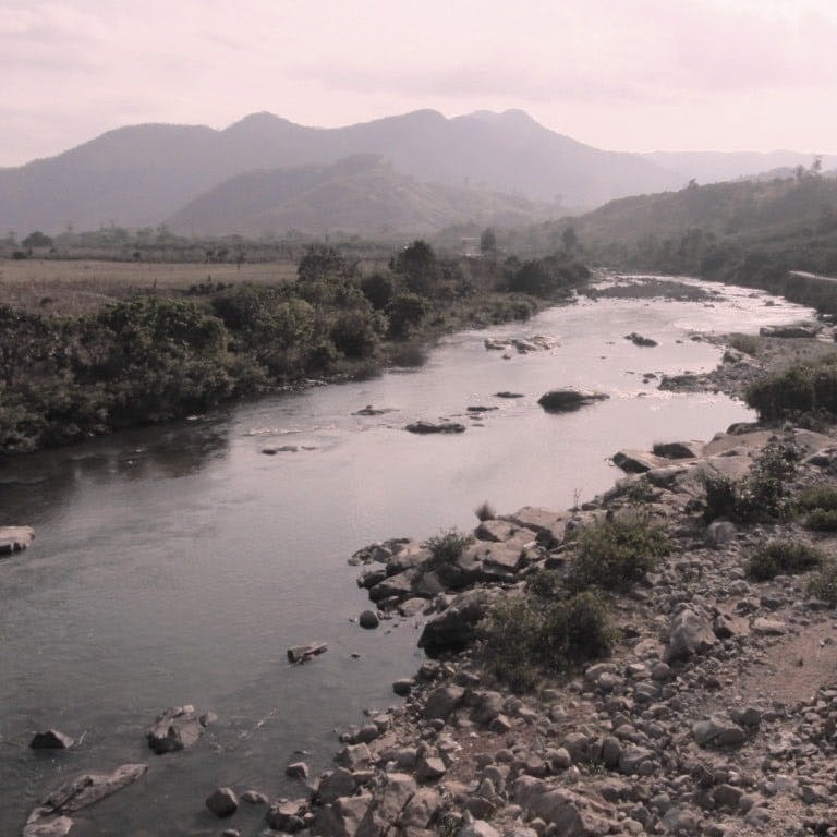
Descending from Dalat on Highway 27, a spectacular view opens up from the Ngoan Muc Pass. This is the Cai River Valley, a seam of glistening water meandering through one of the driest, most arid, and least populated landscapes in all Vietnam. A new road now follows the course of this important, shimmering waterway: all the way from its source, in the mountains above Cam Ranh, to its mouth, in the city of Phan Rang. Way off the beaten path, this is a superb little road trip, offering sumptuous scenery, freshwater bathing, and interaction with local minority groups. The River Road can easily be combined with other excellent routes in the area, namely the Ninh Thuan Loop.

The Cai River Valley: a new road follows the river from source to mouth making an excellent road trip
[Back Top]
MOTORBIKE GUIDE:
ROAD TRIP DETAILS:
- Total Distance: 140km (one way)
- Route: following the course of the Cai River [MAP]
- Road Conditions: good, paved single-lane & two-lane roads, occasional rough patches
- Scenery: rivers, mountains, forest, jungle, minority villages
ABOUT THIS ROUTE:
The Cai River bubbles to life somewhere in the hills west of Cam Ranh, before straddling the border of Khanh Hoa and Ninh Thuan provinces, and flowing into the East Sea at Phan Rang. Provincial Route 656 echoes the arcing course of the Cai River for much of its 135km length until Tan Son, from where Highway 27 follows the waterway to its mouth. I’ve written this guide starting in Phan Rang and ending in Cam Ranh: from the mouth to the source of the River Cai. However, you can, of course, ride it in either direction. It’s possible to comfortably complete the River Road in a day, but I prefer two. The best time of year is the dry season, from December to March, but weather conditions are generally good year-round. As well as outlining the route, I’ve included details of places to stay and eat along the way. The River Road can be extended into a beautiful loop from either Nha Trang or Dalat by combining it with the Nui Chua Coast Road or the Burnt Road.


The Cai River flows through lush forests and arid plains on its 135km course to Phan Rang
River Road: following the Cai River from mouth to source
[Back Top]
RIVER ROAD: THE CAI VALLEY
In Phan Rang, I prefer to stay on Ninh Chu Beach rather than in the town itself. The cheaper rooms at Bau Truc Resort are good value and right on the beach. Or, if you’re on a budget, rent a tent and camp by the ocean at the Ninh Chu Bay Beach Club, where the switched-on owners are doing a good job of creating some (much-deserved) buzz about Ninh Chu Beach and the area in general.
Leaving the crescent bay of Ninh Chu in the early morning sunshine, head south on the oceanfront road. When Yen Ninh Street veers left, continue straight ahead, towards the brand new An Dong Bridge, which spans the width of the Cai River mouth just before it empties into the East Sea. This marks the end of the river’s journey, the course of which you will be tracing – for the next 140km – back to its source in the lush forests and grape-blue mountains of the lower Annamite Range. Make a mental note of the colour and viscosity of the water here, because in a few hours’ time, further upstream, the Cai has a very different character.

The new An Dong Bridge crosses the Cai River at its mouth near Phan Rang
Keeping the Cai River on your left, wind along the wide, dry and dusty streets of Phan Rang, due west towards its twin city of Thap Cham. As the name suggests, this area was once a major centre of the ancient Hindu Kingdom of Champa. Although the Cham empire has long since vanished, its descendants still form a significant number of the population in this region, particularly in the remote rural areas, through which the Cai River flows. For a reminder of the glory days of Champa, turn right (due north) on Bac Ai Street and pay a visit to the impressive 13th century ruins of Po Klong Temple.

Ruins from the ancient Hindu kingdom of Champa (these are the Po Shanu Towers near Mui Ne)
As you head northwest on Highway 27 the cramped, concrete sprawl of Thap Cham slowly gives way to pockets of rice cultivation, vineyards (this area is where most of the grapes used in ‘Dalat Wine’ are produced), and occasional glimpses of the River Cai. With its banks lined with leaning clumps of bamboo, and fishing nets cast into the grey water from small wooden canoes, the Cai begins to exude some of its charm. Just south of Tan Son, the river splinters into rock pools and rapids, and there’s a wide view over its tumbling course as the road crosses a bridge.


The broad swell of the River Cai near Highway 27, half an hour west of Phan Rang
Tan Son is a small town sporting an incongruously grand boulevard for its high-street. Stop here for some food and drink, and pick up some supplies for a picnic too, because this is the last settlement of any real size for at least a couple of hours. There’s a decent guesthouse here if the hour is late: Nhà Nghỉ Phú Quỳnh (068 3 628 628) – it’s on the main street towards the northern edge of town, opposite a gas station. (For more about nhà nghỉ guesthouses in Vietnam see this).
From Tan Son turn right onto Road 27B (signposted to Cam Ranh). This is the beginning of the Burnt Road, a route I’ve written about before, which passes through an arid yet captivating region that I like to think of as Vietnam’s desert. However, after just a kilometre on the Burnt Road, turn left (due northwest) onto Provincial Route 656: the turn is signposted to Phuoc Binh just before crossing a bridge over the River Cai. At the junction here, Nhà Nghỉ Huong Giang (0913 930 526) is a guesthouse within easy reach of the river. However, construction of new irrigation channels has, for the moment at least, ruined what was once a pretty little bathing spot.

Swimming spots abound on the Cai River: this one is near the intersection with the Burnt Road
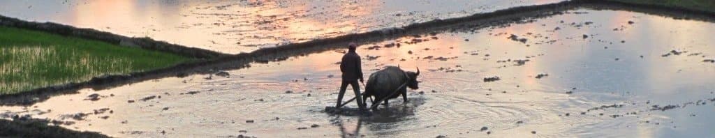
Provincial Route 656 starts in a flourish of green: acres of rice fields stretch to the water’s edge; the sea of green is ruffled by the wind and broken occasionally by mango, banana and cashew orchards, and lonely stands of spindly eucalyptus trees. Work animals lie lazily under trees, enjoying their mid-morning break, while conical-hatted women tend to the rice. The purple slopes of the Lang Bian Plateau rise to the north. The Cai Valley is wide here, much wider than the river itself, suggesting that what is today a pleasant vein of silvery water was once a wild, white torrent.

Water from the Cai River helps irrigate the surrounding farmland, which is lush and cultivated
The road winds deeper inland; the valley narrows, the slopes become steeper, and agriculture becomes less regular: farmland turns to forest. There are several hamlets spread around the area, connected to Route 656 by dusty roads. It’s worth exploring a couple of these as they usually end up on the riverbank, where perfect pebble beaches make it hard to resist a refreshing dip.
After passing a bridge on your right, the road veers sharply left. This marks the start of a brand new section of road that echoes the course of the older, dirt road, which you can still see running close to the riverbank. It can be a bit confusing at first, but as long as you’re heading north with the river to the east, you’re on the right track. The road is in excellent condition and, like so many new rural roads in Vietnam, there’s absolutely no traffic on it. In fact, there are more cattle than people in this empty, dry landscape. The light is clear and gold, and there’s a liberating sense of space.

Cows wander along the roadside with the Cai River flowing in the distance
When the new road meets the Cai River again, there’s a noticeable change in scenery. The valley is tighter, and the forests rising from the riverbank, which were previously crisp, dry and sun-drenched, are now lush, green and damp. The character of the river changes too: before it was a sliver strand flowing steadily and conspicuously through an arid, sandy savannah; now it’s a blue mountain stream sprinting off the highlands, skipping over rocks, and forging its path through dense jungle.

The Cai River Valley is lush and sparsely populated around Phuoc Binh Village – perfect for bathing
It’s not long before the new, two-lane road narrows into a single lane running very close to the river. There are several fantastic places to swim and camp along this section: look out for sandy river-beaches, and shady spots under cashew trees next to rock pools. But don’t make the mistake of thinking that you’re alone. Although the landscape may appear uninhabited, especially during the middle of the day, when the sun starts to sink local minority people – most of whom come from ethnic groups related to the ancient Cham – emerge from their bamboo homes, hidden in the forests, to fish, bathe, cook and play by the river.

Local children bathe, play and fish in the Cai River near Phuoc Binh Village
The River Road reaches its northern tip at the small but sprawling settlement of Phuoc Binh. A handful of local shops sell basic supplies here, such as water, candy, instant noodles and eggs (particularly useful if you’re camping), and bottles of gasoline. Local people (most of whom are from one of several ethnic groups descended from the Cham) are friendly and very surprised to see a người nước ngoại (a foreigner) riding through their hamlet. Many homes are still constructed in the traditional manner, using split bamboo.

Bamboo home in Phuoc Binh Village where many people belong to the Cham ethnic minority group
This is also the gateway to Phuoc Binh National Park. Rarely visited but rich in flora and fauna, the park headquarters are on the left as you pass through the village. Like many national parks in Vietnam, attempts at protecting the natural environment while also preserving the traditional culture of local ethnic groups often come into conflict. Slash and burn agriculture is being replaced by cash crops, but in reality both forms of farming badly scar the landscape and inevitably end up changing local culture forever. This is very apparent in Phuoc Binh, where much of the surrounding hillsides have been cleared for corn and cassava plantations, and concrete is replacing bamboo as the main building material.

Concrete homes are replacing bamboo ones in many minority hamlets along the Cai River
From Phuoc Binh the River Road curves east, following the course of the Cai up into the mountains, getting closer to its source. From here on, the landscape is far more populated than before, and the road surface deteriorates slightly. Farms, hamlets, villages, and towns line the route most of the way to To Hap, the largest settlement of them all. To Hap is a likable and seldom-visited town, surrounded by forests and rivers. A night here is a good off the beaten path experience. There’s accommodation at Nhà Trọ Song Nhi (83 Lac Long Quan Street: 0982 187 094): it’s not exactly luxurious but it’ll do for a night. There’s a gas station in town and several good street food stalls and cafes, most of which are in the streets on the north side of the high-street. Either side of To Hap there are lots of small roads leading north and south into the hills and forests which, if you have time, are good for exploring.

The River Road following the course of the Cai near To Hap Town
Riding out of To Hap, the Cai River looks cold and alpine as it flows through pine forests and corn fields: it’s a long way from its gaping mouth in Phan Rang, where it appeared hot, muddy, polluted and thick. Sadly, this is as far as Provincial Route 656 follows the River Cai: a few kilometres out of To Hap, the river veers south, climbing to its source in the hills, while the road heads east towards Cam Ranh. However, if you really want to get closer to its source, you can turn right (due south) and take Provincial Route 654 to Ba Cum Nam village.
A cold and winding pass crawls up and out of To Hap. At the top there are marvellous views due east all the way to the coast at Cam Ranh Bay. From here, the road drops sharply down the mountainside in a series of severe switchbacks. The landscape is quiet and still. An eerie silence settles over the forests, but soon the sounds of coastal Vietnam – traffic, industry, and development – take over as the outskirts of Cam Ranh Town come into view. It’s a dramatic change and one that you experience again and again each time you ride from the mountains to the coast anywhere in Vietnam.

Farming techniques haven’t changed much in hundreds of years along the Cai River Valley
Cam Ranh is not a particularly nice place, but there are guesthouses and food aplenty (a decent option is Hoang Nhat Hotel at 2128 Hung Vuong Street: 058 3855 696). It’s a logical place to spend a night before continuing your road trip, of which there are several options: head back to Phan Rang on the superb Nui Chua Coast Road or inland on the Burnt Road, or simply continue north on the scenic airport road to Nha Trang.
[Back Top]
RELATED POSTS:


[Back Top]
There’s a couple updates about Ninh Chu. Bau Truc Resort was bought and is now TTC Resort Ninh Thuan. Ninh Chu Bay Beach Club was bought, closed, and being developed.
Hi Mark,
Good to hear from you and thanks for the updates.
I haven’t had time to do a full rewrite of my guides in the Phan Rang and Ninh Thuan region recently, so I appreciate your comments.
Best,
Tom
This post is incredible, and the writer is a wordsmith that really evokes the spirit of travel to wild places. I will be doing this ride for sure now that I read this.
I’m hoping to find some more information about Phuoc Binh National Park. I’d really like to hike up to one of the peaks, but information thus far has been elusive. Did you stop at the park office? Do they have any trail maps and such?
Anyways, thanks for writing this article.
Hi Bruce,
I’ve been into the National Park HQ but there wasn’t much information available. I’m sure they will start to print maps with some trails on, but I haven’t seen any yet. It’s worth checking out though.
It’s a beautiful area and very few travellers pass through here yet.
Tom
Fantastic drive, just did it yesterday. Defintely needs a sleep at nha nghi Phu Quinh in order to have all the time required to enjoy part 2. Its perhaps my greatest ride in VN yet. Thanks for the very helpful advice!!!
Hi Nicolas,
That’s great. I’m glad you enjoyed it.
Tom