
First published February 2017 | Words and photos by Vietnam Coracle | 94 comments
This post was last updated 8 years ago. Please check the comments section for possible updates, or read more on my Updates & Accuracy page.
INTRODUCTION | GUIDE | MAP | RELATED POSTS
There are many ways to ride from Saigon to Dalat; from Vietnam’s biggest city to its most popular mountain retreat. Direct but busy routes along highways, scenic but indirect routes on quiet coastal and mountain roads, meandering back-road routes through farmland, and remote but challenging dirt road routes through jungle: the list is long and the combinations are endless. Which to choose depends on your time-scale, the purpose of your trip, and your level of motorbiking experience. Personally, I loath taking the main highways (QL1A and QL20). But, if you want to reach Dalat quickly, without taking the horrible highways, there are several great alternative routes. Using a combination of brand new (but empty) roads and old (but paved) back-roads, these routes offer relatively direct, traffic-free, and scenic ways to ride from Saigon to Dalat.

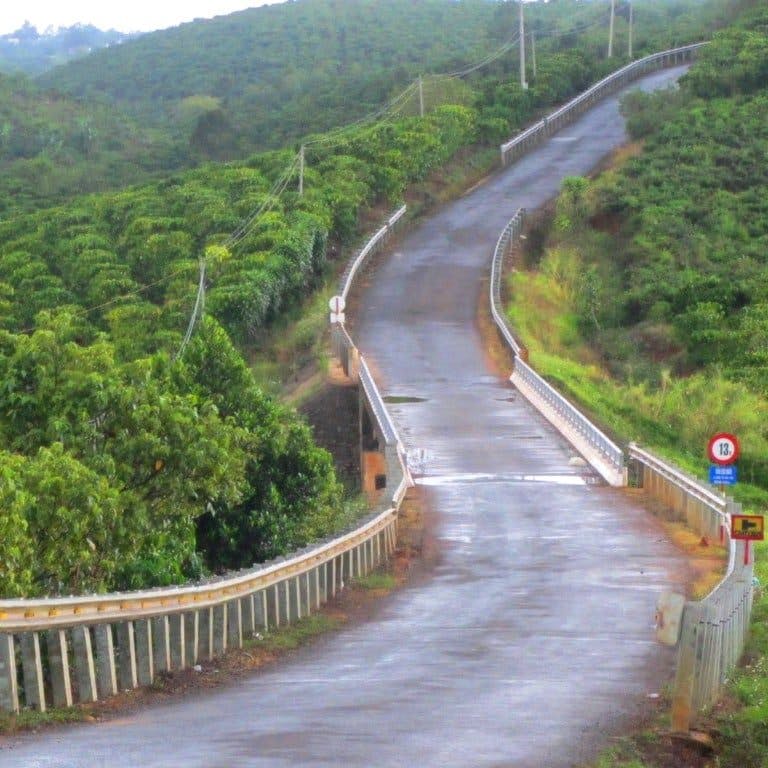
Excellent new roads & quiet back-roads make the ride from Saigon to Dalat enjoyable, scenic & safe
[Back Top]
SAIGON TO DALAT: THE BACK WAYS
ROAD TRIP DETAILS:
- Total Distance: 380km/360km/310km
- Duration: 1-2 days
- Route: three alternative, more scenic, routes from Saigon to Dalat [MAP]
- Road Conditions: excellent new roads, older paved back-roads, rough patches
- Scenery: farmland, mountains, rivers, forest, highland towns & minority villages
Selected Resources What’s this?
ABOUT THIS ROUTE:
In this guide I’ve outlined three ‘back ways’ from Saigon to Dalat. The main focus is to stay off busy roads and main highways as much as possible, while also being relatively direct and scenic ways to reach Dalat. In particular, I’ve concentrated on a 380km route (see the blue line on my map), but I’ve also included two variations of this route which are shorter: 360km (green line) and 310km (red line). These are all slightly longer than taking the main highway from Saigon to Dalat (300km), but the roads are in great condition (except for a couple of rough patches), the scenery is good, the traffic is light; it’s safer, easier, more rewarding, cleaner, healthier, and a lot more fun, than taking the highways. All the routes are rideable in a day if you start early, or just break the journey along the way with a night in either Cat Tien, Bao Loc, or Di Linh (at Juliet’s Villa). I’ve included recommendations of places to stay along the way in my description of the route below.

The ‘back ways’ from Saigon to Dalat are quieter, safer & a lot more fun than taking the highways
[Back Top]
ROUTE MAP:
Saigon to Dalat: the ‘Back Ways’
Blue line: 38okm | Green line: 360km | Red line: 310km
View in a LARGER MAP
[Back Top]
THE BACK WAYS TO DALAT:
Head southeast out of Saigon towards the Cat Lai ferry. The short river crossing over muddy, wide waters, takes you to Dong Nai Province: you’re already out of Saigon. Off the ferry, follow Road DT769 all the way along its meandering course, through industrial suburbs, to Long Thanh. It’s not a pretty route, but the road is wide, the surface is new, and the riding is easy. Wind through the urban sprawl of Long Thanh on Le Duan and Ha Ba Trung streets, until you rejoin DT769 heading east. This is another freshly laid section of smooth road curving through industrial zones and vast rubber tree plantations. Bear left onto DT25, which wiggles all the way to Dau Giay, a notoriously busy intersection of Highway QL1A (Vietnam’s main artery) and Highway QL20 (the main road to Dalat). Turn right (due east) onto Highway QL1A for a mercifully short and easy stretch to Long Khanh. Route Update: DT25 can be busy with heavy goods vehicles: an alternative and quieter route goes via DT770 and QL56 to Long Khanh (see the red line on my map). This route has recently been repaved and is now my preferred way to go.

The Cat Lai ferry takes you out of Saigon & into the industrial suburbs on good, new roads
Long Khanh is not a bad place to stop for a bite to eat and a coffee, before continuing east on the Xuan Loc-Long Khanh back-road. In excellent condition, this road follows the train line through lush farmland until it meets Road DT766. Turn left (due north) and follow this route (which turns into Road DT713) for 40km to just beyond Vo Xu. As you head further north on this road, the scenery gets greener, lusher, and brighter. Rice paddies glow in the sunshine, lotus lakes shimmer in the heat, eucalyptus trees line earthen dykes that divide the fields, and forested hills begin to appear on the horizon: the highlands are getting closer.

Things get greener as you approach the foothills of the Central Highlands on Road DT713
After Vo Xu, it’s decision time: For the shortest route to Dalat, continue straight ahead on DT713 (see the red line); for the middle distance route to Dalat, bear right onto DT717 (see the green line); or for longest but most scenic and rewarding route to Dalat – and the one that this guide continues to follow – turn left (due west) onto a small road, sometimes marked ‘Đường Đa Kai’ (see the blue line). There are a few potholes but, with the hills to the north and wide-open spaces to the south, it’s a pleasant ride across to meet Highway QL20, at Phu Lam. Turn Right onto the highway for a brief stint up to Ma Da Gui. A nice place to stop for a drink and a snack, Ma Da Gui signals your arrival in the Central Highlands. If the daylight is fading, or you’ve had enough of riding for one day, take Road 600A (just south of Ma Da Gui) to the village of Nam Cat Tien for a night in one of the good accommodation options at Cat Tien National Park. Otherwise, bear left (due northwest) at Ma Da Gui onto a new and, as yet, unnamed road towards Da Teh (also signposted to Cat Tien).


By the time you reach Ma Da Gui you’re in the highlands: the air is fresher & the scenery is pretty
After passing through Da Teh, the road turns northwards and is marked DT725. The first half is a wonderfully smooth and curling section of brand new mountain road, winding up the hillsides, looking down over rivers, reservoirs, forests and farmland. Eventually, the road surface deteriorates and turns into a ‘normal’ road, but it’s still an easy ride: up several remote and twisting mountain passes, through bleak-looking minority villages, dusty coffee plantations, pine forests and deep, dark, dense jungle. There are a couple of local guest houses (nhà nghỉ) in Loc Bac if you need them. The road turns southeastwards and, after a while, passes by the politically and environmentally contentious bauxite (aluminium ore) mines near Bao Lam. The latter is a sizable town just north of Bao Loc. If you want to break the journey, head down to Bao Loc for a night at one of its comfortable and affordable hotels or guest houses, such as Ngoi Sao Lien Do Hotel, among others. Don’t miss the great coffee and mountain views at Photo & Bike Cafe, and a breakfast bowl of noodles at Phở Kết (376 Tran Phu Street). (Note: Bao Loc is also where the other two alternative routes meet – see the red and green lines on my map.) If you don’t need a break, continue east through Bao Lam on Le Duan Street and out the other side.

An excellent but empty new road winds up the mountains behind Cat Tien and Ma Da Gui
The road, unnamed once again, bears northwest from Bao Lam and gets narrower, passing through an area of intense coffee farming. Because the forests have been cleared to make way for all the coffee bushes, there are no large trees – it’s a bald landscape – which means that the views are vast but fairly featureless. The air gets cooler as the road climbs higher onto the Di Linh Plateau. Depending on the season, this region is thick with either the nutty, earthy smell of drying coffee beans, or the sweet, jasmine-like aroma of coffee blossoms. It’s an empty, windy, invigorating ride all the way to the crossroads with QL28. If you’re running out of daylight hours, turn right (due south) on QL28 to Di Linh and find a guest house for the night on the main street, (or venture a little further from town for the excellent Juliet’s Villa Resort). If time is not an issue, continue straight over the crossroads, heading east.
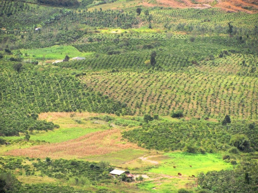
Coffee plantations dominate the landscape in this part of the Central Highlands
The first section of this road (unnamed, once again) is superb. There are several reasons for this, but first among them is the sheer riding pleasure. The asphalt is newly laid; treacle black and perfectly smooth. It’s essentially a motorcycle course in the mountains: a blend of long straights, hairpin bends, and meandering chicanes. The scenery is big: impressive for its scale and scope, if not for its natural beauty. Coffee bushes dominate the scene: it’s easy to see how Vietnam has become, in just over a generation, the second largest producer and exporter of coffee in the world. The road snakes off into the distance, up and down mountains, through valleys, bisecting the endless coffee plantations that appear to stretch westwards all the way to the Cambodian border. The tarmac bends and curls, and climbs and descends over the big, barren landscape, like a gigantic, black serpent, wriggling across the Central Highlands. After a while, the new road ends and the condition of the second half of the route, up to the junction with QL27 at Lam Ha, is only OK, so watch out for some potholes.
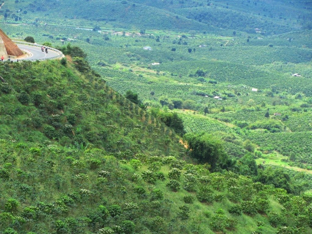
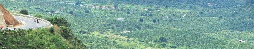
A new road winds through the mountains north of Di Linh: it’s fabulous riding & scenery
At Lam Ha, turn right (due east) onto Road QL27 and follow it for a few minutes before turning left (due north) onto an unmarked road towards Ta Nung Village. The Central Highlands is famous for its agricultural produce, so it’s no surprise that the landscape here is heavily farmed. It’s fun to try to identify as many crops as you can as you ride through this region: fruits, vegetables, and flowers of all varieties – some familiar, some strange and exotic – grow in abundance. Don’t forget to stop for a quick look at Elephant Waterfall, on your left, before reaching Ta Nung Village.
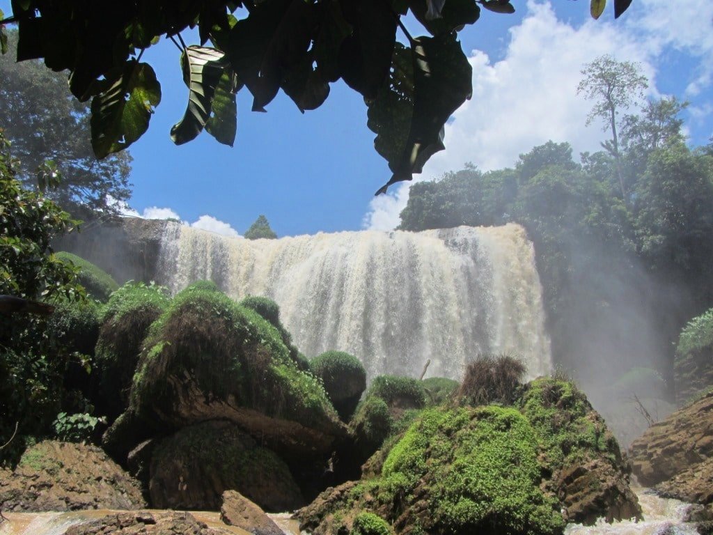
Elephant Waterfall is an impressive sight: don’t forget to stop by on the way up to Dalat
After Ta Nung, the road (newly resurfaced, once again) corkscrews up a cold but beautiful pass, ending in the pine trees and flower gardens of suburban Dalat. Bear right (due east) at the top onto Cam Ly Street, which then turns into Hoang Van Thu Street, taking you into Dalat city centre. My picks for places to stay in Dalat are: Budget: La Nha Homestay (a great new budget option in a refurbished French villa); Mid-range: the Du Parc Hotel (excellent mid-range value in an impressive French colonial building); High-end: Ana Mandara Villas (beautifully restored French villas on a hillside – by far the most atmospheric high-end lodgings in the Central Highlands). For many more budget options in Dalat click here; for more mid-range options click here; and for more high-end choices click here. (Please note: you can support my website by booking your hotels through the previous links: see below for details.)
*Please support Vietnam Coracle: I never write a post for money: all my content is free and all my guides are independent. You can support the work I do by booking your hotels via the Agoda links on my site, like the ones on this page. If you make a booking, I receive a small commission (at no extra cost to you). Any money I make goes straight back into this site. Thank you.

Dusk, Xuan Huong Lake: Dalat is Vietnam’s premier mountain resort town; a favourite for honeymooners
RELATED POSTS:
[Back Top]
Thanks for the nice route~
I am cyclist, I followed your route (blue line) from Saigon to Dalat during May holidays.
I made it in 4 days, with stops in Vo Xu (km 140), Nam Cat Tian (km 200) and ốc Thằng (km 300).
Hi Matthieu,
Thanks, I’m happy to hear you enjoyed the route and have the energy to do it on a bicycle too!
Best,
Tom
Hi Tom,
Nice works thanks a lot. How can I import your itinerary in my phone ? Cause I don’t have PC and I can’t do it easily !
Thanks a lot
Hi Greg,
You can just open my route map in the Google Maps app on your phone. If you don’t know how to do, you can just google it.
Best,
Tom
Hi Tom, I’m a Viet kieu returning to the motherland to visit this week! Will be embarking on this journey tomorrow with my husband. Thanks for an informative post we look forward to the journey. We will be staying in cat tien as a stop over on the way there and back.
Thanks again!
Hi Monica,
I’m glad to hear you’ll be riding this route. Please note that you can’t take the red route between Long Thanh and Long Khanh at the moment because they are constructing the new airport, so take the blue route instead.
Best,
Tom
Hi Tom, great advice and map. I’ve read through the post and comments, do you have any more recent updates to these routes? I’ll be riding with my girlfriend and neither of us have experienced the busy roads on a bike yet. Thanks!
Hi Andy,
These are still good. However, between Long Thanh and Long Khanh you can’t follow the red route anymore because that is the construction area for the new airport: instead, you can just follow the blue route. After Long Khanh, all the routes are fine.
If you want to avoid busy roads, stick to the blue route all the way, and don’t leave/return to Saigon during the rush hour periods.
Best,
Tom
Tom thank you so much for this route. I made it to Dalat today and it has been amazing the entire way, especially the road between Cat Tien and Dalat. I did it over 3 days, stopping in Cat Tien and Bao lat.
I’m due to head to Phan rang next, any advice on the best way to go? Conscious that it’s a lot of downhill and want to be as careful as possible.
Thanks again!!!
Hi Dave,
I’m glad you enjoyed the ride.
From Dalat down to Pham Rang, the direct route on road QL20 & QL27 is excellent.
Have fun,
Tom
Thanks Tom, this is really helpful. I will start my tour in Ho Chi Minh in september.
I have made the route myself in Google Maps with the help of your map. Just needed to add some extra stops and swipe the line through. I am all set for the first part!
grtz Michael
Thanks, Michael.
It’s worth bearing in mind that there’s now a lot of construction work around Long Thanh because of the massive new airport that’s being built – there may be trucks and dust and perhaps some road closures around there.
Best,
Tom
Anyone could advise how long the trip from HCMC out to Bao Loc would take on the exact same route? I might only be able to start the trip at 11am in the morning and was worried if there will be enough sunlight to get to Bao Loc
Hi Paula,
It takes between 4-6 hours to ride from HCMC to Bao Loc on the most direct of the three routes outlined on this page above. So if you left at around 11am you could expect to arrive in Bao Loc by around 4-6pm.
Best,
Tom
We decided to stop in Bao Loc. It turned out to be quite the enjoyable town and I’d recommend anyone else who need a stop around that area to consider it. There are lots of interesting shops, a good assortment of food options and decent cafes.
FYI, Google is saying that Elephant Falls is currently closed. The reviews say there is a new owner and they are doing renovations. Seems it’s been closed since Nov 22 (and its Jan 23 right now).
Hi Tom,
Thank you so much for putting these excellent guides together. I’m planning on riding from Ho Chi Minh to Bao Loc and back to Ho Chi Minh (using your guide) in a couple of weeks and have a couple questions:
1. Would you say that the route is safe for a first time scooter rider?
2. Is there a particular route that would be the safest (quality of roads/traffic)?
3. Is there an option to ride to Bao Loc and then take a train back to HCM with the rental bike?
Thanks,
Chris
Hi Chris,
If you are riding for the first time, it’s important to stay off highway QL20 if possible, because it can be busy with trucks and traffic, especially the Bao Loc Pass, which is about 10-20km south of Bao Loc; so try to stick to the green or blue routes, which are all paved and in decent condition with light traffic for most of the way.
However, the first hour or so riding out of Saigon can be busy and a bit overwhelming no matter which route you take. See this article.
Give yourself plenty of time: Saigon to Bao Loc on these routes take a minimum of 4 hours, but you should expect more like 6-7 hours if this is your fist road trip.
Coming back, it is possible to ride from Bao Loc to Phan Thiet on this route, then put your bike on the train from Phan Thiet to Saigon. However, the train is currently only running from Friday-Sunday.
Which ever route you decide to take, you of course need to be very careful on the roads.
I hope this helps,
Tom
This is very good advice. My wife is a new rider and we have just finished our 1st week of riding. Our rental company QL20 out of Saigon and it was very tough for her. She made it but was very nervous and didn’t enjoy it. We’ve used Tom’s routes for the rest of the way to Dalat and they have been a pleasure. We especially like Bao Loc to Dalat on the 725.
Hi Athir,
Thanks for your trip report. I’m glad you enjoyed your ride up to Dalat.
Yes, QL20 is quite busy and horrible these days – it’s much better to take 725 instead – better scenery too.
That’s interesting about Elephant Falls. I’m sure they will open again soon – maybe for the upcoming Tet holidays.
If possible, try to ride the Pine Tree Road while you’re up in Dalat, or take a look at these Dalat Routes.
Best,
Tom
Hi Tom,
Thanks for all the amazing work you’ve done, it is truly appreciated. I was planning on taking the back roads from Saigon to Dalat and then heading to Cam Lap. Do you have any suggestions on roads between Dalat and Cam Lat?
Thanks!
Hi Kevin,
Thanks for your kind words.
From Dalat to Cam Lap I would take QL20 and QL27 east from Dalat down to the crossroads at Tân Sơn, then bear left onto QL27B which takes you all the way the coast very near Cam Lap. Alternatively, you could continue from Tân Sơn straight on QL27 to Phan Rang and then take the Nui Chua Coast Road to Cam Lap. They are both good rides on good roads.
Please bear in mind that my Cam Lap guide and this Dalat Back Ways guide haven’t been fully updated for a while. So check the comments for any reader updates. However, I’ve been on all these roads recently and they are mostly still good.
Best,
Tom
Hi Tom!!! Great guides, we followed the extreme Ha Giang loop map two weeks ago, and it was a perfect ride.
Now we are planning to grab a motorbike in Dalat to go to ho chi minh, following this route:
1. Dalat – Nha Trang
2. Nha trang – Phan rang
3. Phan rang – Mui ne
4. Mui ne – Bao loc- Cat tien
5. Cat tien – Ho chi minh
Do you think that this is a good idea? 4-5 days…
If you have any suggestions, that would be great for us
Thank you very much!
Hi Alejandra,
Yes, that route is good. It’s a lot of riding, but the roads are good and so is the scenery.
From Dalat to Nha Trang take road QL27C.
From Nha Trang, take the coast road to the airport then join up with the Nui Chua Coast Road to Phan Rang.
From Phan Rang, take the Dragons’ Graveyard road and link it with the Sand Dune Highway to Mui Ne.
From Mui Ne/Phan Thiet, take QL28 to Ma Lâm then turn off due west on DT22 which links up with QL55 from where you can work your way up to Bao Loc or down and across west to Cat Tien.
I hope this helps,
Tom
Hi Tom, just planning out a bicycle ride from HCM to Dalat. Probably over three to four days. Which of your routes would be best? Planning the ride for september or october 2023. Will be continueing to Cam Ranh from dalat after a few days of exploring in Dalat. Any advice on that part of the route?
Hi Richard,
Well, assuming your priorities are nice roads and good scenery (and that you don’t mind some major climbs on the bicycle), the blue route on my map is the best option.
From Dalat to Cam Ranh take road QL20 and QL27 due east until the intersection at Tân Sơn (also called Ninh Sơn). From here either take QL27B or DT656 to Cam Ranh – both are good roads and scenery.
Best,
Tom
Hey Tom.
Truly excellent website. Thank you so much for all your time, effort and wonderful experiences.
I’m coming over to HCM with my daughter in September. Gonna make a motorbike tour HCM to Dalat:
Which would way would you recommend (personal fav)? This route you’ve mentioned here (the backways to Dalat)? We’ve got any where from 3 – 5 days.
Cheers
Jay
Hi Jay,
Thanks for your kind words.
Yes, the blue route on this page is very pretty, especially the second half. A good way to experience this ride would be to start early from HCM and ride up to Cat Tien (roughly halfway) for the first night. The next day get another early start and ride all the way to Dalat – that should be an enjoyable two days on the road. (Just bear in mind that the first hour or so getting out of HCMC is always a bit grim – I’ve written about that on this page.)
Other than the routes on this page you might want to take a look at the Dak Nong Geopark Loop and an excellent day ride from Dalat is the Pine Tree Road. Also, of course, my 5 Dalat Routes & Loops.
I hope this helps,
Tom
Any recommendation route for saigon to Nam Cat Tien and back?
Hi Sam,
Sure, you can use the blue route in the map on this page to go one way, and then you could take the blue route in the map on this page to go a different way back (or just take the direct route on QL20 instead).
Best,
Tom
Hi Tom,
Thanks for all the amazing work you do. I am planning on taking the blue route to Dalat in a few weeks time – would you say that this is doable on an automatic bike (155 cc)? Thanks in advance for your response.
Best wishes,
Kevin
Thanks Kevin,
Yes, the blue route should be absolutely fine on a 155cc automatic bike.
Best,
Tom
Hi Tom,
Really appreciate the work you do.
We are looking at driving to Cat Tien from Saigon, following your route, and then staying a few days there. Is there a route that you would recommend for a 2 day drive back to Saigon?
Thank you again,
Danny
Hi Danny,
From Cat Tien back to Saigon you could follow the relevant parts of the route map in my Dak Nong Geopark Loop guide (but don’t take the ‘rough road’ around the northeast shore of Tri An Lake).
Alternatively, you could continue up to Bao Loc then take QL55 down to Lagi, along the coast road to Vung Tau and get the ferry to Can Gio, then back into Saigon.
I hope this helps,
Tom
Hi Tom,
We are just about to start the drive to Dalat following your blue route! Is there a way once in google maps to start the directions following your blue route!?
Thanks!
Hi Natalie,
You can try clicking the option ‘Download KML’ from the map and then open that file in your Google Maps app. But it works differently on different phones.
Also, on the blue route, you should now be able to take the red line between Long Thanh and Long Khanh (although it’s possible there may still be some construction on it).
I hope this helps,
Tom
Thank you for this amazing blog. I came to Vietnam a couple of months ago and this was my first trip ( 29th April )Followed the blue lane all through and it was probably amongst the top 5 rides I’ve ever did. 8 hrs of riding with 2 breaks and I was in Dalat. Rode on to Nha Trang the next day and back via CR to Cat Tien. Did some part of the return journey the red line but went back to awesome blue line , took me an additional hour but was totally worth it. Looking forward to the next ride
Few updates , the CatLai ferry currently only operates from 5 am only, the Elephant falls is currently shut down.
Thanks, Joseph.
Sounds like a lot of fun. I’m glad you enjoyed it.
Thank you for the updates. I wonder why Elephant Falls is closed – perhaps they’re doing renovations. I think with the Cat Lai ferry, it’s possible that it only stopped running through the night over that holiday weekend: usually, the ferries run every 30 minutes through the night.
I hope you enjoy many more rides in Vietnam.
Best,
Tom
Hey Tom,
I’ve just done a sizable part of the blue route, from Phuong Lam to Loc Bao. It was a really scenic and enjoyable ride, thanks a lot for the itinerary… and all your other routes I’ve tried in the past two years.
I’m just writing to add two updates. First, there’s a massive road construction after Da Teh for about 5km, followed by incredibly bad road for another 5km. I guess it’ll be finished by mid 2020.
Second, some may think of a detour from Loc Bao to the Dong Nai 4 reservoir, or on to the Ho Chi Minh road. The route includes a section with truly stunning views around the lake. The connecting road, QL28, is in generally good condition, with the exception of the part around the lake, which is full of potholes and unpaved patches.
Hi Ed,
Thanks for the update about the road conditions near Da Teh. That seems strange – it was in perfect condition not long ago, so I wonder why they’re doing works on it.
And, yes, I totally agree about the detour northwest on QL28 towards Ta Dung Lake – I’ve just written a guide to that route which will be published very soon here.
Thanks,
Tom
Tom,
How often do the Cat Lai ferries depart Saigon and do you know how early they begin? I’m doing this trip in Feb and want to get away nice and early in the morning. I can’t find a timetable anywhere online. Also, I plan to ride from DaLat to Phan Thiet and get the train back to the city. Will I have any issues getting an XR150 on the train?
Thanks mate.
Hi Shane,
The Cat Lai ferry runs 24 hours: every 5-10 minutes during the day; every 30 minutes during the nights.
You should be able to get your bike on the Phan Thiet train, but it will probably cost more money. I can’t guarantee they’ll accept XR150s, but I’m pretty sure it’ll be OK.
Tom
Hi Tom, update on the green marked road condition:
Coming from direction of Saigon:
First section till the split off for Phan Tiet is ok, 2-3 rough patches for about 20meters each,
there’s also a bit off traffic on this section,
after the split the road becomes good and about 20km later it becomes great (fresh-ish tarmac)
last 25km to Bao Lac it reverts to ok but no real rough patches.
Hope that’s useful to you/others.
Have a great day on the road all.
Hi Tijl,
Thanks for the updates, that’s very useful. And I’m glad you used the guide.
Tom
Hi Tom, great info again on this motorcycle riders mecca, (or is that mocca, for all the coffees to be had).
The run from Saigon to Vung Tau, while a little hectic is a good start.
From VT you can continue along the QL55 coast roads to La Gi and Phan Thiet before heading up the mountain roads of QL28 to Di Linh and Juliets, avoiding the main Hwys altogether. From there to Dalat on the QL20 or along the mountain roads of QL27 and QL27b to Cam Ranh Bay and Nha Trang……great roads and no police…yet
Just waiting to return for some of these wonderful trails/
.
Hi Rory,
Yes, thanks. I’ve written about those routes in the following guides: Ocean Road | Binh Thuan Back-Roads | Southeast Loop | Tet Classic | Burnt Road | River Road | Juliet’s Villa
Tom
Hey Tom,
Thank you so much for your beautifully written guides. After my upcoming trip I definitely plan to donate to help maintain the site and as a thanks for all of the incredible work you do.
This guide is great for me as I’m fairly worried about navigating the Saigon traffic and am hoping to make this journey as safe as I can. I was originally planning on leaving Saigon towards Dalat using this guide on Thursday, May 2. However, reading the comments in your HCM Road guide, I saw you had mentioned that “any time of day Sunday” would be a safe option to someone else who had been asking about safety. Just wondering if you still think Sunday might be the safest day of the week to start this journey and avoid as much heavy goods traffic as possible? Would it be a significant difference compared to leaving around 10am on Thursday?
Thanks again for your incredible guides and for your help!
Hi Justin,
Well, it’s difficult to say for sure. Yes, Sunday is usually a better option, but this Sunday is part of a big holiday weekend so you might find there’s a lot of holiday traffic leaving the city. Alternatively, if you leave on Thursday instead, try leaving Saigon either very early in the morning (4am) or late at night (after 8pm) or during the lunch hour (if you leave at 10.30-11am you might have a couple of hours of less busy roads to get out of the city).
Thanks for considering donating: if you do, please see my Support Page for details.
I hope this helps,
Tom