
Last updated June 2020 | Words and photos by Vietnam Coracle | 35 comments
This post was last updated 5 years ago. Please check the comments section for possible updates, or read more on my Updates & Accuracy page.
INTRODUCTION | GUIDE | MAP | RELATED POSTS
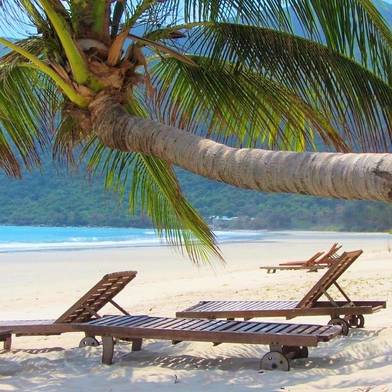
Vietnam’s coastline stretches over 3,200km from the Gulf of Thailand in the south to the Gulf of Tonkin in the north, and offshore there are thousands of isolated islands and archipelagos. In general, the best beaches in Vietnam are found in the southern and central regions of the country: blue bays, hidden coves, white sands, swaying palms, dramatic cliffs: Vietnam has it all. On this page, I’ve compiled a list of 23 of the best beaches in southern and central Vietnam. I’ve chosen these beaches on a number of criteria: beauty, cleanliness and tranquility are obviously important, but so too are other factors, such as convenience, potential, atmosphere, and being off the beaten track. This is a personal list: of course I haven’t visited every beach in Vietnam and of course this list is entirely subjective. Nonetheless, the beaches on this page are based on my experience of over a decade travelling Vietnam’s coastline and islands.

[Back Top]
23 BEST BEACHES IN SOUTHERN & CENTRAL VIETNAM
Each of the 23 beaches in this list features a written description and bullet-points of information, such as location, when to go, nearest transportation hubs, accommodation, links to relevant Vietnam Coracle guides, and lots of photographs. In addition, every beach is plotted on my map. Some of the beaches in this list are already well-known, but others are rarely visited. Many of the 23 beaches on this page are best visited with your own wheels, but some are easily accessible from major towns, while others can be reached via public transportation connections, taxis, ride-hailing services, boats, or transfers arranged by your accommodation. I have chosen to focus only on the beaches of southern and central Vietnam because I know these coastlines far better than I do the northern coast, although I’m sure there are many great beaches there too. You’re welcome to suggest other beaches in the comments section at the bottom of this post (but please no advertising within comments, otherwise they will not be published). Take note of these Vietnamese words: bãi = beach, vịnh = bay, mũi = cape, hòn = islet. The following beaches are not in hierarchical order: I like each one just as much as the others.
LITTER & ENVIRONMENT: Vietnam is currently facing a massive trash problem, particularly in its oceans & on its beaches. No beach has escaped. Sadly, most of the visible trash that blights Vietnam’s beaches is personal or household litter or fishing-related debris. As depressing as this is, when you visit these beaches try to be patient & understanding, and set an example by disposing of your own litter responsibly & trying to limit your consumption of single-use items.

- 8: Bai Om Beach
- 13: Rach Tram Beach
- 14: Ky Co Beach
- 15: Hon Gom Sandbar
- 16: Tam Thanh Beach
- 17: Bai Rang Beach
- 18: Ong Lang Beach
- 20: Lien Huong Beach
- 22: Bai Nho Beach
MAP:
23 of the Best Beaches in Southern & Central Vietnam
SEARCH & BOOK TICKETS:
*Please support Vietnam Coracle: you can search & book ferries, flights, trains & buses to most of the beaches in this guide by using the Baolau.com search box below or by following the links in this guide. If you make a booking, I receive a small commission. All my earnings go straight back into this website. Thank you.
1. VỊNH HÒA & TỪ NHAM BEACH & BAY:
• Location: Phu Yen Province, south-central coast [MAP]
• When to go: March-September
• Getting there: nearest transport hubs for flights, trains & buses: Tuy Hoa & Quy Nhon
• Where to stay: Ocean Beach Hostel & Timothe Beach Bungalows
• Related guides: The Beaches of Phu Yen & Quy Nhon: A Guide
• Description: Xuan Thinh Peninsula juts out into the East Sea, about halfway between Tuy Hoa and Quy Nhon. Accessed via small paved lanes and dirt tracks, this finger of land hides some extraordinary beaches and coves, none of which are currently developed. Along the east coast of the peninsula, the road rises sharply through eucalyptus trees, over sand dunes, and down onto the casuarina tree-lined beach of Tu Nham. This gaping bay is enormous, and the empty sands stretch for kilometres, lapped by cool-blue seas. You’ll have to accept a general level of trash on the sand, but you’ll also have the entire beach to yourself. At the northern end of the bay is Vinh Hoa, where a small fishing community presides over a wonderful sweep of bright sandy beach, lined with palms and backed by wooded hills. What’s more, there are two good-value places to stay right on the beach: isolated, quiet, and off the beaten track, you could easily while away a day or a month here. (You can read more about Vinh Hoa & Tu Nham Bay in my Beaches of Phu Yen & Quy Nhon Guide.)

• Images of Vinh Hoa & Tu Nham Beach


2. CÂY MẾN BEACH:
• Location: Nam Du Island, Kien Giang Province, Gulf of Thailand, off the southwest coast [MAP]
• When to go: October-May
• Getting there: daily boats from Rach Gia & Phu Quoc; nearest transport hubs for flights & buses: Rach Gia & Phu Quoc
• Where to stay: many good, cheap guesthouses around the island
• Related guides: Nam Du Islands: Travel Guide
• Description: On the west coast of Hòn Lớn (the largest island in the Nam Du Archipelago), Cay Men is one of the most picturesque beaches in the country. This glorious white sand beach is fringed by leaning coconut palms, which appear to be kowtowing to the ludicrously turquoise waters. The surf is gentle, there’s a light sea breeze through the rustling palms, trash appears to be under control, and jungled hills rise steeply behind. The beach is easily accessed off the coast road via a paved lane. A couple of low-impact wood-and-thatch huts serve fresh, utterly delicious, local coconuts – ask for a trái dừa lửa, they’re the sweetest and tastiest I’ve every had – as well as some seafood, light snacks, soft drinks, and beer. But, best of all, you can camp here for virtually no money at all: surely, one of the best camping spots anywhere in Vietnam. As you might guess from the images below, swimming at Cay Men beach is wonderful. The water is clear and shallow, and there’s hardly any current. It gets busy on weekends, but during the week there’s likely to be no one here, especially in the middle of the day. However, change is surely on its way, and a new fast boat ferry connection to Phu Quoc Island is only the beginning. (You can read more about Cay Men Beach, including transportation information, in my Nam Du Islands Travel Guide.)
• Images of Bai Cay Men Beach


3. BÃI TRÀNG BEACH & MŨI DINH CAPE:
• Location: Ninh Thuan Province, south-central coast [MAP]
• When to go: December-August
• Getting there: nearest transport hubs for trains & buses: Phan Rang & Phan Thiet/Mui Ne
• Where to stay: guest houses & hotels in Phan Rang
• Related guides: Dragons’ Graveyard Coast Road: Phan Rang to Ca Na
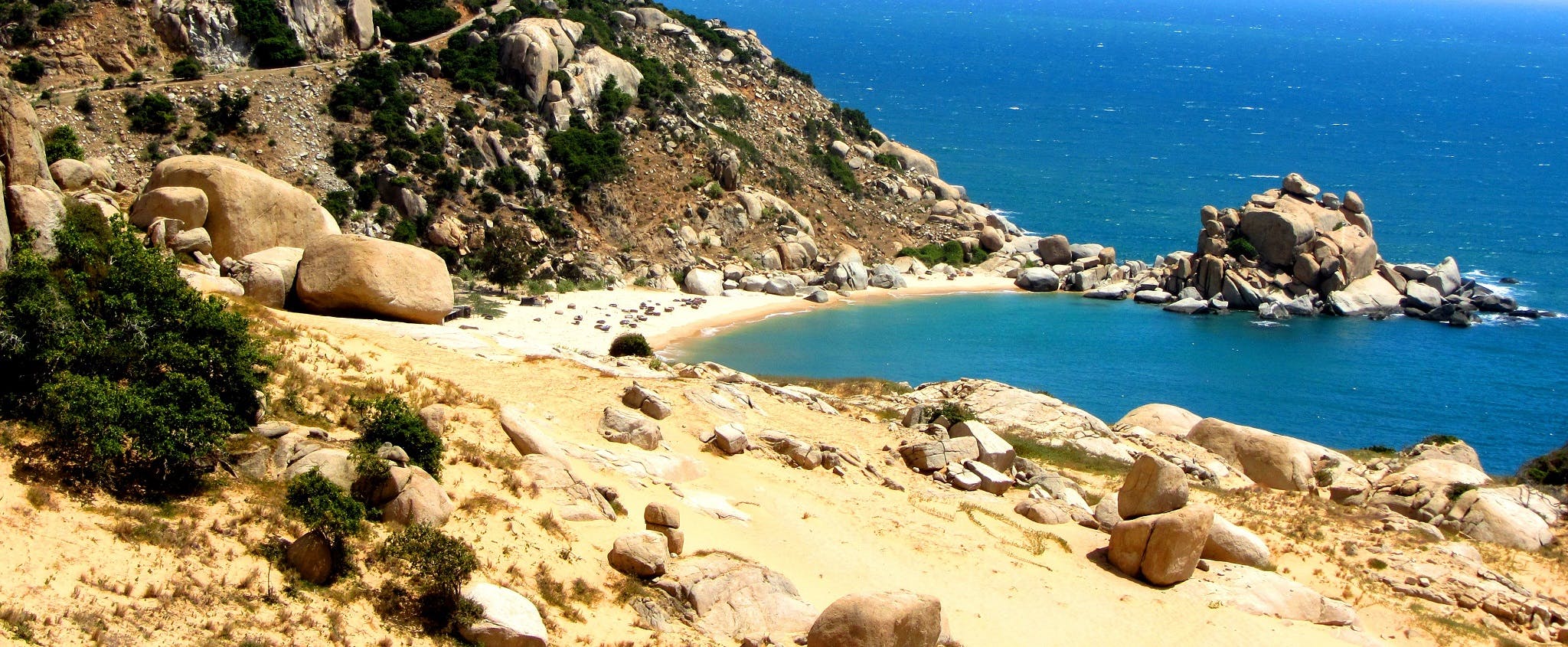
• Description: A sandy, boulder-strewn bluff on the south-central coast, Mui Dinh Cape is as close as Vietnam gets to a desert. Hiding wild, windy and isolated beaches, the landscape here is striking, arid and empty. Huge boulders dot the coastline, planted in large drifts of smooth sand; cacti grow on the rugged hillsides where goats gnaw at whatever greenery they can find; and the ocean is a deep blue with white crests whipped up by the hot, sandy wind. A stunning new road soars across Mui Dinh Cape: one of the most spectacular coastal routes in Vietnam. At the eastern-most point of the cape, a French colonial-era lighthouse sits atop a huge rockpile, below which is a perfect crescent of white sand and calm, turquoise water. This is Bai Trang Beach, only accessible on foot (or off-road vehicle) through drifts of sand and over giant boulders. But it’s worth the trek to get here, because the beach is glorious, the swimming is excellent, and you can even camp here too. (You can read more about Trang Beach & Mui Dinh Cape in my Dragons’ Graveyard Coast Road Guide.)

• Images of Mui Dinh Cape & Bai Trang Beach


4. BÃI NHÁT BEACH:
• Location: Con Son Island, Ba Ria-Vung Tau Province, off the southeast coast [MAP]
• When to go: March-August
• Getting there: daily flights from Ho Chi Minh City & Can Tho; daily ferries from Vung Tau, Can Tho & Soc Trang
• Where to stay: lots of accommodation on Con Son Island
• Related guides: Con Dao Islands: A Guide
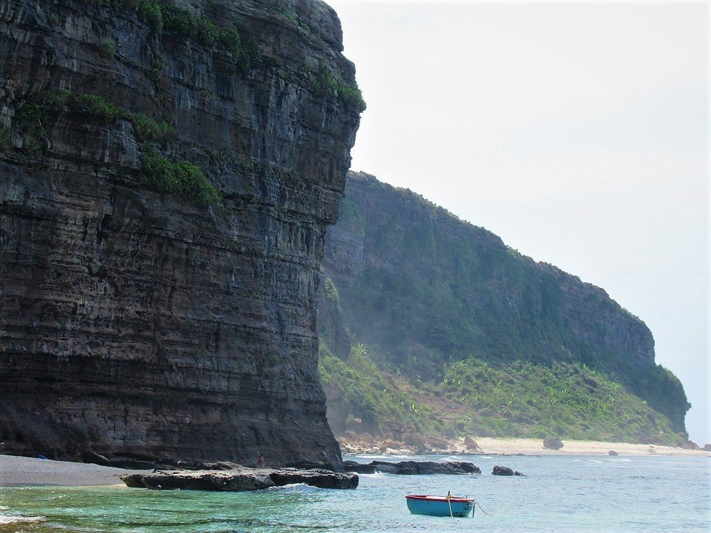
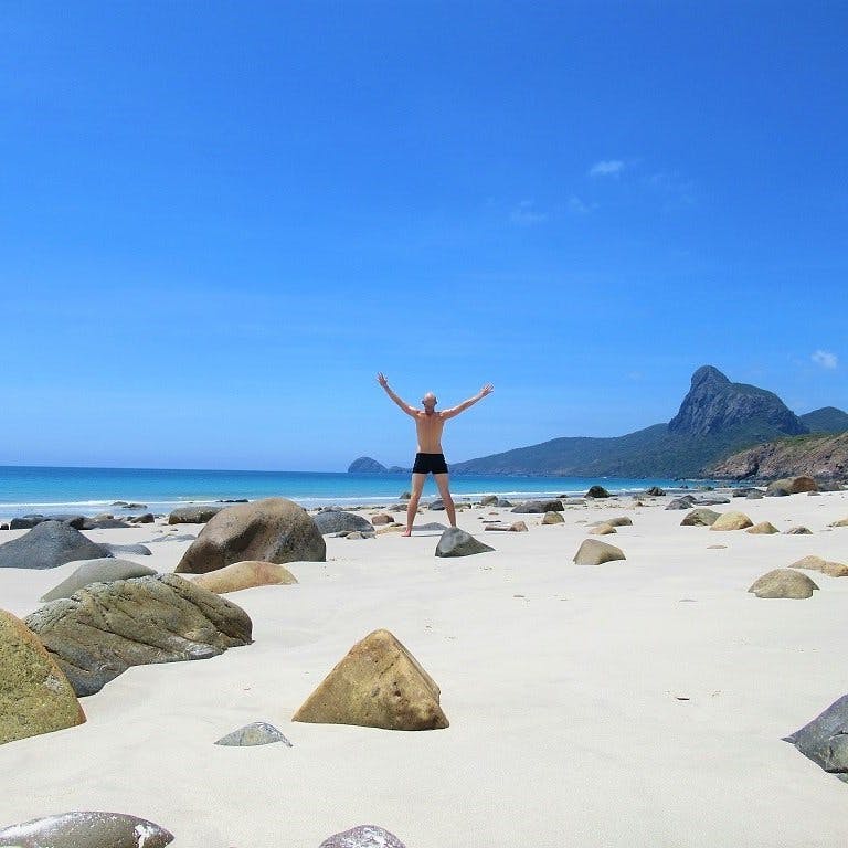
• Description: Near the southern tip of Côn Sơn (the largest island in the Con Dao Archipelago), Nhat Beach is a long seam of rice-white sand, lapped by gin-clear seas, behind which a Jurassic Park-like landscape forms one of the most striking coastal vistas in the country. Reached via a spectacular coast road winding around Mũi Cá Mập (Shark Cape), you can see the road cutting along the coastline below the windswept southern slopes of Núi Thánh Giá, the highest mountain on the island. Big boulders lie strewn on the sea side of the tarmac, decreasing in size as they roll down to meet the bright sand and blue water of Nhat Beach. The swimming is excellent, especially before noon, when the water is often calmest, and when the tide is usually out so that more beach is exposed. However, there is hardly any shade on Nhat Beach, and it is increasingly difficult to ignore the landfill on the opposite side of the road, a reminder of how fragile this island is. (You can read more about Nhat Beach in my Con Dao Islands Travel Guide.)
• Images of Bai Nhat Beach


5. HUE TO DONG HOI BEACHES:
• Location: Thua Thien Hue, Quang Tri & Quang Binh provinces, central coast [MAP]
• When to go: April-September
• Getting there: nearest transport hubs for flights, trains & buses: Hue, Dong Hoi, Dong Ha & Quang Tri
• Where to stay: a handful of guest houses near coast or stay in Hue or Dong Hoi
• Related guides: Tomb Rider: Hue to Dong Hoi on Coastal Back-Roads
• Description: The coastal region between Hue and Dong Hoi, in central Vietnam, is rarely explored by foreign visitors: most people, if they stop here at all, head inland to war-related sites around the former DMZ. This has left a barely believable stretch of unbroken beach almost entirely unvisited. Coastal back-roads, covering almost 200km of completely empty beach, lead from Hue to Dong Hoi. Characterized by calm blue sea and long arcs of bright sand where fishermen pull up their svelte-looking wood-and-weave fishing canoes, these roads take you along a glistening coastline strewn with royal-style tombs. At regular intervals, little concrete pathways lead off to the beach. Take any of these and you’ll emerge from the trees onto seemingly endless swathes of white sand and sparkling blue sea. You’ll need your own wheels, of course, and there’s a fair amount of fishing-related debris left on the sand: these are working beaches. Try to avoid October-March, as the sea can be rough and the weather grim during these months. (You can read more about the beaches from Hue to Dong Hoi is my Tomb Rider Coast Road Guide.)
• Images of the Beaches from Hue to Dong Hoi


6. BÃI NGANG BEACH:
• Location: Dao Be Island, Quang Ngai Province, off the central coast [MAP]
• When to go: March-September
• Getting there: daily boats to Sa Ky Port; nearest transport hubs for flights, trains & buses: Chu Lai, Quang Ngai, Tam Ky & Danang
• Where to stay: a couple of good, cheap homestays
• Related guides: Ly Son Island: Travel Guide
• Description: Ngang Beach is located on Dao Be, a tiny volcanic islet off the coast of central Vietnam. The islet is mostly flat (indeed, it’s not much more than an oversized reef), but at the northern tip several strands of black volcanic rock (presumably formed by lava when it reached the sea) coalesce to from a series of jagged cliffs and coves. One of these coves hides a powdery, flour-white, sandy beach dotted with colourful fishing coracles. The surf is perfect blue as it washes up on the white beach beneath the black cliffs, and the juxtaposition of colours is eye-popping. Swimming is good, and there are a few refreshment shacks nearby. Trash used to be a major problem here, but a couple of years ago a new and innovative recycling scheme was implemented, which has been hugely effective in cleaning up the environment on the islet. Ngang Beach is reached via fast boats to Dao Be, which shuttle passengers from the bigger island of Ly Son. There are also a few good homestays on Dao Be. (You can read much more about Ngang Beach and Dao Be Islet in my Ly Son Island Travel Guide).
• Images of Bai Ngang Beach


7. BÃI MÔN BEACH & VŨNG RÔ BAY:
• Location: Phu Yen Province, south-central coast [MAP]
• When to go: March-September
• Getting there: nearest transport hubs for flights, train & buses: Tuy Hoa, Dai Lanh
• Where to stay: camping on the beach or hotels in Tuy Hoa
• Related guides: Vung Ro Bay: Travel Guide
• Description: Formed by a tongue of rugged land that spreads southwest, sheltering the main shoreline from the winds and weather coming off the East Sea, Vung Ro is a large bay dotted with hundreds of floating homes, fish farms and wooden fishing boats. A dramatic backdrop is created by craggy, forested mountains that culminate in an 80-metre-high, free-standing slab of stone atop the highest peak, known as Núi Đá Bia – ‘Tombstone Mountain’. North of the main bay, there’s a perfect V-shaped inlet, filled with golden sand, called Bai Mon. This fabulous beach is great for swimming when calm and body-surfing when rough. However, several people have mentioned a strong current that can be dangerous, but this must be seasonal, because I’ve never experienced a pull when swimming at Bai Mon before. With calm, clear waters, rocky escarpments, hidden coves, beaches squeezed between forested hills, and remote fishing villages, Vung Ro Bay has huge tourist potential. But, despite several mammoth investment plans and construction proposals by international corporations, there has so far been no large-scale development whatsoever. Vung Ro Bay and Bai Mon Beach are easily accessed via a spectacular coast road and visitor numbers outside of weekends and public holidays are still low. You can camp on the beach at Bai Mon. (You can read more about Bai Mon Beach in my Vung Ro Bay Travel Guide.)
• Images of Bai Mon Beach & Vung Ro Bay


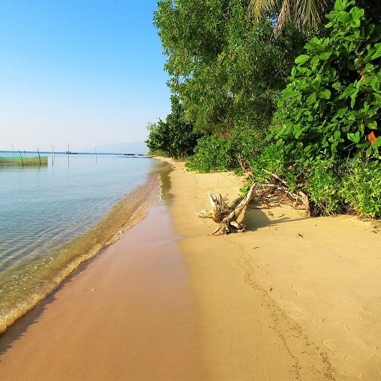
8. BÃI ÔM BEACH:
• Location: Phu Yen Province, south-central coast [MAP]
• When to go: March-September
• Getting there: nearest transport hubs for flights, trains & buses: Tuy Hoa & Quy Nhon
• Where to stay: closest good accommodation: Ocean Beach Hostel & Timothe Beach Bungalows
• Related guides: The Beaches of Phu Yen & Quy Nhon: A Guide
• Description: Near the southern tip of the Xuan Thinh Peninsula – a finger of land curling into the sea and hiding some extraordinary beaches – Bai Om is the holy grail of the entire area. A secluded beach of powdery sand perfectly pocketed between two rugged headlands and backed by coconut palms, Bai Om is so far completely undeveloped. I would imagine that, one day, Bai Om will be the jewel in the crown of Phu Yen Province, developed, no doubt, by some exclusive and astronomically-priced resort company. But, for now, it’s empty. However, sections of the bay are used as a trash dump by the local community (not to mention the litter left by day-trippers), so expect some plastic bags, glass beer bottles, and soda cans. Bai Om is accessed via small roads running along the western and eastern sides of the peninsula, but there’s no public transportation, so the beach is best visited with your own wheels: indeed, the whole region is ripe for exploration. (You can read more about Bai Om Beach in my Beaches of Phu Yen & Quy Nhon Guide.)
• Images of Bai Om Beach


9. CÂY SAO BEACH:
• Location: Phu Quoc Island, Kien Giang Province, Gulf of Thailand, off the southwest coast [MAP]
• When to go: October-May
• Getting there: daily flights to Phu Quoc Airport; daily ferries to Bai Vong Port
• Where to stay: growing range of good accommodation
• Related guides: Phu Quoc Island: North & East Coasts
• Description: Located along the central stretch of Phu Quoc Island’s east coast, Cay Sao Beach is slowly beginning to attract more visitors, ever since the East Coast Road was paved a couple of years back. Although Cay Sao doesn’t have the long sandy beaches and turquoise waters of the west coast (Cay Sao is very shallow and tidal), it does have a very appealing air of tranquility and an attractive languorous ambience that used to characterize most of Phu Quoc Island before the advent of tourism a decade ago. The southern section of Cay Sao is a sprawling, shallow bay: sometimes very pretty with large swathes of trees leading right to the water’s edge; other times a bit scruffy with fishing and building debris. The central section is the most up-and-coming part of Cay Sao Beach. This is where a cluster of lovely, small, mid-range resorts have opened up over the last year or so, thus drawing the attention of travellers. The landscape and seascape here are alluring: to the east, the water is glassy and like a mirror to the sky, while to the west the densely jungled ridges of Phu Quoc National Park rise dramatically. The northern section of Cay Sao is also starting to attract investment and visitors. A handful of smart resorts, and the relocation of Rory’s Beach Bar here, are indications that Cay Sao is set for big things in the future. (You can read more about Cay Sao Beach in my Phu Quoc Island: North & East Coasts Guide.)
• Images of Cay Sao Beach


10. CAM LẬP PROMONTORY & BÌNH TIÊN BEACH:
• Location: Khanh Hoa Province, south-central coast [MAP]
• When to go: December-August
• Getting there: nearest transport hubs for flights, trains & buses: Cam Ranh, Phan Rang, Nha Trang
• Where to stay: Escalade Resort & Dao Hoa Vang Villa
• Related guides: Cam Lap Promontory & Nui Chua Coast Road
• Description: Cam Ranh Bay, just south of Nha Trang, is a splendid natural harbour surrounded by hills. From its southern shores, a rugged horn of land projects northwards into the bay: this is Cam Lap Promontory. Accessed via a steep, narrow, paved lane leading off the spectacular Nui Chua Coast Road, Cam Lap Promontory is characterized by giant boulder piles which rise from the calm, blue waters of the bay. Despite all this rock, the entire peninsula is cloaked in foliage: eucalyptus plantations occupy the high-ground, giving way to shady groves of cashew and mango trees on the low-ground. The trees and boulders continue right to the waters’ edge, where the waves have slowly eroded the rocks into fine white sand. The eastern side of the promontory boasts a series of gently arcing bays with excellent white-sand beaches separated by giant boulders lying in the sand like unfinished sculptures (there’s even some decent coral just offshore). Sadly, the beaches and water quality have degraded in recent years, thanks to a surge is the local fishing industry (mostly lobster fishing) and general litter discarded by visitors and the local community. Nearby, Binh Tien Beach is a long and lovely stretch of sand and blue water that, despite being slated for major development for years, is still mostly empty. (You read more about these beaches in my Cam Lap Promontory Guide & Nui Chua Coast Road Guide.)
• Images of Cam Lap Promontory & Binh Tien Beach


11. MŨI YẾN CAPE & PHÚ THƯỜNG BEACH:
• Location: Phu Yen Province, south-central coast [MAP]
• When to go: March-September
• Getting there: nearest transport hubs for flights, trains & buses: Tuy Hoa & Quy Nhon
• Where to stay: some local guesthouses nearby or hotels in Tuy Hoa
• Related guides: The Beaches of Phu Yen & Quy Nhon: A Guide
• Description: At the end of a series of small, paved lanes, Mui Yen is a beautiful and very peaceful spot at the tip of a headland which almost touches Hon Yen, a rocky islet comprised of geometric volcanic rock formations. Although there’s no sandy beach, swimming and snorkeling are both good here, because the water is so clear and there’s some coral and colourful starfish in the bay. There’s something timeless and poetic about Mui Yen that has captured visitors for many years. A small shrine sits atop the sandy cape, below which a collection of Chinese-style circular tombs cluster around the volcanic rocks leading down to the sea, watched over by the black wall of rock on Hon Yen Islet. Mui Yen has a few local cafes with hammocks under tropical almond trees, where you can swing in the sea breeze, drinking a coconut while taking in the views over the picturesque coastal scene. However, if sand is what you’re looking for, just around the north side of Mui Yen Cape (accessed via more narrow lanes) is Phu Thuong Beach. Also known as Yen Beach, this is a long, gorgeous sweep of sand between two volcanic cliffs. It’s an absolutely stunning setting, and as yet there’s no development whatsoever. Lap it up while you still can, because this beach has ‘International Luxury Hotel Chain’ written all over it. The swimming is marvellous and the sea is bright blue. (You can read more about Mui Yen Cape & Phu Thuong Beach in my Beaches of Phu Yen & Quy Nhon Guide.)
• Images of Mui Yen Cape & Phu Thuong Beach


12. HANG CÂU BEACH & CLIFFS:
• Location: Ly Son Island, Quang Ngai Province, off the central coast [MAP]
• When to go: March-September
• Getting there: daily boats to Sa Ky Port; nearest transport hubs for flights, trains & buses: Chu Lai, Quang Ngai, Tam Ky & Danang
• Where to stay: local guest houses & camping near the beach
• Related guides: Ly Son Island: Travel Guide
• Description: Probably one of the most dramatically situated beaches in Vietnam, Hang Cau is a seam of white-coral sand swept beneath the giant, swirling contours of an arch-like cliff-cave. In the northeast of Ly Son Island, the surf at Hang Cau breaks about 100m offshore, where a line of reefs protects the beach from large rollers. The sea is crystal clear and the air always has a slight mist caused by the spray of the surf drifting up from the ocean and into the cave. Hang Cau is an incredibly atmospheric place and very striking: it has a somewhat mythical quality, and would make a good setting for the Scylla and Charybdis episode in Homer’s ‘The Odyssey’. However, swimming isn’t that easy because of reefs, surf and rocks. It’s fine for experienced sea swimmers, but for those who aren’t too comfortable in the ocean, it might be better to look at rather than to bathe in. (You can read more about Hang Cau Beach & Cliffs in my Ly Son Island Travel Guide.)
• Images of Hang Cau Cliffs & Beach


13. RẠCH TRÀM BEACH:
• Location: Phu Quoc Island, Kien Giang Province, Gulf of Thailand, off the southwest coast [MAP]
• When to go: October-May
• Getting there: daily flights to Phu Quoc Airport; daily ferries to Bai Vong Port
• Where to stay: nearest accommodation in Bai Thom & Ganh Dau
• Related guides: Phu Quoc Island: North & East Coasts
• Description: The most northerly beach on Phu Quoc Island, Rach Tram is also the most remote and least visited. Accessed via a newly paved road through beautiful jungle and cajeput forests, Rach Tram is a long, sandy, tree-rimmed beach with high, green hills rising behind. It’s one of the most scenic stretches of coastline anywhere on the island, and there’s no development at all, yet. That will change soon, as plans are afoot to build a large ‘eco-tourism area’ here. But, for now, if you take the rough, red-dirt lane to the northern section of Rach Tram, you’ll have the entire beach to yourself. The sea here (which is the Gulf of Thailand) is warm, shallow and calm, and the Cambodian mainland is clearly visible on the horizon. Rach Tram Beach isn’t perfect: there’s plenty of fishing-related debris on the sand and in the water, and each year more household litter washes up on the beach from the open sea. But the swimming is good, the scenery marvellous, and other travellers are nowhere to be seen. Rach Tram is great for exploring and is one of the last such places left on this rapidly developing island. Enjoy it while you can. (You can read much more about Rach Tram Beach in my Phu Quoc Island: North & East Coast Travel Guide.)
• Images of Rach Tram Beach


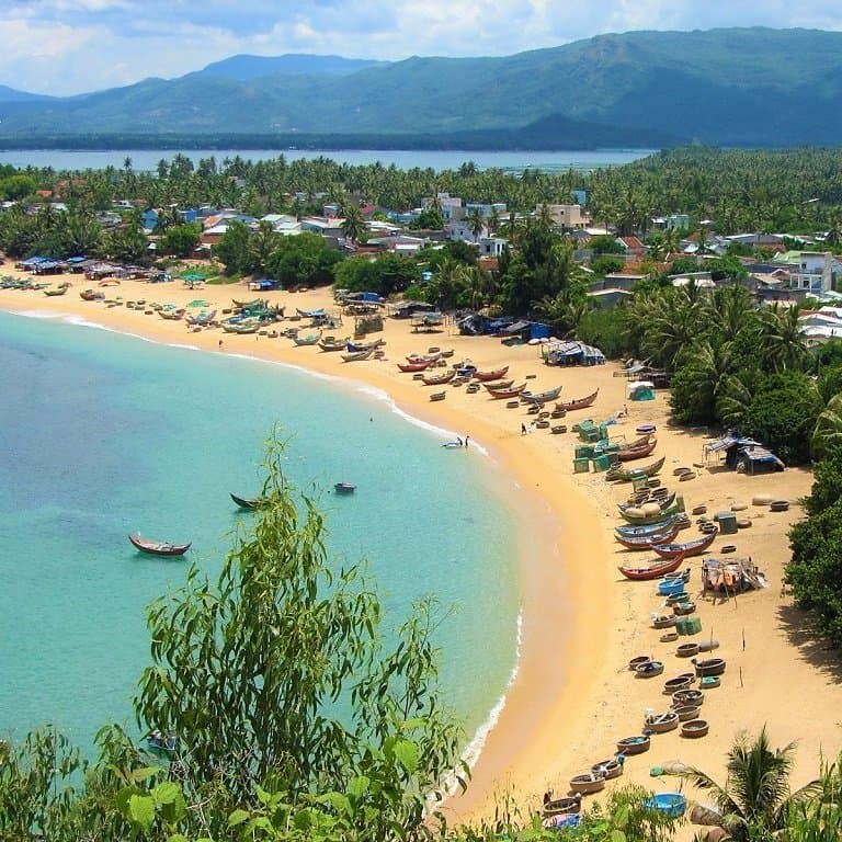
14. KỲ CO BEACH:
• Location: Binh Dinh Province, central coast [MAP]
• When to go: March-September
• Getting there: nearest transport hubs for flights, trains & buses: Quy Nhon & Dieu Tri
• Where to stay: several local guesthouses & a couple of resorts nearby: see this
• Related guides: The Beaches of Phu Yen & Quy Nhon: A Guide
• Description: One of the most talked about beaches in Vietnam over the last few years, Ky Co is a drop-dead gorgeous wedge of white sand between two giant rocky buttresses, which isolate the beach completely. Until recently, it was only possible to access Ky Co by boat, but now there is an absurdly steep and scenic road running along the clifftops before descending, almost vertically, to the beach itself. Ky Co justifies the hype it receives in the travel industry and on social media: the first glimpse of it, from high up on the cliffs, really is jaw-dropping. Already very popular with domestic tourists, the best time to visit Ky Co is between 1-3pm, when most visitors are having lunch or sheltering from the sun. The centre of the bay can get pretty busy: this is where boats come and go at the pier, photography kiosks take your picture on the sands, a restaurant serves food (and techno music), and jet skis can be rented. But stroll further down the beach, toward the southern end, and you’ll find it much more peaceful. Here, there are caverns and pretty little coves, the water is perfect for bathing, and there are showers, changing rooms, bamboo-and-thatch huts, and a couple of snack outlets. Litter is not yet a problem Ky Co, but only because staff are employed to go around constantly picking up the trash that people discard, and because the beach has a no outside food and drink policy. (You can read more about Ky Co in my Beaches of Phu Yen & Quy Nhon Guide.)
• Images of Ky Co Beach


15. HÒN GỐM SANDBAR:
• Location: Khanh Hoa Province, south-central coast [MAP]
• When to go: March-September
• Getting there: nearest transport hubs for flights, train & buses: Tuy Hoa, Dai Lanh & Nha Trang
• Where to stay: several local guesthouses nearby
• Related guides: Hon Gom Sandbar: Travel Guide
• Description: Stretching thirty kilometres into the East Sea, like a giant causeway to a sunken castle, Hon Gom Sandbar (also referred to by other names) is a deserted, rocky and beguiling peninsula two hours north of Nha Trang, on the south-central coast. A long and rugged finger of land pointing southwards into the ocean, its eastern side is characterized by miles of empty, exposed, wild and windy beach, while, on its western side, fish farms and fishing hamlets shelter in peaceful, protected coves, where the water is as calm as a lake. A wide new road has been constructed along most its length, paving the way for future development. But, for now, the road is as empty as the beaches either side of it. There are several good beaches and bays on Hon Gom Sandbar, including Hon Ngang (a long, sandy beach stretching along the north and east of the sandbar), Hon Ghenh and Xuan Dung (both beaches near the centre of the sandbar), and Mui Doi Cape (at the tip of the sandbar, and Vietnam’s most easterly point). You’ll need your own wheels to really explore the beaches, bays and coves here, and some are only accessible on foot. Predictably, trash is becoming a big problem on the sandbar. But, in general, the water quality is good and the swimming excellent, unless you happen to visit during high winds, of course. (You can read more about these beaches in my Hon Gom Sandbar Travel Guide.)
• Images of Hon Gom Sandbar


16. TAM THANH BEACH:
• Location: Quang Nam Province, central coast [MAP]
• When to go: April-September
• Getting there: nearest transport hubs for flights, trains & buses: Danang, Hoi An, Tam Ky (Chu Lai)
• Where to stay: Tam Thanh Beach Resort, AnnaBo Beach House, Tam Thanh Natural Beach Resort
• Related guides: The Coast Road: Saigon to Hoi An
• Description: The central section of an almost unbroken beach stretching from Tam Hai Island in the south to the Cua Dai Estuary in the north, Tam Thanh is an up-and-coming little beach retreat. Within easy reach of Hoi An, Danang, and Tam Ky, Tam Thanh is a long and sandy beach backed by casuarina trees with wide ocean vistas and several interesting places to stay. Part of Tam Thanh’s appeal is the acres of space and lack of crowds: tourism in this area has long focused on Hoi An and Danang, leaving the coastline around Tam Thanh relatively undeveloped. But that’s starting to change, as investors realize the potential of Tam Thanh. For now, however, the beach is often empty, save for dozens of beautifully-made woven fishing canoes pulled-up on the sand. Tam Thanh is also one of several coastal villages where colourful murals have been painted on village buildings as a way of attracting visitors, but also to highlight local issues, such as litter and the environment. There is a lot of empty sand to tread and sea to swim in along this stretch of coast.
• Images of Tam Thanh Beach


17. BÃI RẠNG BEACH:
• Location: Phu Yen Province, south-central coast [MAP]
• When to go: March-September
• Getting there: nearest transport hubs for flights, trains & buses: Quy Nhon, Dieu Tri
• Where to stay: good nearby options: see this
• Related guides: The Beaches of Phu Yen & Quy Nhon: A Guide
• Description: A small crescent of toast-gold sand lined with coconut palms and squeezed between two rocky bluffs topped with tropical foliage, Bai Rang Beach is a pretty little spot located just off the main road, 15km south of Quy Nhon. The coastline in this part of Phu Yen Province is a complex mix of rocky coves, outcrops, and fingers of rugged land that meet ocean like a spread hand, between which crescents of white sand create perfect secluded beaches, of which Bai Rang is just one of many. But I prefer Bai Rang above the other beaches here, because it’s still a working beach with a local fishing community, and only low-key tourist infrastructure: a couple of informal seafront eateries with hammocks and showers is all that graces the sand. The swimming is good and there’s even some modest coral in the bay; the water is shallow enough to feel safe and the bay is sheltered so it’s generally calm; the beach is fine, golden sand with some rocky outcrops at both ends; casuarina trees grow at one end of the bay, giving way to coconut palms at the other; coracles, nets and other fishing paraphernalia are drawn-up onto the sand and a clutch of blue-painted wooden fishing boats moor offshore. (You can read more about this beach in my Bai Rang Beach Guide.)
• Images of Bai Rang Beach


18. ÔNG LANG BEACH:
• Location: Phu Quoc Island, Kien Giang Province, Gulf of Thailand, off the southwest coast [MAP]
• When to go: October-May
• Getting there: daily flights to Phu Quoc Airport; daily ferries to Bai Vong Port
• Where to stay: Mango Bay, The Shells, Island Lodge, Coco Palm Resort, Sea Sense & more here
• Related guides: Phu Quoc’s Beaches: A Guide
• Description: A long stretch of lovely, sandy bays punctuated by slabs of black, volcanic rock, Ong Lang Beach is situated on the central northwest coast of Phu Quoc Island. More of a chain of connected mini-bays than a long, unbroken beach, Ong Lang is peaceful, calm, green, and serene. The swimming is good, the water is generally clean, and there’s even some OK snorkeling just offshore. The beach, which is backed by coconut palms and casuarina trees for most of its length, turns to fertile red earth just a few metres inland from the sea, where tropical gardens, fruits orchards, and exotic flowers grow in abundance. In the shade of all this foliage, a network of narrow paved lanes is now a thriving tourist enclave, featuring boutique resorts in all price-brackets, organic-produce shops, hipster cafes, smooth bars, and Western restaurants. But, unlike other popular beaches on the Phu Quoc Island, most of the development here has been low-rise and, occasionally, low-impact. Just as everywhere else on the island, Ong Lang has grown enormously in popularity over the last few years. But, somehow, it retains a low-key atmosphere, and remains an extremely attractive place to stay for a few days. Whether you’re a family, a couple, or a group of backpackers, Ong Lang Beach has got you covered. The general level of accommodation across all budgets is excellent. (You can read more about Ong Lang Beach in my Phu Quoc Beaches Guide.)
• Images of Ong Lang Beach


19. NINH VÂN BAY & DỐC LẾT BEACH:
• Location: Khanh Hoa Province, south-central coast [MAP]
• When to go: March-September
• Getting there: nearest transport hubs for flights, trains & buses: Nha Trang & Ninh Hoa
• Where to stay: Six Senses, Ninhvana Backpackers, An Lam Retreats, L’Alya Resort, Jungle Beach, Wild Beach, Some Days of Silence
• Related guides: The Coast Road: Saigon to Hoi An
• Description: An hours’ drive north of Nha Trang lies a chubby peninsula whose forested mountains give way on both sides to gorgeous bays, beaches, coves and lagoons. On the north side, a series of long, arcing beaches front the beautiful and serene waters of Van Phong Bay. Doc Let Beach, at the northeast of the peninsula, features long, white sands and calm seas, that are best experienced at Some Days of Silence or camping near the beach. Further south, beyond the Hyundai shipping port, is another wonderful bay, which has become known as ‘Jungle Beach’ after the success of the eponymous backpacker retreat at the centre of the bay. (Although Jungle Beach has changed hands from the original owners, it’s still in operation). Right at the southern tip of the peninsula, Ninh Van is the kind of sleepy fishing hamlet one wished there were more of in Vietnam. This peaceful spot is now home to the excellent NinVana Backpackers Hostel. Ninh Van village is the end of the road, but, around the western side of the peninsula, are three extremely luxurious resorts, famed throughout Vietnam: Six Senses, An Lam Retreats and L’Ayla. Only accessible by private boat, you’ll need to splash out to stay here, but you’re unlikely to be disappointed.
• Images of Ninh Van Bay & Doc Let Beach


20. LIÊN HƯƠNG BEACH:
• Location: Binh Thuan Province, south-central coast [MAP]
• When to go: December-May
• Getting there: nearest transport hubs for trains & buses: Mui Ne, Phan Thiet, Lien Huong
• Where to stay: local guesthouses in Lien Huong, or resorts in Mui Ne
• Related guides: The Sand Dune Highway: Mui Ne to Ca Na
• Description: A terrific stretch of sand and sea running for about 10km, Lien Huong Beach is seldom visited by foreign travellers, who congregate instead at nearby Mui Ne. Unlike Mui Ne, Lien Huong Beach has practically no tourist infrastructure at all; however, an excellent road leads along its entire length with easy access to kilometres of empty beach. Between the road and the beach, small sand dunes lie in the shade of whispering casuarina trees. The sand is powdery, fine, and white, and the ocean is blue and shallow. It’s a lovely, long beach that’s great for a swim and a picnic. But, sadly, Lien Huong Beach has suffered terribly in the last few years from picnickers neglecting to take their rubbish away with them: plastic bags, empty beer cans, and polystyrene boxes have completely ruined much of this amazing stretch of coast. Nonetheless, with your own wheels, you should still be able to find an unspoiled section. (You can read more about Lien Huong Beach in my Sand Dune Highway: Mui Ne to Ca Na Guide.)
• Images of Lien Huong Beach


21. AN BÀNG & MỸ KHÊ BEACHES:
• Location: Danang & Quang Nam Provinces, central coast [MAP]
• When to go: April-September
• Getting there: nearest transport hubs for flights, trains & buses: Danang & Hoi An
• Where to stay: lots of good options for all budgets along the coast between Hoi An & Danang
• Related guides: The Coast Road: Saigon to Hoi An
• Description: Between Hoi An and Danang, on the central coast, stretches 30km of unbroken beach. Although, technically, this is one, long bay, in reality the beach is divided into sections and given different names. You could choose any part of this long beach, but An Bang (near Hoi An) and My Khe (near Danang) are particularly pleasant sections. The former has a trendy, vaguely hipster vibe, with bars selling craft beer, boutique resorts, Western restaurants, cool cafes, and an expat enclave. But, most importantly, the sand and sea here is excellent (although coastal erosion is a growing concern). My Khe is essentially the municipal beach of Danang, which is currently one of the most exciting and appealing cities in Vietnam. These days, My Khe is backed by dozens of high-rises hotels and Danang’s increasingly impressive skyline. The beach, which is wide and sandy, is kept very tidy. There’s a seafront walkway under palm trees, deckchairs, beach sports, bars, and cafes. The surf on My Khe is meant to be some of the best and most reliable in Vietnam. In any case, there’s always a certain buzz about this beach, as there is about Danang.
• Images of An Bang & My Khe Beaches


22. BÃI NHỎ BEACH:
• Location: Phu Quy Island, Binh Thuan Province, off the south-central coast [MAP]
• When to go: December-April
• Getting there: daily ferries from Phan Thiet
• Where to stay: good local guesthouses & mini-hotels nearby: see this
• Related guides: Phu Quy Island: Travel Guide
• Description: At the southeastern tip of Phu Quy Island, way out in the East Sea, Bai Nho Beach is accessed via a steep, grassy pathway leading down from the coast road. The beach is a slice of white sand and black rocks in the shadow of the enormous Phu Quy Flagpole. The coast here is weather-beaten and barren: the exposed bluffs are treeless, covered in a heather-like brush. The water is clear and bright-blue where the white sand slides under the surf, but out in the bay it becomes bruised where large submerged rocks lurk beneath the swell. The sunshine brings out the vibrant tropical colours of Bai Nho Beach; but when overcast, the coastline takes on a bleak, Hebridean quality. I find it a compelling spot: not only for swimming in the lovely water (although it can get very rough and dangerous at times), but also for hiking along the rugged cliffs that stretch either side of the beach. Great volcanic escarpments, with swollen ruptures and gaping fissures, meet the sea where an old military bunker keeps a look out. Litter on Bai Nho Beach is in the form of a crust of flotsam and jetsam consisting of polystyrene and fishing equipment washed up from the wider ocean, but it’s generally bearable. There’s rarely anyone here on weekdays, but weekends see a flurry of domestic day-trippers. (You can read more about Bai Nho Beach in my Phu Quy Island Travel Guide.)
• Images of Bai Nho Beach


23. HỒ TRÀM & HỒ CỐC BEACHES:
• Location: Ba Ria-Vung Tau Province, south coast [MAP]
• When to go: November-May
• Getting there: bus, taxi, hired vehicle or private wheels from Vung Tau or Ho Chi Minh City
• Where to stay: Ho Tram Beach Boutique Resort, camping & other options
• Related guides: Ho Tram & Ho Coc Beaches: A Guide
• Description: Only a couple of hours’ drive east of Ho Chi Minh City, the beaches of Ho Tram and Ho Coc are the best stretches of sand and sea available within easy reach of Vietnam’s largest city. Ho Tram and Ho Coc may not be the prettiest beaches on this list, but their proximity to the southern commercial hub and an increasing range of accommodation options, make them very convenient for city dwellers looking for a quick mini-break by the sea. Ho Tram Beach boasts over ten kilometres of fine sand backed by casuarina trees. To the west of the beach, a long sandbar, formed by the Ray River, is a scenic location, with the East Sea on one side and the river and mangrove forest on the other. Ho Tram Beach is fast becoming a high-end retreat for wealthy Saigon residents: by far the best accommodation is Ho Tram Boutique Resort, which also features the best-kept stretch of sand. Ho Coc, which is the next beach east of Ho Tram, is an arc of light-coloured sand backed by densely jungled hills. On a clear day, the curving bay, blue sea and green hills are very picturesque. Accommodation options in Ho Coc are generally cheaper than Ho Tram. Swimming in Ho Coc is marginally better than Ho Tram, but both beaches have strong currents and the water quality varies according to the season. (You can read more about these beaches in my Ho Tram & Ho Co Beaches Guide.)
• Images of Ho Tram & Ho Coc Beaches


Disclosure: I never receive payment for anything I write: my content is always free & independent. I’ve written this guide because I want to: I like these beaches & I want my readers to know about them. For more details, see my Disclosure & Disclaimer statements here
[Back Top]


Unfortunately number 3 on this list – Bai Trang beach now closed to the public
Fenced off with security on site
Shame. Glad I got to visit it in 2024
Hi Seamus,
Thanks for the update. That is very sad, but also inevitable, I guess. Let’s hope that whatever they are doing with the beach, it will remain beautiful.
Best,
Tom
Tiếc là Lang Co beach chưa có mặt trong trang này?
Hi Trần,
Yes, I like Lăng Cô beach, too. But, it’s not quite good enough at the moment to make it on to my personal list of these 23 beaches.
Best,
Tom
Dear Tom
so envious of all the beautiful and amazing places you have been to.
and you write sooooooo much detail. quite amazing – and time consuming. thank you soooo much for your time and huge effort to help others to find and enjoy.
we live in TP Can Tho now, but travel anywhere was wrecked by the very lengthy lock-down (and my wife is still paranoid), and our now even more restricted budget after some comparatively heavy expenses.
from CT, where would you head for a week-ish holiday? Can Dao? or Phu Quoc? or some other place out of Rach Gia?
and exactly where would you recommend to stay?
warmest regards
don
Hi Don,
Thanks for your kind words.
Yes, I would head to either Con Dao or Phu Quoc – they are both great places to spend a week. Which one you choose depends on what you’re looking for and on time of year. The Con Dao can be windy and rough until March – conditions should get better from April. Phu Quoc is best from November to May.
Con Dao is very quiet, natural, relatively undeveloped, rugged and wild; it’s also very small. However, this also means there are far fewer choices for accommodation and not so many things to do.
Phu Quoc is much bigger and more developed, so there’s a much bigger range of accommodation to choose from and lots of activities.
I hope this helps,
Tom
Hello Tom!
Thank you for making us dream but now we are facing a dilema 🙂 . We dont have enough time to visit all these awesome places. If we had to make a choice between Con dao Island and Cam ranh what would you advise us?
Thank you!
Elsa and Mael
Sorry, I forgot to mention that we will be there by the end of december/beginning of january and we like wild landscape 🙂
Thank you
Hi Elsa & Mael,
They are both great places, but I think Con Dao has the edge, especially if you like wilder landscapes. If you haven’t already, see my full Guide to the Con Dao Islands.
I hope this helps,
Tom
Hi tom!
Thank you vey much for your advice! 🙂
We have heard a lot about sand flies. Is it a big problem there?
Hi Elsa,
It depends which beach you are going to and at what time of year.
Tom
Oh my God! You went to Quy Nhon but haven’t mentioned Hòn Khô (Khô island) or Kỳ Co beach? You missed the best of Binh Dinh province, haha
Hi Tuan Anh,
Thanks. Yes, I’ve been to Hon Kho and Ky Co. Ky Co is on my map of the Coast Road from Saigon to Hoi An. I agree, they are both very nice places with great beaches.
Tom
Hi Tom,
Your website has been great while we’ve been travelling through Vietnam, thank you!
Our favourite place on the coast was Nhon Hai fishing village not far from Quy Nhon, there’s a new hostel just opened up on the beach there and the people are so lovely and the sea was the best we had for swimming and snorkelling. It would be good to keep it a secret but it’s too nice not to share! It’s well worth the detour to stay for a few days off the main roads!
Hi Rachel,
Thanks for sharing that – it sounds great and I’ll check it out next time I’m in the area. I’ve been planning to write more about Quy Nhon and the surrounding beaches for ages now.
Great to hear that you have enjoyed travelling through the country,
Tom
Is it possible to camp at any of the beaches around Quy Nhon City or Binh Đinh?
Cheers!
Nathan
Hi Nathan,
Yes, it is. But when I’ve camped in those areas it’s just been ‘wild’ camping: I find a nice spot near the beach, where I’m not visible from the road so as not to attract attention, and pitch my tent for a night. There’s a lot of talk about camp sites springing up in that area, though. So perhaps you’ll find some official campgrounds too. It’s a lovely area, and great for exploring.
Enjoy!
Tom
Mark – this is a gem of a website, I am so happy we found it. Once we figure out an itinerary for our weeklong to 10 days trip to the South, we will use your site to book accommodation to support the site. We will be travelling to HCMC a few days before tet officially takes off next month. These beach descriptions are fantastic.
I am wondering which of these 7 beaches (excluding phi quoc beaches) you might recommend for two of us who will not be travelling using motorbike (we may use motorbike when we arrive, but not to and from the city to the coast, where we hope to arrange other transport).
We are a little concerned about travelling on and around Tet and hope to do a bit of the coast and if possible a bit of the deep delta, plus mountainous area + HCMC. If we can work with you in any way independently to develop an itinerary that would be amazing.
Many thanks, Anna
Hi Anna,
Thanks, it’s great to hear that you like my site.
Yes, everything gets extremely busy during Tet, but if you are travelling just BEFORE Tet (which I think is on Jan 28 this time) then you should be fine 🙂
Try Cam Lap and Ninh Van beaches in this list – they are both beautiful and secluded. You can arrange transport to both of them from Nha Trang and there are a few places to stay on both beaches. Once you’re there, you could rent a motorbike to explore the area, which is very quiet.
If you have more questions about your itinerary you can also email me: vietnamcoracle@gmail.com
And, yes, that would be great if you could support the work I do by booking your hotels through this site.
I hope this helps,
Tom
Hi Tom thanks for your great tips.
We are a couple and currently in dalat, we have a few days before getting back hone from Saigon, we would like to get to 3 days in a beach around, i saw that from the list you mentioned only Cam Lap is an option, but i cant find any information about hotels in this beach.
do you have any information redarding to some stay for budget room? i found one resort but its above 100 dollar per night..
We will be happy to get any other nice and quiet beach around…
we heard about Mui nhe but i heard that its dirty beach..
thanks a lot
cheers
Hi Alon,
Yes, you could go down to Cam Lap. That little promontory is a lovely spot. You can stay at Dao Hoa Vang – there are good dorms for 120,000vnd or rooms too, or stay at Bai Binh Chau – they have rooms for about 400,000vnd or you can rent tents on the beach there, or you can stay at Sao Bien – they have small huts on the beach for 500,000vnd.
I haven’t written a dedicated guide to this area yet, but you can find a bit more information about it (including contact information for the places to stay) in this guide.
I hope this helps,
Tom
Hi ! thanks for your fast reply and thanks for the information.
do you recommend for us to go to Cam Lap or maybe try Mui ne? what is the best option for tasting the good side of vietnam beaches for only 2 days?
Hi Alon,
If you have motorbikes and you like getting off the beaten track, definitely go to Cam Lap. If you’re taking public transport and you like a few more creature comforts, go for Mui Ne. Bear in mind that both beaches will be a little bit busier than usual, because it will be the weekend 🙂
Tom
Hi! thanks again.
we decided to take an easyrider tour of two days to Nha trang, and stay twi nights in Nha trang, where is the best to stay in nha trang area? where is the beat beach with budget hotel?
Hi Alon,
There are so many hotel options in Nha Trang that I can’t really help you there. Take a look at the budget places listed here to get an idea of what’s available.
I hope you enjoy the beach,
Tom
Hey Tom,
After exploring Saigon with your help, we also did some beach hopping south of Quy Nhon City. We had planned to ride bicylces along this stretch, but pleased we changed those plans when we saw the hills. Note to self to master a motorbike before our next visit!
Had a beautiful stay at Bai Xep beach at a place called Life is a Beach – well worth a look in if you are in that area next time. Its quite close to tbe Avani Resort, but more unique and affordable. Located along side, and quite connected with the local fishing village.
Once again thanks for the info that led us to explore this area, otherwise it would never have been on our radar, and our trip would have been tbe poorer witnout these experiences,
Regards,
Cathy
Hi Cathy,
Oh that makes me want to go back to Quy Nhon now! 🙂 Yes, I know Life is a Beach, but I’ve never had time to get to know it properly – I’ll make sure I do next time I visit. Thanks for the tip.
Glad to hear that you enjoyed exploring these beaches, especially now before they are developed.
Tom
you suck!! jokes… your awesome
You better hurry if you want to see Vung Ro. The world’s largest oil refinery is being built a few km from there and a city to house the 8,000 workers (in Vung Ro Bay) is in the works.
Thanks, Mark. Yes, I read about the development of Vung Ro Bay last week. I heard the Rockefeller family are part of a new development that will consist of an integrated resort, hotels, apartments and marinas! I’m glad I had the chance to see and swim in the bay these last few years before the development started 🙂
Don’t believe what you read in the press. It will not be some kind of beautiful integrated resort community. It will be housing for oil workers and the industries that support the oil refinery. Throw in a huge upgrade to the cargo port and you’ll see that Vung Ro Bay will become another Vung Tau.
I agree, Mark. Personally, the prospect of a gigantic Rockefeller-funded integrated resort on Vung Ro Bay sounds bad enough!
THANK YOU for all of that! Your blog is awesome!! You give so much good infos with great details. Last week, with my boyfriend, we did the beach hopping near Quy Nong and like you, we really liked Bai Rang beach. I think we wouldn’t have find it without your blog. The weather was not so nice, but the damatic sky made really good pictures!
Tomorrow we will do the ride outside Mui Ne. We’re really looking forward to it because there nothing like escaping the crowds on your motorbike! Your directions will be so usefull because when it’s the first time you visit one place, it´s not always easy to find the great spots.
I also took many notes of all the cafés and food you are recommanding in Saigon. We’ll be there for 10 days for Tet, so we will definitly have time to try some of them. Your entry about the snails in particular made me very happy! I’ve wanted to try those since Hanoi but was a bit intimidated because I had no idea how they were cooking them and what to ask for. Now, all the translations are in my notepad, so I’ll be able to ordre and know what I eat!
Thanks again, you are doping a terrific job. I think in Vietnam it’s pretty easy to feel like you’re in a herd, but with blogs like yours, there is absolutely no reason to be a part of that!!
Hi Dominique,
Thanks for your comment, I very happy my blog has been so much help to you on your travels through Vietnam. It’s great that you’ve got on a motorbike and traveled to some of the lesser known and little visited places in Vietnam. Good luck in Mui Ne and I hope you find some delicious street food in Saigon – there’s lots to choose from! 🙂
I traveled to some beaches along Vietnam, but never been in these beaches :(. Your information is very useful, I would like to try at least one of these beaches in the near future :). Uncle Tom, you are amazing 🙂