
Last updated December 2024 | Words and photos by Vietnam Coracle | 154 comments

Tom Divers is the founder and creator of Vietnam Coracle. He’s lived, travelled and worked in Vietnam since 2005. Born in London, he travelled from an early age, visiting over 40 countries (he first visited Vietnam in 1999). Now, whenever he has the opportunity to make a trip, he rarely looks beyond Vietnam’s borders and his trusty motorbike, Stavros. Read more about Tom on the About Page, Vietnam Times and ASE Podcast.
Limestone Karsts & Bamboo Forests on the Viet-Lao Border
[Get the complete Offline Guide & Map Package for $15]
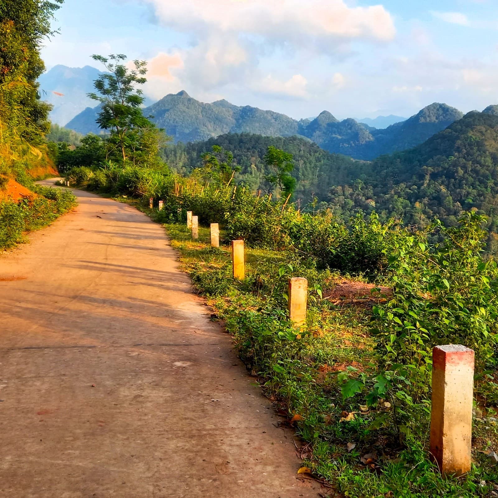
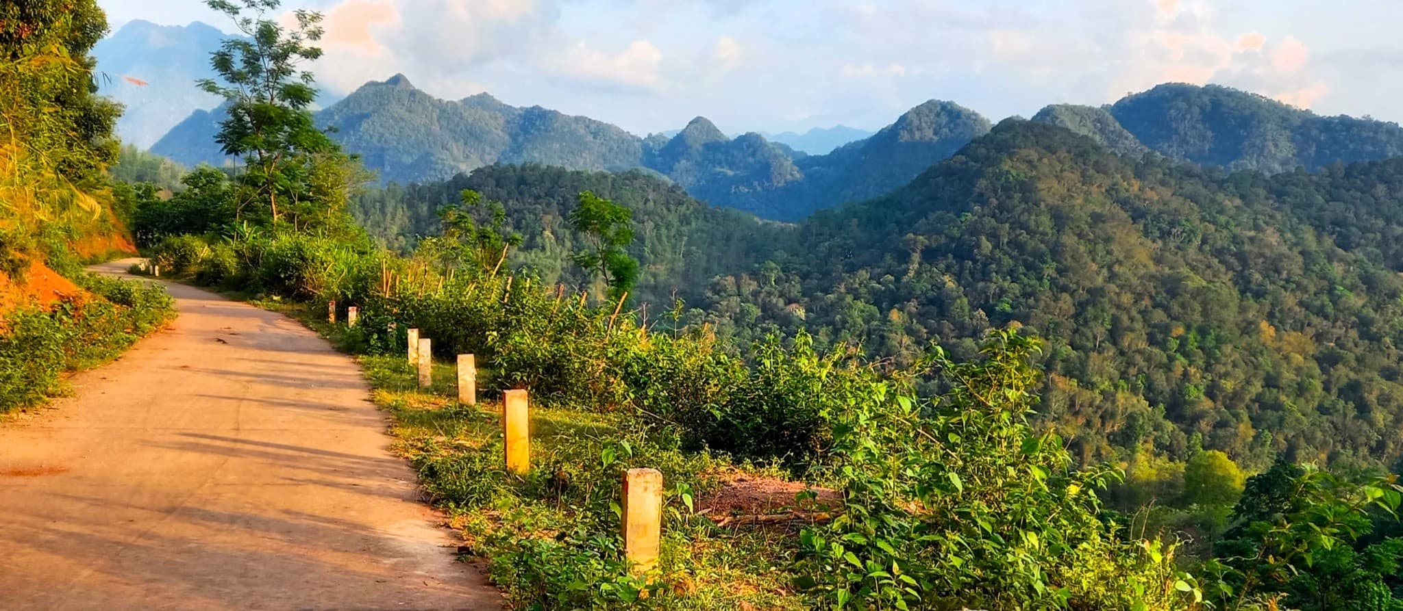
Just a few hours southwest of Hanoi is a landscape of soaring limestone mountains cloaked in bamboo forests and bisected by blue streams. The region’s most important geological feature is the mighty Mã River, a viscous, velvety body of water snaking through the karst mountains all the way from Laos. Quiet roads meander along steep valleys and mountain passes twist skyward toward remote Lao border crossings forming a network of spectacular riding roads. Straddling both Thanh Hóa and Hòa Bình provinces, the Limestone Loops consist of four separate, stand-alone motorbike loops, each of which can be ridden in one day on the road. Base yourself in Pù Luông or Mai Châu for a few nights and ride one loop each day and you’re guaranteed to fall head over heels for this region.

[Back Top]
LIMESTONE LOOPS
4 Loops through Karst Scenery near the Vietnam-Laos Border
In this guide, I’ve outlined 4 different loops, all starting/ending at Bản Đôn village, at the heart of Pù Luông Nature Reserve. Each loop is designed to be ridden separately in one full day on the road. Base yourself at one of the many excellent accommodation options in Pù Luông (or Mai Châu, if you prefer) and ride one loop each day over the course of several days. (Or, if you want, you can combine all 4 loops to create one big loop, staying at various places along the way.) I have made separate maps for each of the 4 loops, as well as a map outlining route options between Hanoi and Pù Luông. The best time of year is March-May and September-October. Click an item below for details and maps. If you enjoy this guide, please make a donation or consider purchasing the Offline Guide & Map package.

CONTENTS:
ROUTE 1: Spice Hills Loop
ROUTE 2: Cascades Loop
ROUTE 3: Lao Loop (south)
ROUTE 4: Lao Loop (north)

Support My Work
Free | Independent | No Sponsored Content
“Hello, if you enjoy my website, please support it.
Thank you.” Tom
ROUTE MAP:
Limestone Loops | 4 Motorbike Routes
[Get the complete Offline Guide & Map Package for $15]
MAP LEGEND:
- Blue line: Spice Hills Loop
- Red line: Cascades Loop
- Purple line: Lao Loop (south)
- Orange line: Lao Loop (north)
*Road Safety & Disclaimer: Riding a motorbike in Vietnam – or anywhere in the world – has its dangers. I would hope & expect anyone who chooses to pursue a self-drive road trip based on the information on this website does so with care, respect & due diligence. I encourage careful riding & adherence to road rules, but I am not responsible for the legality or manner in which you ride, nor any negative consequences which may result from your decision to ride a motorbike in Vietnam: you do so at your own risk. Read more >

About the Loops:
Below is a brief at-a-glance overview of the Limestone Loops, followed by more specific details about important considerations, such as start/end points, accommodation, road conditions, traffic, food and drink, weather, connecting routes and more:
QUICK DETAILS:
- Route: 4 loops through limestone karst scenery around the Mã River valley, Pù Luông Nature Reserve & the Lao border
- Distance: 805km (all 4 loops combined)
- Duration: 4-6 days
- Scenery: limestone karst mountains, bamboo forests, rivers, caves, jungles, valleys, borderlands
- Attractions: caves, waterfalls, river swimming, villages, historic sites, bamboo waterwheels, scenic passes
- Road Conditions: good paved roads & narrow back-roads, light traffic, some rough patches
- Best Time: March-May, September-October
[Get the complete Offline Guide & Map Package for $15]
Getting to/from Hanoi: Although some riders will connect to the Limestone Loops from elsewhere, most people will likely be coming from Hanoi. I have written a separate section about this, including a route map: see below for details.
Start & End: Each of the 4 loops in this guide start and end at Bản Đôn village, located at the centre of Pù Luông Nature Reserve, where there are lots of great accommodation options (see my guide to Pù Luông Nature Reserve for details). The loops are designed to be ridden one by one, starting and ending each day from your base in Pù Luông. Personally, I can’t think of a better way to enjoy these motorbike loops than to begin each day with breakfast overlooking the rice terraces of Pù Luông, followed by several hours on the road exploring the loops, and arriving back in Pù Luông for a delicious local dinner (and perhaps a cocktail) watching the the sun set behind the limestone mountains. However, if you prefer, you can easily shift the daily start/end point of each loop to nearby Mai Châu (a lovely valley where there’s lots of good accommodation), or even tackle all 4 loops in one, staying at a different place each night. It’s up to you, but my recommendation is to find a good place to stay in Pù Luông and start/end each day and each loop there over the course of 4-7 days. This is a wonderful way to experience the region.
Using the Maps: This guide includes 6 separate maps: x1 showing all 4 Limestone Loops; x1 showing route options to/from Hanoi; and x1 map for each of the 4 individual loop: Spice Hills Loop, Cascades Loop, Lao Loop (south), Lao Loop (north). If you purchase the Offline Guide & Map you will receive pre-downloaded KMZ files for all 6 maps. If not, you can find all 6 maps imbedded in the relevant sections of the guide on this page.

Distances: The combined distance of all 4 loops is 805km, but the average distance of each individual loop is around 200km. See each loop for exact distances, maps and details.
Duration: I recommend riding one loop per day. As there are 4 loops, this would mean spending 4 days to complete all the Limestone Loops. However, you could easily spend up to 7 days riding the loops, especially if you choose to take some of the optional side routes and detours on my maps. Riders in a rush could complete the loops in as little as 2-3 days by combining some of the loops: for example, the two Lao Loops could be condensed into one Lao Loop. Bear in mind that the roads are winding and mountainous, making average speed relatively slow, and the scenery is so good that you will want to stop regularly to enjoy it. It is best to plan to spend a full day riding each loop.
Connecting Routes: The Limestone Loops link seamlessly with other excellent routes in the region, offering riders the chance to extend their road trip. These include, the Lam Sơn Loop, the Mường Lống Loop and the Ghost Road, as well as connecting to the Ho Chi Minh Road to the east.
Traffic & Road Conditions: There’s only light traffic on all of the loops: in some cases, there are hardly any other vehicles whatsoever. However, trucks do ply the roads leading to the Lao border as trade between the two neighbouring communist nations is booming. Most of the roads – even the smaller back roads – are in pretty good condition: all paved, all rideable on any kind of motorbike. At the time of latest update, there were a few bumpy sections here and there, but nothing much to worry about, unless there’s been very heavy rainfall, in which case road conditions could deteriorate.
Gas Stations: There are gas stations at fairly regular intervals on all of the loops. However, some regions, especially the western areas towards the border with Laos, are quite sparsely populated and places to fill up are few. If riding one loop per day, most motorbikes will need to stop for gas once on each loop (assuming you start the day will a full tank). Most villages and towns marked on my maps with a red pin will have at least one gas station. But don’t let your fuel gauge get too low before looking to fill up.

Weather & Time of Year: Although it’s possible to ride the Limestone Loops at any time of year, the best time for weather conditions and scenery is spring (March-May) or early autumn (September-October). During the high summer months (June-August) it can be very hot with some heavy rainfall. In the winter (January-February) it can be surprisingly cold and grey, especially on the high mountain passes..
Accommodation: I highly recommend choosing an accommodation in Pù Luông or Mai Châu and using it as a base from which to ride the loops in this guide. Both Pù Luông and Mai Châu have lots of excellent places to stay in all price ranges. Find an accommodation that suits you and use that as your hub from which to explore the wider region by riding one loop per day. If not, there are a handful of local guest houses (nhà nghỉ) in most villages on the loops, as well as some homestays scattered here and there, such as Thác Mu and Thác Mây on the Cascades Loop. Note that at the time of research, foreign travellers were not allowed to stay overnight in the town of Mường Lát, on the Lao Loop (North)
Food & Drink: Assuming that most riders will base themselves in Pù Luông or Mai Châu, the only meal you’ll be having on the road is lunch, and perhaps a snack or two. Most villages and towns on the loops have local cơm-phở (rice-noodle) eateries. If you want a proper meal, you’ll need to stop at the right time of day: lunch usually starts around 11am and is over by 1pm. Drinks and snacks are available at regular intervals from local stores. For breakfast and dinner, both Pù Luông and Mai Châu have lots of excellent places to dine.
[Get the complete Offline Guide & Map Package for $15]


Getting from/to Hanoi:
[Get the complete Offline Guide & Map Package for $15]
If you want to start the road trip from Hanoi (rather than renting a motorbike in Pù Luông or Mai Châu), there are several potential routes to take from the capital. Although both Pù Luông and Mai Châu are less than 200km southwest of Hanoi, the ride can take between 4-6 hours, depending on weather, traffic, road conditions and which route you choose to take. Personally, I don’t really enjoy the ride from Hanoi, especially the first hour or two, which involves negotiating the capital’s clogged streets and then the truck-strewn industrial suburbs. However, this miserable urban sprawl serves are a remarkable juxtaposition to the beautiful natural setting of Pù Luông and Mai Châu. On my map below, I’ve marked two possible routes from Hanoi: main roads (blue line) and back-roads (red line). Both routes are the same distance at 195km. The main roads route is easier to navigate and the roads are bigger and wider, but there’s more traffic. The back-roads route utilizes quieter roads, passing more appealing scenery, going more off the beaten path, but there are still a couple of unpleasant sections and the possibility of minor road deterioration. Another option is to combine the two routes using various link roads. Personally, if the weather is good and time isn’t an issue, I would choose the back-roads route; if the weather is grim and all you want to do is get the ride over with, I would choose the main roads route. (For information about how to get from Hanoi to Pù Luông by bus, see my Pù Luông Nature Reserve Travel Guide.)
ROUTE MAP: Hanoi to/from Pù Luông (Bản Đôn village)
- Blue Route: main roads | 195km
- Red Route: back-roads | 195km


Route 1: Spice Hills Loop
[Get the complete Offline Guide & Map Package for $15]
QUICK DETAILS:
- Route: Pù Luông→Lũng Vân→Pù Bin→Mai Châu→Cun Pheo→Co Lương→Pù Luông
- Distance: 155km
- Duration: half or full day
- Road Conditions: good back roads, a few rough patches
- Scenery: valleys, rice fields, misty mountains, high passes, limestone peaks, villages
- Attractions: caves, villages, views, wonderful scenery, back roads, good riding
ROUTE MAP: Spice Hills Loop | 155km
Description: The Spice Hills Loop can be ridden in either direction, but I prefer to go anti-clockwise on the loop. Heading south from Bản Đôn village and enjoying the views from the road across the misty valleys of Pù Luông Nature Reserve, the route sweeps northwards from the Làng Tôm intersection and on through Phố Đoàn village where the market is worth a stop if it’s early morning. Veering eastward, the road ascends an incredibly steep pass zigzagging up a sheer wall of limestone, affording panoramic views of the valley from each hairpin. Perched on a bend, a săn mây (‘cloud hunting’) cafe is a favourte spot for photographers to come in the early mornings when a mist lingers in the valley. The pass summits and cuts through a valley of limestone peaks before cruising across the Lũng Vân plateau. Turning due northwest at Lũng Vân village, the back road to Pù Bin and Noong Luông winds high above a deep, steep valley checked with soy, rice and spice fields. Even in the summer, there can be a chill in air up here. The last 10km before hitting the Thung Khe pass at Highway QL6 is a barren but beautiful landscape of rugged limestone pillars, reminiscent of Hà Giang.
Take the wide and weaving Thung Khe pass down to its base and turn due south on QL15 across a lush valley to Mai Châu village, where you can stop for some lunch, a coffee and pop into to the Thái Museum to learn about the Thái ethnolinguistic group that make up the majority of the population in this region. Head west from Mai Châu on a back road that goes from rice paddies in the valley to rainforests in the mountains within just a few kilometres. This is a great little road with no traffic and fabulous scenery. However, there are one of two patches of bumpy road surface and possibly some slippery mud if there’s been a lot of rain. Take it slow and continue all the way west to the remote little hamlet of Cun Pheo before swinging back around on a parallel road (again with some rough patches) back to QL15. Follow the muddy waters of the Mã River for a short while before turning due southeast onto QL15C, a spectacular road leading into the mountains and jungles of Pù Luông Nature Reserve. If you have time, take a detour to Kho Mương hamlet and visit Hang Dơi (Bat Cave), before returning to Bản Đôn village, thus completing the Spice Hills Loop.
IMAGES | Route 1: Spice Hills Loop


Route 2: Cascades Loop
[Get the complete Offline Guide & Map Package for $15]
QUICK DETAILS:
- Route: Pù Luông→Mường Khến→Cẩm Thủy→Ngọc Lặc→Cành Nàng→Pù Luông (+side routes)
- Distance: 196km (basic loop)
- Duration: full day
- Road Conditions: good paved back roads, wide highways, some rough patches
- Scenery: limestone mountains, lush valleys, waterfalls, rivers, villages, bamboo forests
- Attractions: waterfalls, river swimming, historic sites, homestay villages, passes
ROUTE MAP: Cascades Loop | 196km
Description: A full day on the road, with lots of optional detours and alternative routes, the Cascades Loop requires you to leave early in the morning if you want to complete the route in a day. Otherwise, you can consider an overnight stop on the loop: there are some good homestays around both Thác Mu and Thác Mây waterfalls, as well as local guest houses at most of the towns on the loop. The total distance is just under 200km, but if you want to add any of the side routes to waterfalls and sites (which you definitely should), then the loop with be approximately 250-300km. Make sure you plan accordingly. This route uses a combination of small back roads (mostly in good condition) and larger national highways, including a good section of the Ho Chi Minh Road. In addition to the optional side routes (marked in red on my map), there are many other potential roads to explore in this region. The more time you have, the better. You can ride the loop in either direction, but I prefer to go clockwise on the loop.
After leaving Pù Luông early in the morning, take the side route to Bản Hiêu waterfall, set amidst pretty scenery in a lovely valley. Back on the main loop, head north via the steep pass to Lũng Vân and then continue due north on a scenic (but a bit bumpy) mountain road leading over the limestone karsts, out of Pù Luông Nature Reserve, and descending to the agricultural plains where it joins Highway QL6 for a brief stint to the crossroads town of Mường Khến (Tân Lạc). Join QL12B for a smooth ride due southeast through a verdant valley filled with rice paddies all the way to the intersection with the Ho Chi Minh Road at Lạc Sơn. However, if you have time, definitely take the detour due south from road QL12B to visit Thác Mu waterfall, where there’s also a smattering of good accommodation for a night. Stay on the Ho Chi Minh Road heading due south all the way to Ngọc Lặc. The first section (from Lạc Sơn to Cẩm Thủy) is particularly good riding and scenery, flanked to the east by the old-growth forests of Cúc Phương National Park. A side route due west leads to Thác Mây waterfall, where there’s good river swimming and some homestay options. Another potential side route leads southeast from Cẩm Thủy to the 15th century ruins of Hồ Citadel. At Ngọc Lặc, turn due west on QL15 towards the village of Lang Chánh, where there’s another optional side route to Thác Ma Hào waterfall. North of Lang Chánh, the road hits the banks of the Mã River to Cành Nàng and back to Pù Luông.
IMAGES | Route 2: Cascades Loop


Route 3: Lao Loop (south)
[Get the complete Offline Guide & Map Package for $15]
QUICK DETAILS:
- Route: Pù Luông→Đồng Tâm→Quan Sơn→Na Mèo→Bo Cúng Cave→Quan Hóa→Pù Luông
- Distance: 205km
- Duration: full day
- Road Conditions: good, paved roads, very light traffic
- Scenery: bamboo forests, wide rivers, jungle-covered mountains, caves, valleys, villages
- Attractions: caves, border crossings, bamboo water wheels, waterfalls, river swimming, villages
ROUTE MAP: Lao Loop (south) | 205km
Description: A full day on the road, this highly scenic loop stretches west to the remote border with Lao via excellent roads and wonderful scenery. In addition to my loop, there are some back roads to explore, if you have the time. You can ride the loop is either direction, but I prefer to go clockwise on the loop. Ride south out of Pù Luông and across the wide arm of the Mã River, shadowing its southern banks for a while, through the crossroads village of Đồng Tâm to the intersection with QL217, and head west. The road immediately climbs high into the mountains before dropping into a lush valley and weaving a path along the banks of a river. Look out for a series of large bamboo water wheels on the riverbank at Trung Tiến hamlet. The town of Quan Sơn clings to the valley, offering a good lunch stop (there’s also accommodation if you need it). Continuing west, you enter the borderlands: traffic is very light, save for some trucks plying between Lao and Vietnam. If you have time, ride all the way west to the Na Mèo border crossing, which includes a good mountain pass. Otherwise, turn due north on a beautiful back road to Bo Cúng cave.
Situated in a valley surrounded by limestone karsts, Bo Cúng cave is isolated but in a very pretty spot and definitely worth a visit. A side lane leads down to the cave. Find the guard with the keys and ask to explore the cave. The entrance is diminutive but opens into a long series of chambers full of stalactites and stalagmites. The eerie beauty is enhanced by atmospheric lighting. Back at the cave entrance, take a quick swim in the river before getting back on the loop and continuing due north going up and down a spectacular pass and joining DT520. This smooth road runs alongside a verdant agricultural valley, past little hamlets and across the Mã River to Quan Hóa (Hồi Xuân). Before crossing the Mã, take a look at Hang Ma cave, where the chocolatey river water has carved out an overhang in the limestone karst that looms above. Quan Hóa town has some shops and local guest houses if you need them. If not, head due south on QL16, hugging the Mã River and then retracing the route back to Pù Luông.
IMAGES | Route 3: Lao Loop (south)


Route 4: Lao Loop (north)
[Get the complete Offline Guide & Map Package for $15]
QUICK DETAILS:
- Route: Pù Luông→Co Lương→Mường Lát→Tén Tằn border crossing→Quan Hóa→Pù Luông
- Distance: 248km
- Duration: full day
- Road Conditions: very good, some bumpy stretches, light traffic
- Scenery: rivers, lakes, mountains, borderlands, caves, jungles, valleys
- Attractions: hydroelectric dams, river swimming, waterfalls, borders, villages, passes, great riding
ROUTE MAP: Lao Loop (north) | 248km
Description: This long and wide loop spreads west to the remote Lao border and requires a full day on the road. I prefer to ride it anti-clockwise on the loop, but either way is fine. Head due northwest from Pù Luông on QL15C, taking in the vistas across terraced rice fields and limestone peaks, to the intersection at Co Lương. Turn due west on Q16 following the Mã River whose flow is tempered by several huge hydroelectric dams, the last of which creates a placid lake that fills the valley. Road conditions get a bit bumpy for the second half of the route to Mường Lát. If it gets too uncomfortable, you can always use the QL16 cut through route to DT520 (marked in red on my map). The town of Mường Lát is an outpost on the Mã River; the last significant settlement before the Lao border. It’s a strange place, but there’s food, drink and some accommodation. However, at the time of writing, foreign travellers were not allowed to overnight here.
Turning due south from Mường Lát and then looping east on DT520, the road soars into the clouds on a long and winding pass known as Cổng Trời Mường Lát (Heaven’s Gate Pass). This excellent road leads across the mountains and through the valleys all the way to Quan Hóa (Hồi Xuân) on the Mã River. From here, turn north on QL15 and follow the river back to the Co Lương intersection and retrace the route back to Pù Luông, thus completing the loop.
IMAGES | Route 4: Lao Loop (north)


*Disclosure: I never receive payment for anything I write: my content is always free and independent. I’ve written this guide because I want to: I like these routes and I want my readers to know about them. For more details, see my Disclosure & Disclaimer statements and my About Page


Buongiorno,
partirò per il Vietnam l’8 gennaio. Io e la mia amica vorremmo fare un giro in moto per vedere questi paesaggi meravigliosi che vedo sul tuo sito. Non abbiamo però un mezzo e so che per guidare in vietnam, la patente internazionale non è valida. So che ci sono dei tour in moto con autista. Puoi darmi delle indicazioni o capire come poter fare una esperienza come quelle da te ideate e pubblicizzate?
Grazie
Hi Elisabetta,
It might be a good idea to contact some of the reputable motorbike rental companies I recommend on this page – maybe they can help you: either to do a guided tour with riders or to offer you more advice about driving licenses.
Best,
Tom
Hi Tom, as below, thoroughly enjoying the Spice Loop. We did a little loop out of Mai Chau yesterday, along the small jungle road first towards Cun Peo: definitely one to take it easy on! Stumbled across a good little place to eat in Piềng Vế called A Nam Quán.
Today we are on the eastern side, from Mai Chau clockwise: what a stunning ride. Not had an issue with brakes. Lots of evidence (as yesterday) of multiple landslips, but, as you wrote elsewhere, it being Vietnam, they have been cleared up efficiently. But nevertheless taking it easy – our Honda SH 160 coping OK.
We were lucky to see the rice harvest in progress around Vân Sơn – it looked very hard work. The road out of Vân Sơn was pretty rough
Overnight in a homestay in Làng Son. Apparently the road was only completed 10 years ago, and mains electricity connected 4 years ago. Tay is the first language.
Hi Jonathan,
Thank you for the trip report. I’m glad you’re enjoying these routes – it’s a great little corner of Vietnam to ride in and explore.
Best,
Tom
I rode the spice loop and cascades loop in August 25.
Loved the spice loop, really unbelievable the amount of different terrain you get to see. Strongly recommend the additional parts, really enjoyed the cave too. You can easily get everywhere on decent automatic bike not sure what the other guy is talking about.
The cascades loop is also great, i would stress that the focus of the loop is the waterfalls, although the riding at the beginning and end is very nice. So maybe do some research on which waterfalls you would like to visit. I visited the thac May waterfall – it was pretty much a domestic water park, really packed. Amusing but wouldn’t go back, i also visited thac ma hao which was fantastic, secluded, powerful and nice swimming.
Thanks again for these guides!
Hi Spencer,
Thank you for the trip report and I’m happy to hear you enjoyed those rides. That area is also a favourite of mine.
Best,
Tom
I’m pretty sure everyone here has experience on 2 wheels. Just in case someone is looking to do the limestone hill : with a scooter it’s really dangerous clock wise. My breaks overheated is the steepest section. I had to slow down the scooter myself under 10 km/h. So I would recommend anyone wanting to do it to at least rent a semi auto. If it’s not possible, then please take it super slow, and don’t be afraid to walk. It’s better than hitting the fence.
Someone with experience told me you have to engage the engine and drive a bit faster if you want to use the engine braking of the auto. And use front brakes sporadically to avoid overheating the fluid.
Hi Romain,
Thanks. Yes, that’s a very steep section of road and all riders should be careful when going down or up it, especially in wet conditions. However, it is fully paved and any motorbike should be able to comfortably ride up or down that steep pass, as long as the bike is in good condition. For example, even my very old Yamaha Nouvo has no problem doing it.
Best,
Tom
Pu Luong is paradise — peaceful, unimaginably scenic, and culturally vibrant. I can’t speak on Sapa, but Mai Chau was just OK in comparison, mostly on account of it being too catered to tourists. Pu Luong Treehouse is the perfect accommodation! Great food, great vibes, great beds, unbelievable views.
The ride from Hanoi > Pu Luong was challenging. We did *not* use Tom’s suggested route and found ourselves on some pretty steep and technical stretches (I touched dirt once or twice 😬). So the lesson there is, unless you’re an experienced rider, stay on the suggested routes.
This warning can be extended to any of the riding around Pu Luong. On a trip to Bat Cave, we used Google’s routing, which took us on a completely un-passable road. The only viable way in and out is on a very steep and narrow motorbike-only road (of the two roads into Kho Muong village, use the northern one). The cave is really awesome, and the riding spectacular, but make sure you can comfortably get moving from a stop on steep inclines using first gear (I would not recommend fully automatic bike for this ride in particular).
The Spice Hills loop is brilliant. Make sure to leave time for the full detour off CT02 to the southwest of Mai Chau.
On the Cascades loop, the Thac Ma Hao detour was a worthy side quest. You can ride all the way to the falls if you keep going up the tiny path.
Thanks again Tom!
Hi Leo,
Yes, you can’t really trust Google 100%. It gets better all the time, but it is by no means prefect, and many riders have found themselves on dead-end roads or unpassable roads by just following Google routes.
Best,
Tom.
Excellent writing, Tom!
Quick question: Have you, or perhaps any of your readers, ever come across a similar blog that highlights scenic routes in Thailand?
Thanks, Greg. I don’t personally know of an extensive, free, independent online travel guide to Thailand, but I would guess that there is something similar out there.
Best,
Tom
Hi! I am planning my trip to vietnam on february, 12 days. My original plan was to to do the loop from hanoi to the north.
But as I read that the weather is not good I just wandered if its better to do this trip and then go south to da nang and take a flight from there. So I wont be so many time on the northern part of the country
I imagine that as north you go the weather may be colder, is it like that?
I can do some change to my trip and go on early march, should it be better or the same?
Thank you for your answer
Ary
Hi Ary,
Yes, the weather is best in the south at that time of year. I suggest you take a look at my Weather Guide and start to plan your itinerary based on that.
Best,
Tom
Just finished riding this loop, one of my favorites along with the Muong Long loop! DT423A/B, the road you have marked as “extremely bad,” is now freshly paved. I much preferred it over the heavily trafficked and touristed QL15C.
Hi Silver,
Thank you for this valuable and helpful update. I hope to get up there and ride it again this summer. I’m happy to hear you enjoyed this loop and the Muong Long Loop.
Best,
Tom
I guess you mean DT432A/B.
On the DT432A there is one position marker saying: “extremely bad road (1km)” which to me means that around that location there is a kilometer of bad road, not speaking of the rest of the DT432A’s condition, let alone the DT432B, which both in general can be assumed of normal condition as there are not any more markers.
Hi Michiel,
I have recently ridden DT432A and DT432B, and they are now is good condition – sometimes a single land paved road, sometimes a two-lane tarmac road. I will be writing and mapping a completely new version of the Limestone Loop over the next few weeks.
Best,
Tom
Hi Tom,
That’s great to hear!
We also just rode both of them, today, and that mysterious 1km is now perfectly paved, as well as the majority of the DT 432A. DT432B however had some roughness to it, but nothing too bad. More fun on a dirt bike, but our “fake Honda Win” did it too, with some walking speed sections;-)
Greetings from the Nhan Ghi at Co Luong intersection, which is indeed a bit depressing, however the roads around here are very ok now;-) .There must have been a lot of improvement over the past few years!
Michiel
Hi Michiel,
Yep, practically all the roads on the Limestone Loop are you is good condition 🙂
Best,
Tom
Hi Tom,
Thanks for all the detailed info, and route maps. I’ll be driving from Hanoi to Mai Chau this coming weekend, and had a question regarding the Section 1 route, not sure if your map is still current?
I read somewhere that the road from Hoa Lac – Hoa Binh is fairly new and in good condition. Google maps also suggests using this road. So my question is, which do you think is better, continue west from Hoa Lac to Hoa Binh? Or from Hoa Lac via Xuan Mai and ATK road as per your route? I assume your route might be more scenic, but I’m happy with a shorter smoother ride even if it means missing out on some scenery. Thanks in advance for any suggestions.
Matt
Hi Matt,
You’d need to check first if the direct route to Hoa Binh allows motorbikes – it is a CT road which is an expressway; some of those roads don’t allow two-wheel vehicles. Then, if your main concern is getting to Mai Chau on the most direct route with the smoothest roads, the Hoa Binh route makes sense. But if you prefer smaller roads, less traffic and scenery, then the ATK route is probably better.
Best,
Tom
Hi Tom,
Thanks for this article, and your whole website. Super helpful that you put these out.
In your opinion, do you think this could be done on a 50cc?
Cheers,
George.
Hi George,
Technically, if the 50cc bike is in good condition, yes. However, it wouldn’t be much fun on a 50cc – noisy and slow up the steep roads. Much better to ride it on 100cc+.
Best,
Tom
Hi Tom, just wanted to update the situation in Muong Lat. The Limestone Loop itself was an amazing ride, one of my favorites as far as natural beauty and getting off the beaten track, especially QL15C. I unfortunately put my ride together last minute and didn’t read the comments section beforehand. I arrived in Muong Lat early afternoon after a particularly long and hot ride from Hanoi to Canh Nang the day before in a tank top leaving me burnt to a crisp so was looking for a spot to relax for a night and give my sun wrecked skin a break. I checked into the hotel, unpacked, and went to the general store for some snacks. Upon returning I was met with police/border agents who advised me it was illegal to be there without a special permit. They interviewed me for about an hour and a half, very polite but also very specific and probing questions into my entire life and background. After speaking with them for a while they told me I could rest for a while but I would have to leave. As I was losing daylight chatting with the officials I told them I would leave because I now had to make it to the next town before sundown. They followed me out of town and had checkpoint officials along the northern river road marking my location. Its a shame because I was more concerned about making it to Mai Chau before dark and couldn’t fully enjoy the beauty of the northern river road. None the less, a great ride and dont believe there would be any problems driving through, just not stopping for the night, so plan accordingly for that section as there arent many options until getting closer to Mai Chau. Highly recommended ride, just prepare for doing the whole section of that loop without an overnight break.
Hi Joe,
Thank you for the update and for sharing your experience in Muong Lat: it will be very helpful to other riders too. I’m sorry to hear about that, but at least the authorities were polite and you made it to alternative accommodation for the night. Unfortunately, it does seem that overnighting in Muong Lat is out of the question for now; but, as you say, riding through shouldn’t be an issue, so riders can still enjoy this route.
Best,
Tom
Did the loop as part of a tet ride. Didn’t try and stay overnight, so no information there.
Otherwise, road from Mai Chau South East down towards Laos then back up to Pu Luong is in great condition, all brand new tarmac and concrete. An excellent days ride. Pretty empty, only passed a handful of cars and lorries.
Had a nice sunny dry day for it, but up there with Ha Giang and Phuong Nga in terms of beauty.
Highly recommended, easy roads to ride, food and coffee places along the route.
Hi Peter,
Thanks for the updates on road conditions – it’s very useful to me and other riders.
Best,
Tom
Peter, i suspect when you say Phuong Nga you mean Phong Nha, the tourist town with the caves etc?
Hi there i am just wanting to know what the cost would be to do the 5 sections per person.
Regards Andrew
Hi Andrew,
Sorry, I don’t do tours. I write these guides so that people can do it themselves 🙂
Best,
Tom
Hi Tom,
Thank you for putting together such an amazing resource. The road North between Lang Long and Lang Son is in really bad condition on the switchback section up the mountain. The concrete there is mostly potholed gravel now, I wouldn’t recommend it to anyone inexperienced or two up on a scooter. Coming North to South downhill would be dangerous. I was riding solo on my XR150, and even then was skidding everywhere. On the plus side the roads from there to Pu Bin and down to Mai Chau again were gorgeous, good condition and empty.
Going to take the Laos loop over Tet in hopefully one day, will update if there’s any change from what you’ve described so brilliantly. Thanks again!
Hi Peter,
Thank you for your trip report and valuable road updates, I really appreciate, and I’m sure other readers do, too.
For the Laos loop, check the comments below, because people have had issues around the borders post-Covid, especially with overnighting in Muong Lat.
Best,
Tom
Hey Tom,
Thanks for keeping this site up and running, we all really appreciate it! I’m living in Thanh Hoa city now, so I’m wanting to tackle this loop but coming from TH instead of Hanoi. I reckon a lot of it could be done the same, do you have any recommendations on my best route to loop back to TH?
Also, I’ve seen a few comments about Muong Lat, am I right that you need a permit to stay overnight there? How would one go about getting a permit? Seems like a shame to have to pass that place over instead of staying.
Thanks again for your hard work!
Hi Ryan,
The airport road (QL47) from Thanh Hoa takes you all the way up to Lam Son on the Ho Chi Minh Road, from where it’s not far to Ngoc Lac which is on the loop.
I’d imagine you’d need to visit government or police offices (công an) in the bigger villages in order to attempt to get a permit to stay in Moung Lat. But I don’t think it’s really worth it: instead, just make sure you give yourself enough time to get there and back in one day on the road.
I hope you enjoy your trip.
Best,
Tom
Hello Tom and thank you for this wonderful gem. I feel really lucky to have found your website.
I’m currently on the second section of the Limestone loop (riding a Honda XR 150). A few updates –
Homestay no. 8 in Poom Coong (Mai Chau) is not there anymore, or at least I couldn’t find it after a 30 minute search + help from the locals.
I’d highly recommend Duy Phuong homestay in Ban Hieu. Their location is one of the highest in the area watching the valley below, and for 450k/night including breakfast, it’s very worth it.
One question regarding the border pass/permit in Muong Lat – does this mean you can just pass there if you don’t stay for the night? Is that allowed?
Thanks again and hope this helps someone
Hi Orie,
Thanks for the useful updates and recommendations.
It sounds to me from other riders’ comments and trip reports from the area over the last few months that riding through the Muong Lat area is OK, but staying overnight is not. However, I can’t guarantee that.
Please do post a comment here if you decide to ride through Muong Lat so other riders can benefit from your experience.
Best,
Tom
Hi Tom.
Once again thanks for the amazing work you do. This is currently the first route of yours Im doing whilst having a month in the North.
I was looking forward to doing the DT520 as it’s in your top25 roads and after riding it I can completely see why. Also for me the 15km stretch of QL15C up towards the Pu Luong retreats was just incredible!
Anyways, what was disappointing is the fact I never read the comments under this post especially regarding the permit issue in Muong Lat. I had actually planned to stop at the Homestay in Muong Ly when a similar thing happened regarding handing over passport only to be met with police and higher ranks 30mins later. English was a problem but they were friendly and it was early enough to continue on the Lao Loop round to Mai Chau. It did however take away the beauty of the second half of the drive as I was tired, sore, and a little exhausted. So for anyone reading this, I would follow Tom’s advice and stay in Quan Son possibly or like me complete the Loop in a single day, just bear in mind it will take its tool.
Hi Pat,
Sorry to hear about that, and thanks for the trip report.
Yes, it would appear that border areas across the nation are particularly sensitive and strict at the moment – I’ve had other reports from readers on routes in other areas like this.
I hope you can enjoy the rest of your road trip without anymore issues.
Best,
Tom
Hi Tom,
I just called Puluong Treehouse in order to book a family room and they quoted the price of VND2,6 million/night, So it is more like a resort now and not inexpensive anymore. Just want to update some info about one of the homestay you listed.
Best,
Tammy
Hi Tammy,
Thank you for the update, I appreciate it.
Best,
Tom
Hello Tom, Such a great article and so very detailed. Puts a lot of writers to shame. I’m actually going to Mai Chau & Pu Luong starting tomorrow (25th October) & saw this article and so will be doing a very similar trip (I’m starting from near Nam Dinh and not Hanoi). This has been invaluable mate. Will let you know any updates along the way of you need any? Cheers
Hi Simon,
Thanks for your message. Great to hear you’ll be travelling to the Pu Luong area – it’s so lovely there. I hope you enjoy your time. Yes, any updates would be greatly appreciated.
Best,
Tom
As of June 2020, foreigners are cautioned in the area near Laos off DT520, especially in Sơn Thuy which is a gorgeous town. I was kicked out my nha nghi when the border police showed up and demanded a permit. They were nice and apologized but made me leave in the rain at 10pm. Closest nha nghi was 50 kms away. Hated to leave bc I’ve ridden tons in Vietnam over the 3 yrs I’ve lived here and this was by far the most surprising loop I’ve done. Simply epic views and being on an off-road bike, I found TONS of single track trails to ride.
Hi KC,
Thank you for the update.
Tom
I’m currently in Muong Lat and spent the whole day and evening dealing with the police. Our hotel called the police when we arrived to check in to ask their permission for us to stay in the town. Two police officers came and interviewed us for an hour after which they said we could stay.
An hour after we went to sleep we were woken up by a group of five border defense officers who told us we were in violation of border laws and would be fined. They brought a translator with them who wasn’t great at English.
After an hour of writing up statements they told us we would have to pay 3 million or leave town immediately. We opted to leave and drive through the night. They then demanded we sign the two page statements they had written which were in Vietnamese which we refused to sign. There was a half hour argument over not signing their statement.
We started packing and the police left. Then 10 minuutes later the hotel owner walked in with the first police officer we’d spoken to earlier in the day on a video call on his cellphone who told use we were actually allowed to stay now.
Maybe they’re bored with the borders being closed or were just trying to get some money out of us. Either way it doesn’t seem worth the risk staying in this town at this time.
Otherwise it has been a great trip so far. Thanks for the guides!
Hi Andrew,
Thanks for sharing your experience. I’m sorry to hear about the difficulties at Muong Lat – it sounds bad. Yes, border areas are always sensitive, but I think it’s quite likely that the situation is more delicate at the moment because of COVID. The border police are essentially in charge of people coming in and out of the country, and right now that’s a huge responsibility. So I’m guessing they’re much stricter, nervous and jumpier than usual.
I hope the return journey goes smoothly.
Tom
G’day Tom,
I have only just stumbled upon your website and have to say it’s a delight to read. I can well understand why you have fallen in love with Vietnam having lived and worked in Hanoi for 6 years back in the 90’s. We recently did a family trip which partly followed your Limestone Loop. The difference is that from Pu Luong we travelled down to Ninh Binh and then into Thanh Hoa, to visit my wife’s family, before returning to Hanoi. We did this with 3 scooters and a 12 seater minibus for my 87 yr old mum, my in-laws, my wife and 6 year old son. This certainly helped as we did not have the extra weight of bags on the scooters. And you are so right about the infinity pool being a draw card! Cocktails at sunset while you swim looking down over the rice fields was amazing!! 🙂 In 1995 I travelled from Sa Pa back to Hanoi, via Dien Bien Phu, and Son La, in an aging Russian Jeep with very little suspension to speak of. The scenery was spectacular and is probably what created my love for the real Vietnam away from the cities.
We are planning on returning to Vietnam, hopefully Sept/Oct 2021, assuming the world has returned to some sort of normalcy by then. I have convinced my wife that doing the northern loop is a great idea. The last time I was in the Ha Giang/Cao Bang/Lan Son area was back in early 1995 and I was in an Embassy 4 wheel drive with a driver. Anyway, We are looking to start our trip in Sa Pa through to Ha Giang, Cao Bang, Lang Son and then back to Hanoi. Sadly time is a factor and I am planning on taking 10-12 days to do the trip. By then my 90 yr old mother will again be travelling with us, her 11th trip to Vietnam and probably her last, along with my ageing Vietnamese in-laws. So there will be 4-6 scooters and a 12 seat minibus doing a combination of the loop trips you’ve describe. My question is given we have a mini bus following along with us are there any roads, or options, you would avoid due to road conditions. I understand that this is a very open question and that weather is a major contributing factor to your answer, especially in this region. I guess what I am asking is which route/s would you suggest, that are passable in all weather conditions, and still offer the back road experience which we love so much!!
Thank you again for bringing back some wonderful memories!!
Cheers
Brett
Hi Brett,
Thanks for your message and it’s great to hear you’ve had so many travel experiences in Vietnam.
If you’re planning on travelling between Sapa and Cao Bang then the routes you’ll be referring to on my site will be (from west to east): Sapa to Ha Giang | Ha Giang Loop | High Roads | Northeast Loops.
The main routes in all of these guides are paved and possible my motorbike and mini-bus. However, they are also all very mountainous and prone to landslides, muddy conditions, and flooding if the weather has been bad.
In general, my maps have rough roads marked on them – this is particularly important on the High Roads guide and the Northeast Loops guide – and in some cases it’s certainly not possible/advisable to attempt these in a mini-bus. For example, parts of the red route and green route in the High Roads should be avoided, as should parts of the Northeast Routes. Please refer to my maps and text for this. And remember that road trips in the north often have to change due to weather, so the more flexible your itinerary is the better.
I hope this helps,
Tom