
Last Updated December 2016 | Words, photos and film by Vietnam Coracle
| 12 comments
This post was last updated 9 years ago. Please check the comments section for possible updates, or read more on my Updates & Accuracy page.
ARTICLE| GUIDE | VIDEO | MAP | RELATED POSTS
When I first came to live in Saigon, my friend Sam and I found relief from the clamour of the city by sitting on the banks of the Saigon River, in District 2. From here, we could look back across the muddy water to downtown District 1, where the traffic, noise, and chaotic swell of Saigon was at a safe distance. Watching the Mekong barges come chugging upriver from the Delta, and the rusting hulls of Soviet-era tankers unloading their cargo, made me feel much more at home in Saigon. I knew I would grow to love this river. Perhaps this had something to do with having grown up in another city with a muddy river flowing through it: the Thames. Below is a personal reflection on the Saigon River and a guide to viewing the waterway that flows through my adopted home.

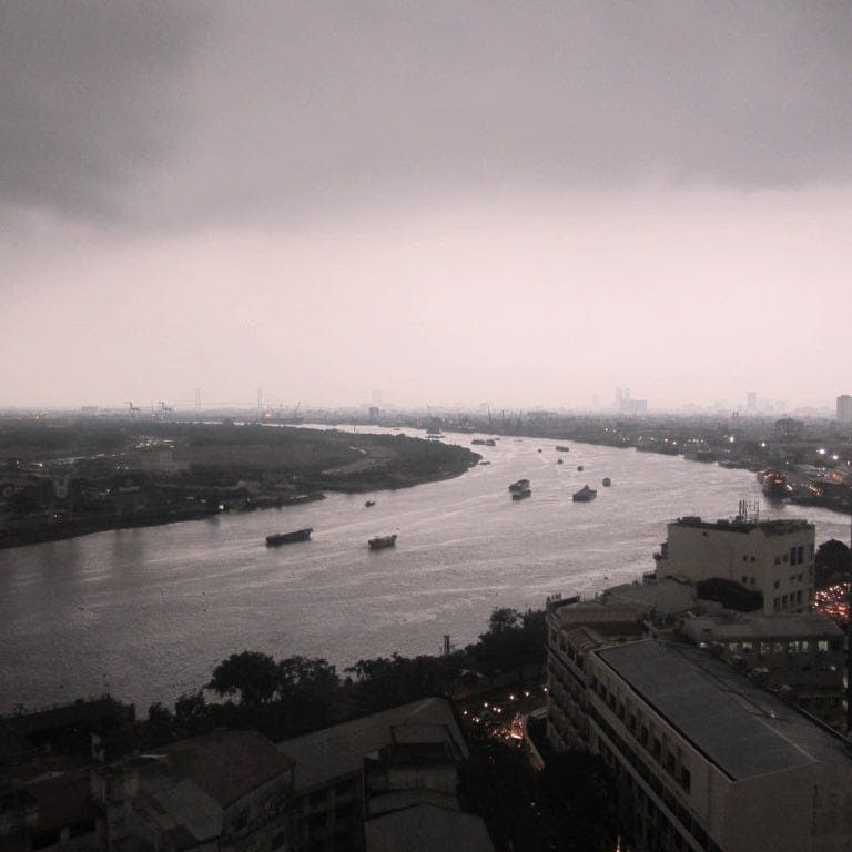
The Saigon River: looking east, downriver towards the docks, before a storm
[Back Top]
REFLECTIONS ON THE SAIGON RIVER
The first time I saw the Saigon River was as a teenager in 1999. My flight from Kuala Lumpur was on descent to Tan Son Nhat Airport. The plane banked left and I glimpsed, through the clouds, a rust-coloured trail weaving its way into a city of rust-coloured tin roofs. It looked, to me, like a large spillage of coffee: as if a god had left his or her teacup in the middle of Southeast Asia and absentmindedly knocked it over, causing rivulets of brown liquid to spread south, meandering towards the East Sea.


The Saigon River on a misty rainy season morning (photo by Samuel Mather Photography)
A river is the seed of any city that lies on its banks: without the river, the city would not exist. Most major cities with a long history are closely associated with their river: Rome has the Tiber, Paris the Seine, London the Thames, Cairo the Nile, Bangkok the Chao Phraya, and Saigon has the Saigon River. But, despite the city and the river sharing the same name, not much is made of the Saigon River.
When I first arrived in Saigon, it appeared that the city had turned its back on the river
In the late rainy season of 2005, I moved from London to Saigon. On my first night in the city, I went for a walk. I choose my route so that I would end up at the river. This, I thought, was bound to be where I’d find the heart of the city: both banks built-up and buzzing with life; the water shimmering with the reflection of all the lights of the city. But, when I got there, it felt as though Saigon had turned its back on the river. Only one side was built upon; the other was in darkness and mostly uninhabited. There were no bridges, no riverfront cafes, and most of the major buildings appeared to be facing away from the river.
VIDEO: The Saigon River [3.58]
View on YouTube
During French colonial times, things were very different. Back then, the majority of travellers arrived in Saigon by river: their first impressions of the city were from the deck of the vessel they were sailing on. French town planners, therefore, orchestrated the street layout of the city in such a way that the architectural showpieces of Saigon were visible from the water. Broad, tree-lined boulevards fanned out from the boat piers on the Saigon River, offering direct lines of sight to some of the most important and impressive buildings in the city, such as the Hotel de Ville and Notre Dame Cathedral. Although the basic street plan, laid out by the French, still exists in Saigon today, it’s lost its coherence, and there’s no longer any sense of theatre when viewed from the river, or even when approaching the city by boat. However, recent projects, like the Nguyen Hue pedestrian street and proposed redevelopment of the riverfront park, may bring the city and its river back together again.

A bit of a mess: seen from the river, Saigon’s waterfront is scruffy and incoherent
Cities are built on rivers for various strategic and practical reasons: trade, transportation, fresh water, as a natural barrier and line of defense and, let’s face it, waste disposal. However, as much as a river can be a lifeline for a city, it can also be a threat. The same waterway that opens up opportunities for trade with the outside world, also presents a way in for potential enemies, and exposes the city to attack. This is what happened to Saigon in 1859, when the French fired on the citadel from their ships on the Saigon River, thus ushering in nearly a century of foreign rule in Vietnam.


The river provides a route to trade with the outside world, but also a way in for potential attackers
Rivers, especially in tropical monsoon climates like Vietnam’s, also carry the danger of flooding. The Saigon River has always flooded: even today, heavy rains at high tide cause major flooding and disruption to the city every year. Indeed, the city’s name may originate from the Chinese-Vietnamese word for the kapok trees that used to line the flood dykes surrounding the city. Perhaps then, it shouldn’t come as a surprise that Saigon has turned its back on its river.

Each year, heavy rains & high tides cause the Saigon River to flood, sending the city’s streets into chaos
However, although the city may appear to ignore its main waterway, the Saigon River is still a constant presence. Whether you’re crossing the various watery tentacles – channels, creeks and canals – that branch off its main course and worm their way into the city’s neighbourhoods; or hearing the sound of fog horns in the dead of night, droning through the heavy rains and humid air; you’re always aware of the river; it’s always there, still flowing, still part of the city with which it shares its name, and to which it ultimately gave birth.

The Saigon River is a constant presence as you go about your daily life in the city
I spent the first 22 years of my life in London, which is, of course, another big city on the banks of a wide, meandering, muddy river. I loved the Thames: as a kid, I waded through its mud with my dad on Sunday mornings, scavenging for interesting bits and pieces; and, as a student, I ate my lunch and wrote my essays in cafes on the South Bank. But, I was always aware that the river’s heyday, when it was the largest port in the world, was over. Much of the Thames in London seemed more like a museum than a living, working river. The Saigon River, on the other hand, may well be entering its glory days.

Industrial revolution: the Saigon River may be entering its glory days as Vietnam’s economy prospers
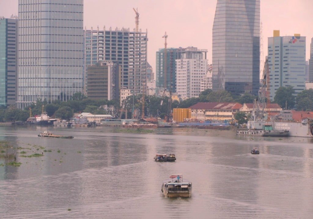
The Saigon River is emerging, along with the city as a whole, as a busy, commercial hub with huge and exciting potential, at least as far as shipping, industry and development is concerned. Saigon Port is now the 24th busiest container port in the world. There’s a constant flurry of boats of all sizes ploughing the viscous brown water: tankers, cruise ships, Mekong barges, river taxis, floating restaurants, industrial barges, private yachts, military vessels, and motor-canoes.


The Saigon docks are expanding fast, and river traffic has increased as trade continues to grow
Industrial zones, new ports and bridges are being constructed up and down river. The Thu Thiem area in District 2, across the water from downtown District 1 (where Sam and I used to enjoy respite from the city), is finally being developed. The Thu Thiem New Urban Area is one of many massive projects that will transform the relationship between the city and its river. It looks as though Saigon is beginning to turn and face its river once again, making the most of the natural space and cooler air that the river provides, and exploiting its commercial potential.

Bright future: developers are finally making the most of the natural space and cool air the river provides
Inevitably, all this comes at a huge environmental cost. The Saigon River is lined with over 50 industrial estates. From its source in Cambodia, the river takes a hard course: running through some of the most industrialized provinces in Vietnam, in and out of the country’s most populous city, then joining an even bigger river, the Dong Nai, before flowing into the East Sea just south of Vung Tau. Some researchers suggest that the river is actually in the process of dying, due to massive amounts of pollution dumped into it everyday. However, despite much of this pollution coming from the industries lining its banks, it is apparently domestic sewage – household waste disposed of directly into the river – that causes the majority of pollution.

Some researchers suggest that industry and household waste is killing the Saigon River
[Back Top]
VIEWING THE SAIGON RIVER
There are lots of great spots in the city from which to enjoy the Saigon River: from scruffy riverside cafes to rooftop bars, from local waterfront restaurants to boutique hotels. Below I’ve written about some of my favourite places to view Saigon’s major waterway, and plotted them all on my map:
MAP: Where to View the Saigon River:
Thu Thiem Tunnel Park: Above the entrance to the Thu Thiem Tunnel, on the east bank of the Saigon River, this little park has superb views across the river to the ever-growing skyline of downtown District 1. Head a hundred metres south of the main park and grab a plastic chair right on the river: order up a chilled coconut or an iced coffee and watch the sun set behind the skyscrapers. This is a popular spot for young Saigon couples, enjoying a romantic cuddle on the riverbank, watching the lights of the city reflected in the water. Get here between 4pm and 7pm. [MAP]

Sit back on a plastic chair and take in the views from the Thu Thiem Tunnel Park
Liberty Central Saigon Riverside Hotel: A great way to see the river, especially if you’ve just arrived in the city, is to book into a river-view hotel. Sure, you have to pay for the privilege, but it’s well worth it. Liberty Central Riverside is a relatively new hotel that sits on the busy riverfront road in downtown Saigon. Although Liberty is a chain, they’ve lifted their standards in recent years, and this location in particular is so stylish and sleek that it feels like a boutique accommodation. There’s a rooftop pool and bar with panoramic views of the Saigon River, and the floor to ceiling windows in the river-view rooms offer one of the best (and comparatively affordable) prospects of the river from any Saigon hotel room. Check rates & availability here. [MAP]
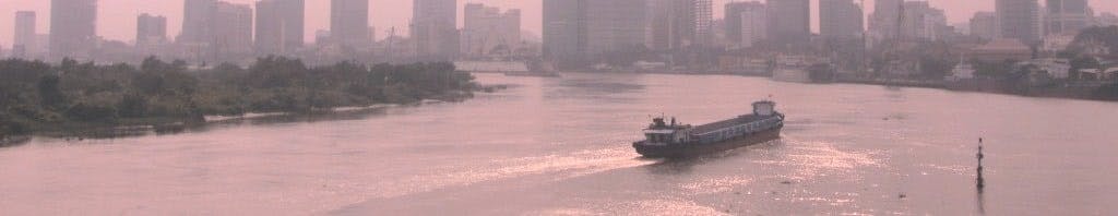
Thu Thiem Bridge: Opened in 2008, this bridge has quickly become a favourite photo-spot for locals, tourists and journalists looking to snap a good shot of the Saigon River, with the crenelated city skyline behind. The sweep and scale of the river is at its most obvious here, and large barges loaded with containers and construction material pass right underneath your feet. A popular hang-out in the evenings, I prefer to get here at dawn to watch Saigon emerge from the river mist. [MAP]

The Saigon River at dawn, seen from the Thu Thiem Bridge (photo by Samuel Mather Photography)
Thanh Da Island: Formed by a canal that was constructed to cut out a circuitous oxbow meander, Thanh Da Island offers perfect respite from the city, and lots of good locations to see the Saigon River. Binh Quoi Parks 1,2 and 3 all feature relaxed riverside restaurants and sprawling gardens. From Binh Quoi 2, at the northern tip of the island, there’s a little ferry across the river, which is a fun mini-trip. Countless small lanes lead off Binh Quoi Road to secluded spots on the riverbanks. Particularly interesting is the northeastern extreme of the island, where a new but unfinished suburban development has a riverfront road directly opposite the Saigon Port. It’s a great place to sit under a tree and watch the boats come and go. There are lots of good local cafes and restaurants along the riverside at the extreme southwest of the island, where the river and the canal meet. There’s also excellent riverfront accommodation on the island at Saigon Domain Residences. [MAP]

The small wooden ferry at the tip of Thanh Da Island is a fun little river trip
The Rooftop Bar at the Majestic: The Breeze Sky Bar, on the 4th floor of the Majestic Hotel, has great river views. Prices are high and quality is average, but you’re paying for the location rather than the drinks. Follow the stairs behind the main seating area as far up as they go. At the top, there’s a square patio with a couple of tables: here you’ll have the sweeping river views all to yourself. [MAP]
Lá Đỏ Goat Restaurant: This superb restaurant is hidden in a suburban residential neighbourhood, a way north of downtown. But the food and location make it a very worthwhile trip. Tables and chairs are laid out on a grassy bank under trees, just inches from the river. Large barges glide by and planes, coming in to land, pass overhead. The food is excellent – try the goat steamed in lemongrass, ginger and perilla leaf (dê hấp lá tía tô). [MAP]
The Deck: A swish bar tucked away among the swanky villas of District 2’s Thao Dien area, The Deck is great for a sunset cocktail and a bite to eat next to the Saigon River. The opposite bank is covered in tropical foliage. The river appears serene and healthy from here, even as large cargo boats chug past on their way to Saigon Port. [MAP]

Enjoy excellent food and drinks with a view of the Saigon River, at The Deck bar & restaurant
Thao Dien Riverside Hotels: Luxurious and relaxing, several hotels have sprung up in the well-to-do neighbourbood of Thao Dien, in District 2. Boutique, resort-style accommodation is well-suited to this enclave of wealth by the Saigon River. The location may seem far away from the frenetic energy of downtown Saigon (and that, of course, is the point), but the resorts’ river taxis mean that the centre of town is only ever 10 minutes away (the taxis themselves are a great way to see the river). Here are links to a few good riverside options in the area: Thao Dien Boutique Hotel | Villa Song | Riverside Apartments. [MAP]
The Rooftop Bar at The Grand: The new wing of this French colonial hotel may not boast much in the way of character, but the rooftop bar has excellent river views, especially when a storm’s approaching in the rainy season. Cocktails are good and there’s a sunset Happy Hour. [MAP]

Watching a storm approach over the Saigon River from the rooftop bar at The Grand Hotel
Sakê Restaurant: Another hidden restaurant on the banks of the Saigon River, Sakê is a large place with wooden furniture and good views over the water, in the shadow of Binh Loi Bridge. The owners are from northern Vietnam, and their standout dish is a northern speciality: grilled fish with turmeric and dill (chả cá Lã Vọng). [MAP]
Cột Cờ Flagpole: A pleasant new riverside promenade has been constructed at the confluence of the Ben Nghe Channel and the Saigon River. This is a great place for an evening stroll. The walkway is lined with benches and street lamps. At night, locals throw their fishing lines into the water, and young couples cuddle with a glass of milk tea. The Saigon docks can been seen to the right, while the city’s business district rises up behind the Cột Cờ Flagpole. [MAP]
RELATED CONTENT:
• The Saigon Midnight Motorbike Loop
• 13 Public Swimming Pools in Saigon
[Back Top]
Great article. Thanks. Are private boats allowed on the Saigon river? If so are there boat launches, docks, marinas or slips? I see Vinhomes Central park is building slips to dock boats. It seems too big just for those water taxis. I watch in anticipation as the river is developed for more to enjoy.
Hi Dan,
I’m sure that’s the idea for the future, but I don’t know for sure. I’ve seen one or two yachts that look like private ones, but I would imagine there’s a lot of bureaucracy and who-you-know (or just money) involved in getting a permit at the moment. But I’m just guessing.
Tom
Unlike the coast, there doesn’t appear to be many roads that run parallel to the river (at least within view of the river). Do you have any recommended route if someone wanted to travel the length of the river?
Hi David,
If you ride over the Thu Thiem Bridge or under the Thu Thiem Tunnel to District 2 and explore the roads near the river banks there you can find some excellent vantage points of the city. It’s in a constant state of flux over there though, because of all the construction.
Tom
Hi Tom, wondering if I can take a hydrofoil ride out of HCMC…
Yes, I’m pretty sure you can still take the boat from Saigon to Vung Tau. You can also hire boats to go out on the Saigon River for a couple of hours too.
Tom
Thank you Tom for your prompt reply. I will watch the video link when I have some spare time.
Fascinating stuff.
Best regards
John
Hi Tom, Good article I enjoyed it. Perhaps you can answer a question for me. I recently sailed into Ho Chi Minh City on a cruise liner up the Saigon River. We sailed passed a number of strange grey buildings approx. 6 stories high with what appears to be lots of bird noises emanating from them. Are they some sort of bird farms? Perhaps you can enlighten me.
John Russell
Hi John,
Yes, they are indeed bird farms, of a sort: the bird sounds – some recorded, some genuine – attract swifts or swallows to nest in the buildings. Then people harvest the nests (which are made of the birds’ saliva). The nests are then sold (at very high prices) to be used in various forms of cooking – the nests are said to have certain medical properties. Some ‘farmers’ get very rich from harvesting birds’ nest.
A recent episode of Bizarre Foods explores this in more detail: https://www.youtube.com/watch?v=yzuwKL1mPjI
Tom
Tom not Tim. Sorry mate. Bad eyesight strikes again. 😉
Hi Tim,
I have to congratulate you on the quality of your posts! The knowledge is one thing but the way you present it is fantastic.
Thank you for your great blog!
Thanks Stuart,
It’s always nice to hear from someone who’s enjoying my blog. I hope you continue to enjoy reading my new posts 🙂
Tom