
Last updated August 2020 | Words and photos by Vietnam Coracle | Read time 25 minutes | 101 comments
This post was last updated 5 years ago. Please check the comments section for possible updates, or read more on my Updates & Accuracy page.

Tom Divers is the founder and creator of Vietnam Coracle. In 2005 he moved from his native London to Vietnam, where he has been living, working and travelling ever since. He pays rent in Ho Chi Minh City but is more often on the road, riding his motorbike a quarter of a million kilometres across Vietnam to research guides to the farthest-flung corners of the nation. When he’s not in the saddle, you’ll find him on a beach with a margarita, in a tent on a mountainside or at a streetside noodle house: in other words, at the ‘office’. Read more about Tom: Q&A, About Page, Vietnam Tourism website.
Exploring a Bucolic Corner of Vietnam on Two Wheels
[Get the complete Offline Guide & Map Package for $15]
INTRODUCTION | GUIDE | MAP | RELATED POSTS
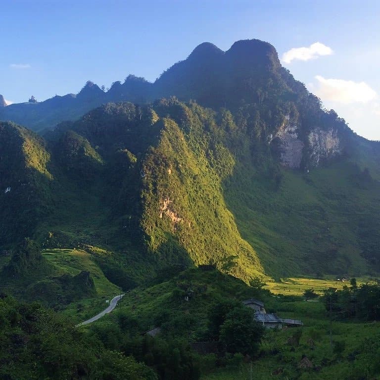
In my opinion, the three northeastern provinces of Cao Bang, Lang Son and Bac Kan currently offer the best on-road motorbiking opportunities anywhere in Vietnam. Why? Because all three northeastern provinces are utterly beautiful – characterized by limestone karsts, unbroken forests, misty mountains, blue rivers, farms, craft villages – and are crisscrossed by a growing network of increasingly good-quality paved back-roads and national highways; tourists are few, traffic is generally very light (with the exception of container trucks plying between remote Chinese border crossings), people are friendly, food is rustic and hearty, opportunities for getting off the beaten path are many, and there’s a real sense of adventure. This guide focuses on five different routes and loops within the three northeastern provinces. Each loop can be ridden separately or stitched together to form a ‘Great Northeast Loop’. Base yourself in Cao Bang, Lang Son, Bac Kan or Ba Be Lake and spend at least a few days exploring these routes by motorbike. The northeast is a great alternative to, or extension of, the Ha Giang Loop, which is now so popular it’s lost some of its magic.

In my opinion, the northeast currently offers the best on-road motorbiking opportunities in Vietnam
[Back Top]
THE NORTHEAST: 5 ROUTES & LOOPS
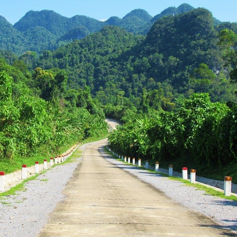
In this guide, I’ve mapped, described and illustrated five motorbike loops in the northeastern provinces of Cao Bang, Lang Son and Bac Kan. On the main map, I’ve plotted all five routes in different colours. However, each of the five routes also has its own separate map, which has much more detail, including road conditions, places to stay, see, eat, and drink. Any of these five routes can be mixed and matched and stitched together as and how you like, in order to create longer or shorter loops. All the northeast loops are highly scenic and great fun to ride: I’d recommend spending at least a few days riding them. Weather is best from March to October; it can get cold from November to February. There’s plenty of accommodation in the main northeastern cities and several good homestay areas scattered around (see each separate route map for specific suggestions). For bike rental, QT Motorbikes has a shop in Cao Bang. *[See Related Posts for links to my other motorbike guides in the region]

Click on an item below for more details:
CONTENTS:
- ROUTE 1: Ban Gioc Waterfall Loop (165/190km)
- ROUTE 2: Ba Be Lake Loop (315km)
- ROUTE 3: Mau Son Mountain↔Bac Son Valley Loop (190km)
- ROUTE 4: Bac Kan Back Roads Criss–Cross Loop (455km)
- ROUTE 5: China Border Crawl Loop (285km)
MAP:
Northeast by Motorbike: 5 Routes & Loops
Route 1: 165/190km | Route 2: 315km | Route 3: 190km | Route 4: 455km | Route 5: 285km
[Get the complete Offline Guide & Map Package for $15]
ROUTE 1: Ban Gioc Waterfall Loop
[Get the complete Offline Guide & Map Package for $15]
DETAILS:
- Route: Cao Bang→Ban Gioc Falls→Nguom Ngao Caves (optional return route)
- Distance: 165/190km
- Time: 1-2 days
- Scenery: limestone karsts, minority villages, majestic waterfalls, caves, remote borders
- Road Conditions: good surface, light traffic (some trucks), rough return route (optional)
ROUTE MAP: Ban Gioc Waterfall Loop (165/190km: blue/red route)
DESCRIPTION: Spreading east of Cao Bang City towards the Chinese border and the spectacular Ban Gioc Waterfall, this loop is the most popular of all the northeast routes. Manageable as a (reasonably long) return day-trip from Cao Bang, the Ban Gioc Waterfall Loop is full of wonderful scenery and good riding roads. However, because of ongoing construction and damaged roads caused by juggernauts plying remote routes to isolated Chinese borders, the lower (southerly) half of the Ban Gioc Loop (the red line) is currently in pretty bad repair, and shouldn’t be attempted unless you have a suitable bike or enough riding experience to tackle some tricky off-road, muddy sections. But, this needn’t concern other riders without a suitable bike or off-road experience, because the ride out to Ban Gioc Falls on the on-road route (the blue line) is so good that you won’t mind retracing your tracks back the same way. Or, even better, break the journey by staying a night at one of the atmospheric homestay areas on the route, such as Dam Thuy or Phia Thap, before returning to Cao Bang the next day.
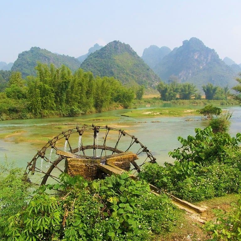
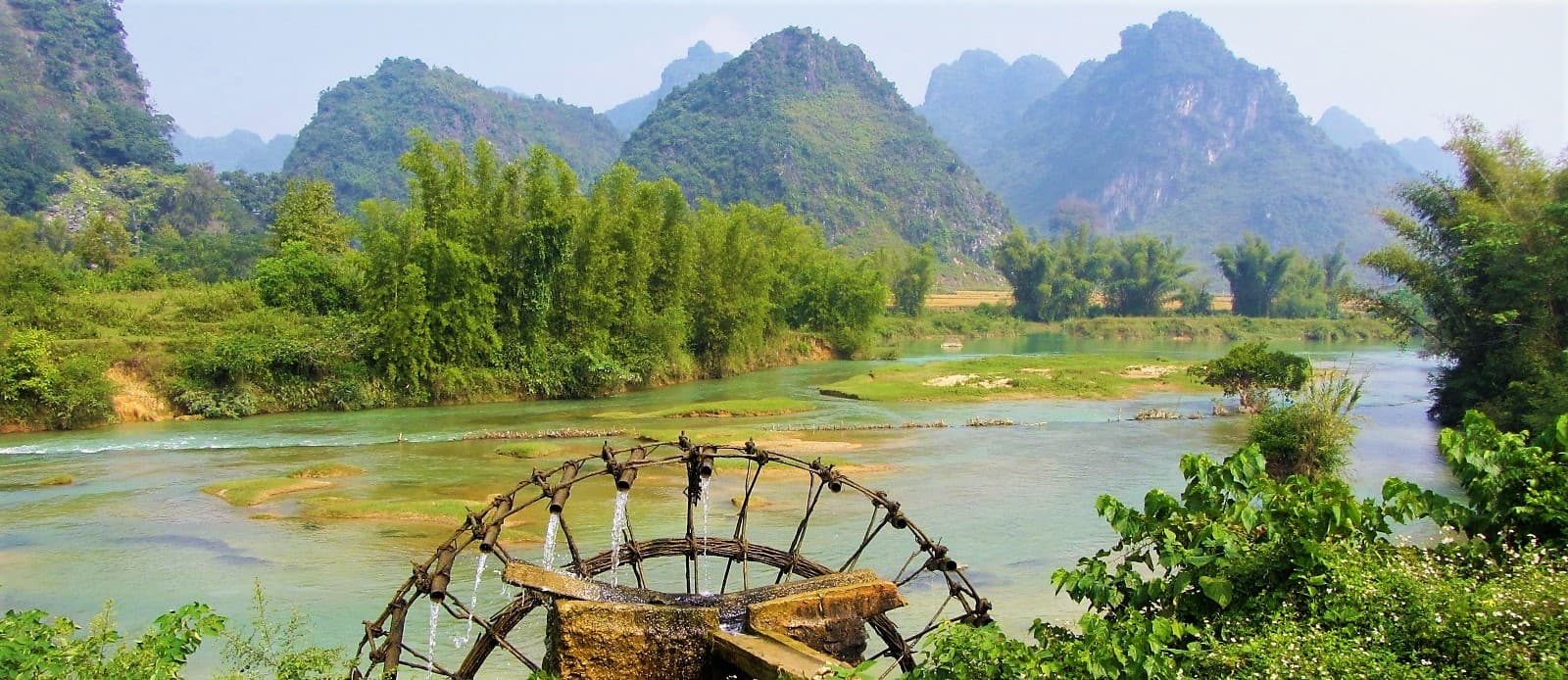
Heading east out of Cao Bang on road QL3, the route passes through lush valleys before ascending the formidable Ma Phuc Pass, which zig-zags up a to a junction where there are marvellous views down over the karst-studded valley. Onward to Quang Uyen, QL3 ploughs through picturesque farmland, where luminous rice paddies fill the flat spaces between limestone pinnacles. Several of the small hamlets specialize in crafts on one kind or another, most noticeably knives, which you’ll see displayed by the roadside. A homestay initiative here, at Phia Thap Village, is worth considering for a night with a local family in a wooden stilt home (try Mr Kim’s Homestay for hospitable hosts, wonderful food, and local knowledge). Quang Uyen, a decent sized town with food and refreshments and a few hotels, is the point at which the route veers north on road DT206, heralding the start of one of the most scenic and enjoyable rides anywhere in Vietnam. All the way between Quang Uyen and Ban Gioc Falls, via the dusty market town of Trung Khanh, the landscape is exceptionally beautiful. Characterized by jagged karst mountains – rising like Daliesque columns from rice paddies and corn fields – and jade-blue rivers flowing past bucolic scenes of wading buffalo, bamboo waterwheels, conical-hatted farmers, stone cottages and wooden cowsheds, the landscape around road DT206 is worthy of any great ink-and-wash Chinese landscape paintings. The road is smooth, easy to ride, and quiet. However, due to soaring trade with China, the peace can be spoiled somewhat by incongruous container trucks struggling up the hairpin bends and squeezing through the tight corners. (A new expressway is currently under construction to address this issue.) It’s also possible to cross the river to the north of DT206 and explore some dusty back-roads.
And then, of course, the star of the show: Ban Gioc Waterfall, one of Vietnam’s greatest natural wonders. It appears suddenly in the corner of your eye, then fills your entire vision. Crashing over multiple levels, filling a wide gap in the tropical foliage, the falls tumble down in white-crested layers, like an iced wedding cake. Framed by stands of giant bamboo and jungle-clad limestone karsts, Ban Gioc Waterfall is a genuinely breathtaking sight to behold. The falls lie right on the Chinese border, and there’s also an impressive cave system nearby, Nguom Ngao, with an illuminated trail through it. The Saigon-Ban Gioc Resort offers mid-range accommodation near the falls, and there’s excellent budget beds in the homestays at Dam Thuy Village (try May Linh and Minh Khanh homestays). Providing you have a suitable motorbike and riding experience, you can continue due south from Ban Gioc Falls on roads DT206/DT207 (the red line) along the Chinese border (at times, literally a stone’s throw away) towards Ha Lang (where there’s a guest house, if you should need it) and all the way back to Quang Uyen. This is the real boonies, and well worth the effort if you have the right wheels. If not, return to Cao Bang on the blue route, which, let’s face it, merits a second ride anyway. *[For much more about the waterfall see my Guide to Ban Gioc Falls].
IMAGES: Ban Gioc Waterfall Loop

The scenery on the Ban Gioc Loop is excellent: this is the Quay Son River through a limestone gorge

Around Ban Gioc Falls there are opportunities to get off the main route & explore some back roads

Looking down the valley from a hairpin bend on the Ma Phuc Pass, halfway between Cao Bang & Ban Gioc

Ban Gioc Waterfall, seen from above via a steep, treacherous path from the bottom of the falls

Situated right on the Chinese border, Ban Gioc Falls are a breathtaking sight, especially in the sunshine

Cao Bang City, a likable place on the banks of the Bang Giang River, is a perfect base to explore the northeast

Bamboo waterwheels grace the banks of the Quay Son River, just upstream from Ban Gioc Falls

On a good day, you could spend hours gazing & photographing Ban Gioc Falls from different perspectives

After the waterfall, Road DT206 follows the Chinese border, burrowing beneath a limestone karst

The alternative route (the red line) is scenic & off the beaten path, but road conditions can be rough

At times, the road on the red route deteriorates into a muddy track – difficult unless you have a suitable bike

Also close by Ban Gioc Falls, Nguom Ngao Cave is a haunting, mesmerizing sight
ROUTE 2: Ba Be Lake Loop
[Get the complete Offline Guide & Map Package for $15]
DETAILS:
- Route: Cao Bang→Ba Be Lake→Bac Kan on back roads & highways
- Distance: 315km
- Time: 2-3 days
- Scenery: jungles, lakes, mountains, river valleys, minority villages, homestays
- Road Conditions: paved highways & back roads, very mountainous, rough patches
ROUTE MAP: Ba Be Lake Loop (315km: blue route)
DESCRIPTION: A big, green, mountainous and highly scenic route southwest of Cao Bang, the Ba Be Lake Loop combines snaking national highways with narrow back-roads to create a hugely rewarding ride through jungles, rivers, lakes, and highlands. At 315km, this is a long loop which requires at least one night and two days to complete. However, you can choose to shorten the loop by taking either of the shortcuts (the red lines), effectively cutting the loop in half, and thus making it manageable as a one-day return trip from Cao Bang. But, to really get the most out of this loop, you should spend at least one night at a homestay on the shores of Ba Be Lake, not to mention taking a boat out on the placid water, visiting the caves and sights, and trekking in the countryside. The loop is generally fairly easy to follow and navigate, and road conditions are mostly very good. Two significant exceptions to this are: Road 254 around the eastern and southern shores of Ba Be Lake, and patches of the road leading south from Ba Be Lake to Ban Lanh, both of which have badly potholed sections and suffer from mud after heavy rains.
There are several places to stay on the loop, including guest houses in Cho Ra village, and mini-hotels in Bac Kan, the largest town on the route (try Green Hotel, a reliable budget option). However, the homestays on Ba Be Lake are by far the most atmospheric, good value, and rewarding accommodation in the area. Mostly run by local ethnic minority families, these homestays are usually concrete-and-brick or wood-and-thatch structures on stilts by the water’s edge, with easy access to the lake for swimming, kayaking, boat trips, and hiking in the national park. Thus, these homestays are the main hub for activities and sightseeing on the Ba Be Lake Loop. Mr Linh’s and Hoa Son homestays are good options, but there are dozens of others. *[For more information see my Guide to Ba Be Lake Homestays].
The most scenic sections of the loop are, well, they’re all fantastically scenic: Road QL34 west of Cao Bang to Tinh Tuc mining town is a serpentine ribbon of asphalt burrowing deep into the northern mountains; Road DT212 soars over cold, windy passes beneath the slopes of one of the highest mountains in the region, Pia Oac, before plunging due south past a high-end tea plantation, Kolia, and abandoned, century-old, French colonial-era villas to Cho Ra; all the roads to, from, and around Ba Be Lake are dripping with tropical foliage, rivers oozing out of the jungles from the high peaks of limestone mountains, the entire area heavy with an earthy dampness and a strong, mysterious presence as the landscapes wax and wane behind curtains of mist and rain; and Road QL3 back to Cao Bang is a long and dizzying ride through sublime scenery on a smooth surfaced national highway – one of the best riding roads in Vietnam. The riding is good, the scenery stunning, tourists are few, traffic is light: go now and make the most of it.

IMAGES: Ba Be Lake Loop

The twisting roads on the Ba Be Lake Loop lead deep into the green mountains of Bac Kan Province

Despite the difficult terrain, road conditions are generally pretty good on the Ba Be Lake Loop

Ba Be Lake is perfect for swimming, relaxing, kayaking, boat rides, and homestays with local families

Overnighting at a homestay on the edge of Ba Be Lake is a highlight of the loop: there’re many to choose from

Ba Ba Lake is an exceptionally scenic area: explore it on two wheels, on foot, or by boat

Road 254 around the lake is rough in places & several narrow suspension bridges lead across the water

Food in Bac Kan Province is good, especially the meals served up at the Ba Be Lake homestays

If the weather is cloudy & rainy, simply spend the day on your balcony watching life unfold on the lake

The Ba Be Lake Loop is particularly lush: around August-September the colour of the ripe rice is fantastic

Take a longboat ride on Ba Be Lake to visit some of the more remote corners of the national park

Road QL3 between Bac Kan & Cao Bang is a long & windy stretch of tarmac through marvellous mountains
ROUTE 3: Mau Son Mountain↔Bac Son Valley Loop
[Get the complete Offline Guide & Map Package for $15]
DETAILS:
- Route: Lang Son→Mau Son Mountain→Dong Dang border→Bac Son Valley
- Distance: 190km
- Time: 1-2 days
- Scenery: misty mountains, limestone karsts, rivers, minority villages, homestays
- Road Conditions: good, paved surfaces, some rough patches, light traffic
ROUTE MAP: Mau Son Mountain↔Bac Son Valley Loop (190km: blue & red route)
DESCRIPTION: Two scenic, mountainous loops connected by a smooth ride along a picturesque river valley, the Mau Son Mountain↔Bac Son Valley Loop is relatively short, fairly easy to navigate, and generally on good, well-made roads. However, there are a couple of rough road sections, which I’ve marked on my map with red lines or roadworks icons. Even these sections should be OK to ride in dry weather, but if wet they can become quite difficult. Start from Lang Son, a city that’s prospered on the back of increased trade with China. A small and friendly place with a pleasant buzz on its streets, Lang Son has lots of food, hotels, several sights and great markets selling all sorts of goods from across the border (see my map for suggestions of all the above).
Head east of the city on Road QL4B, leading through a pleasant valley, to the turnoff for DT237B, which climbs all the way to the summit of Mau Son. The road twists through jungle and pines high into the clouds, but is currently (2021) undergoing major renovations, so expect delays, dust and mud. At the top, a collection of restored and faux French colonial villas are all that’s left of an unlikely former hill station. It’s a bizarre and romantic sight. Several of the buildings offer accommodation, food, and drink, including the famous local liquor (ruọu), made special, supposedly, by the purity of the mountain spring water. If the weather is clear, the views are mind-blowing. But, Mau Son is almost permanently wrapped in cloud and mist, giving it an eerie, haunted, ethereal character. Either way, it’s well worth the journey. Just don’t come on a weekend or public holiday, when the crowds are insane; during the week, there’s hardly anyone here. The government intend to turn Mau Son into a tourist attraction on the grand, kitsch scale of Ba Na Hills, near Danang. So if that’s not your thing (it isn’t mine), visit now. From just below the summit it’s possible to loop back to Lang Son via a small paved mountain road heading north to Hai Yen, then connecting with Road DT235.
Pass back through Lang Son and start heading due west. There are two choices for this: take the smooth but busy Highway QL1A north towards Dong Dang then connect with QL1B heading due south and west; or take the more direct but potholed and muddy route on Road DT235C west of Lang Son before joining QL1B. Either way, it’s not long before you’re gliding through a pretty valley on QL1B, a fantastic riding road: smooth, clear, scenic and fast, brushing by a clear-flowing river, fragrant rice fields and limestone peaks. In season, the air here is scented with Star Anise, an aromatic spice that’s one of the ‘secret’ ingredients of phở. After Binh Gia village, the road climbs steadily, slicing through a cluster of forested limestone karsts, affording fabulous views down into the valley, where smoke rises from little hamlets of wood-and-tile houses. Bac Son lies at the bottom of the pass, a flat, rice-growing valley enclosed by a cradle of limestone karsts. The town itself is small and unassuming, but on its eastern periphery, where the rice fields are so brightly coloured it’s as if each blade has been charged with an electric current, there’s a homestay initiative, at Quynh Son hamlet. Staying in the wooden stilt houses here with a local ethnic minority family is a rewarding experience. Expect to pay around 200,000vnd for a night in a wooden house, including delicious home-cooked food.
However, before bedding down for the night in a homestay, ride the bucolic loop around Bac Son Valley, by combining roads QL1B with DT241 (note that the latter suffers from potholes). This 60km scenic ride wiggles between limestone pinnacles that break up oceans of rice paddy, bisected by a wide river. If you get hungry, look out for roadside vendors near Nga Hai selling tasty sides of crispy roast pork. Finally, save some energy for the steep climb through thick jungle to the Bac Son View Point, atop a limestone crag behind the town, for stunning views of the entire valley. After a night in a homestay, retrace your route back along the valley on QL1B to Lang Son to complete the double loop. However, it’s worth stopping in the intriguing border town of Dong Dang on the way for an hour, to soak up the strange atmosphere. Dong Dang train station is a fascinating building with an exhibition of Kim Jong-un’s visit in early 2019; Dong Dang Market has lots of Chinese goods; Dong Dang temple is a colourful, multi-storey pagoda; and the Friendship Border Gate is a busy trading post, choked with container trucks.
IMAGES: Mau Son Mountain↔Bac Son Valley Loop

Two connecting loops in Lang Son Province provide lush scenery, limestone karsts, misty mountains & homestays

Lang Son, a city thriving from cross-border trade with China, is a good place to base yourself for the loop

Road DT237B climbs steeply, clinging to the side of the valley, all the way up to Mau Son Peak

Mau Son, an abandoned former French colonial hill station, still has some crumbling villas in the mist

Bac Son valley is a stunning, almost martian, landscape dotted with limestone karsts

In Bac Son valley, the local homestays in Quynh Son village are a highlight of the loop

Brace yourself for a steep but short hike up to the Bac Son View Point, where there are stunning vistas

Hungry? Look out for delicious spit-roasted pork by the roadside – it’s a local speciality

The roads on the Mau Son Mountain↔Bac Son Valley Loop are mostly in pretty good condition

Take the time to stop by at Dong Dang, a border town with a fascinating train station

The landscape on the Mau Son Mountain↔Bac Son Valley Loop is often scented with star anise
ROUTE 4: Bac Kan Back Roads Criss–Cross Loop
[Get the complete Offline Guide & Map Package for $15]
DETAILS:
- Route: Cao Bang→Bac Kan→Lang Son via a criss-cross of rural back roads
- Distance: 455km
- Time: 2-3 days
- Scenery: deep forests, mountains, sparsely populated river valleys, minority villages
- Road Conditions: good surfaces, back roads & national highways, light traffic
ROUTE MAP: Bac Kan Back Roads Criss-Cross Loop (455km: blue route)
DESCRIPTION: A long, densely forested and sparsely populated route through landscape, and on roads, that most travellers don’t see, the Bac Kan Back Roads Criss-Cross Loop connects the three main northeastern cities (Cao Bang, Lang Son, and Bac Kan) via a series of overlapping back roads, offering a chance to get way off the beaten path while sticking to good, sealed roads. With the exception of Road QL4A between Cao Bang and Lang Son, which forms the eastern flank of this route, the Bac Kan Criss-Cross Loop utilizes several excellent, seldom used back roads that have all recently been resurfaced, providing easy riding and plugging you into isolated areas of thick jungles, rivers, and seemingly endless mountains. Start/end in either Cao Bang or Lang Son (it doesn’t matter which) and take your time eating up the miles on the ‘criss-cross’ of back-roads, meandering through one of the least populated provinces in Vietnam, past countryside rich in revolutionary history. This is the heart of the Việt Bắc region, historically a revolutionary stronghold, not least in the mid-twentieth century, when Ho Chi Minh and his entourage avoided detection from French authorities by taking cover in the tangle of steep valleys and forests. The riding is fabulous, the traffic is light, the scenery pristine, and the distances long but easily manageable in a couple of days, with an overnight stop in Bac Kan (try Green Hotel for a reliable budget option) or one of the local guest houses (nhà nghỉ) in the small villages on the back roads.
To the east of this loop is a long stretch on Highway QL4A. An ambitious, wide, smooth road, facilitating trade with China, QL4A is fun to ride as it curls over passes, along steep valleys, and through pretty farmland punctuated by limestone karsts. However, it’s marred by container trucks plying between Chinese border posts; the juggernauts often stalling as they crawl painfully up the passes. Indeed, a new expressway is under construction to address this issue, but won’t be completed for some time. Nonetheless, it’s still a decent and fast ride, linking two of the northeast’s major cities: Cao Bang and Lang Son. Stop in at Dong Dang, the main Chinese border town, for a look at its market and impressive train station. This is where Kim Jong-un entered Vietnam for his summit with President Trump in February 2019. The station features an exhibition of photographs commemorating the event. There’s also an interesting temple, and it’s worth riding up to the border to have a look at the imposing gates and hundreds of waiting freight vehicles.
Almost exactly in the middle of QL4A, the town of That Khe is the turnoff point for the ‘criss-cross’ of back roads. You can ride the ‘criss-cross’ in any direction, it really doesn’t matter. This is the point where the roads melt into the jungle: a network of connecting back roads twisting and turning through an incredibly lush, fecund, fertile landscape of rivers, jungles, mountains and karsts. All the back roads are now paved, although their condition deteriorates at certain points and, because the terrain is so mountainous, the roads are liable to suffer from landslides after heavy rain. But, in good weather, all riders on all bikes should be able to relax and enjoy these highly scenic, rural back roads. Gas stations are few, but each village has at least one. The same goes for food and accommodation: one or two local guest houses (nhà nghỉ) can be found in the villages marked with a red pin on my map, but it’s best to save your overnight stop for Bac Kan, where there are plenty of small hotels, including Green Hotel & Coffee. Settle into the ride and become pleasantly disorientated in the tropical foliage of Bac Kan Province.
IMAGES: Bac Kan Back Roads Criss-Cross Loop

Bac Kan is one of the least populated & least visited provinces in Vietnam, yet it is green, forested & beautiful

A series of good quality, narrow, paved back roads criss-cross through Bac Kan’s countryside

A buffalo bathes in a mountain stream: Bac Kan is riddled with rivers & valleys

Most of Bac Kan Province is densely forested: often, the narrow roads are the only sign of human activity

Although sparsely populated, most of the villages serve refreshments at mealtimes

Exploring Bac Kan Province on back roads takes you way off the beaten path, but still on good quality roads

Most of Bac Kan’s back roads are single-lane, meandering across the lush countryside

Traffic is very light, giving you plenty of opportunities to pull over, stop & admire the wide views

A daily train runs between Lang Son station & Hanoi, allowing you to take your motorbike on board

Stop by Dong Dang, on the Chinese border, to soak up the strange atmosphere of this old market town

Support My Work
Free | Independent | No Sponsored Content
“Hello, if you enjoy my website, please support it.
Thank you, Tom.”
ROUTE 5: China Border Crawl Loop
[Get the complete Offline Guide & Map Package for $15]
DETAILS:
- Route: Cao Bang→Bao Lac→Pac Bo Cave→Ma Phuc Pass via border back roads
- Distance: 285km
- Time: 2-3 days
- Scenery: mountains, incredible passes, remote borders, rivers, villages, historic sites
- Road Conditions: decent back roads, bad patches, susceptible to landslides, light traffic
ROUTE MAP: China Border Crawl Loop (285km: blue route)
DESCRIPTION: The most northerly of the five northeast routes, the China Border Crawl Loop is a mountainous circuit from Cao Bang, utilizing remote and extraordinarily steep and twisted roads, often clinging to an isolated section of the Chinese border. Although the China Border Crawl Loop is long and winding, it is possible to ride the entire loop in a long day on the road, providing you leave early and have good weather. However, it’s more enjoyable to take your time, breaking the journey at one of the mini-hotels in Bao Lac for a night. Alternatively, you can cut the loop in half by taking either of the two shortcuts (the red lines) back to Cao Bang. The scenery is fantastic, the roads are astonishing, and the sense of adventure is real and raw.
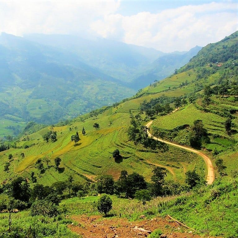
Heading west from Cao Bang, Road QL34 is a wonderfully knotted ribbon of tarmac, corkscrewing up green mountains of terraced rice fields, soaring over cold, high passes, and plummeting into tight valleys all the way to Bao Lac. A small town at the confluence of several rivers, Bao Lac is a good place to grab refreshments or a bed for a night (I’ve marked several hotels on my map), before riding due east on what is one of the most astonishing roads in the country. Following the Gam River east of Bao Lac, this as yet unnamed road is currently the talk of many riders in Vietnam. Hugging the Chinese border for much of its length, the road passes through some extremely remote landscapes. As if the fabulous scenery weren’t enough, the road itself is quite a sight. The narrow asphalt lane is full of contortions and knots; constantly switching back on itself as it negotiates the difficult terrain. To look at it on the map it’s as if the road were alive: an agitated dragon, shifting violently from left to right, trying to shrug an assailant off its back. One pass, in particular, is breathtaking: Ascending what is essentially a vertical wall of rock, the road passes 14 (by my count) consecutive switchbacks. I’ve taken to calling this the ‘Dragon’s Stairway’ or ‘Roller Coaster Pass’ (I’ve never been able to decide between the two). However, Google Maps has recently named it đèo Mẻ Pia.
At times gravelly and potholed, this border road runs all the way east through Can Yen village until it hits the Ho Chi Minh Road (DT208), just south of Pac Bo Cave. Definitely worth the short detour, Pac Bo is a significant historical site in a highly scenic location. This is where Uncle Ho re-entered Vietnam in 1941, after 30 years of absence, to begin his struggle for an independent nation. (See my Guide to Pac Bo Cave for details.) To continue on the loop, turn east on DT210, a seldom used back road climbing sharply up limestone cliffs and shadowing the Chinese border to Tra Linh. Cutting a huge white gash in the landscape, the narrow road twists through a forest of chalky limestone karsts, passing through remote villages that appear to be stuck in time. Homes are made of packed mud and straw with baked-tile roofs; oxen, buffalo, and horses transport crops, farm equipment, and people from field to village; stone walls divide fields of rice, corn, and soy beans; hay is stacked by children into 20-foot-high pylons, echoing the shape of the limestone hills; and a rocky creek ekes through the valley, providing animals and farmers with a bath after a hard day’s work on the land. At Tra Linh, turn due south onto Road DT205 (perhaps stopping at Thang Hen Lake on the way) and connect up with QL3 at the Ma Phuc Pass, heading all the way back to Cao Bang.
IMAGES: China Border Crawl Loop

Heading west of Cao Bang to Bao Lac, Road QL34 passes Tinh Tuc mining village & vast karst landscapes

Along the road to Bao Lac rice terraces are carved into steep hillsides above the gushing Gam River

Bao Lac sits at the confluence of several rivers, a pleasant location for a remote little town

Bao Lac market is a good place to fill up as there are few dining options on the rest of the loop

The Dragon’s Staircase is an extraordinary pass: this photo doesn’t do it justice – but, trust me, it’s spectacular

Make time to stop at Pac Bo Cave, an important historical site in a highly scenic location, abutting China

The northernmost extent of the Ho Chi Minh Road gives you the option of cutting this loop in half

East of Pac Bo Cave, Road DT210 climbs into the karst mountains, shadowing the Chinese border

Tra Linh is a remote outpost near a border crossing into China: it will probably grow in the coming years

Along Road QL3 back to Cao Bang City, there’s most gorgeous scenery on the home stretch
Disclosure: I never receive payment for anything I write: my content is always free and independent. I’ve written this guide because I want to: I like these routes and I want my readers to know about them. For more details, see my Disclosure & Disclaimer statements here
[Back Top]


I just randomly found your page through Google. As a Vietnamese person, I feel a bit embarrassed reading such a detailed travel guide about my own country written by a foreign blogger. You dive deeper than most travel bloggers out there, especially in this era of short-form content. Great job, Tom — you did an amazing job. Thank you for your love for my country.
Hi Nick,
Thank you for your kind words about my site, I appreciate it. I am looking forward to exploring more and more of Vietnam and hopefully writing about it here.
Best,
Tom
Hello Tom,
First of all absolutely hats off to your great work compiling these routes, we all highly appreciate your work. I’m planning on spending 10 days riding in the extreme North and Northeast area of Vietnam and want to cover a few of the routes you mapped out. My plan is to start in Ha Giang, doing the loop clockwise until Meo Vac, and continuing to the China Border Crawl via Bao Lac. I want to combine the China Border Crawl – from the outskirts of Cao Bang – with the Ban Gioc loop and get back to Cao Bang after. If I still have the energy and time, I’m considering also doing the Ba Be Lake Loop with a short cut just to conclude my adventure in Cao Bang and leave from there to Hanoi. My question is, do you think this itinerary is realistic (without being overly rushed) for my 10 days? If you advise to shorten the trip, which part would you suggest skipping? Thanks so much for your help!
Best, Marcell
Hi Marcell,
Yes, your itinerary is possible in 10 days, but you will be on the road for much of the day, every day. This isn’t necessarily a bad thing as on a trip like this the ‘journey is the goal’. So as long as you expect to be riding every day and stopping along the way for views, meals, sites, etc, then 10 days should be OK.
However, if you prefer to take it slower and be more static in your destinations, then just leave out the Ba Be Loop at the end if you don’t have time to do it.
In general, travelling in Vietnam is better when you remain flexible and not on a tight, rigid schedule.
Best,
Tom
Hey all, just completed two loops from this page. We based ourselves out of Cao Bang (Pia homestay was great and their bikes were new). We postponed coming here by about a week due to severe floodings in the area. The city is back on track and the ride had some landfalls here and there but it was manageable. We did two days on the route to Ban Gioc waterfalls going clockwise, stayed at Lan’s homestay which was comfortable and had good food. Roads here were excellently paved and traffic was minimal although we did see some organized groups on easyriders.
We then headed to Ba Be lake driving clockwise as well, using the red shortcut to get to our accomodation (Legend Hotel was solid but food was expensive). We took the boat trip with our scooters on board which was a cool way to cover some distance. The ride back was stunning, I highly recommend not retracing your steps on this one. Thank you Tom for charting out such nice rides and making it all so accessible!
Hi Avi,
Thank you for the trip report. Sounds like you had a great ride!
Best,
Tom
What a goldmine your website is—really well done!
Could you give us some advice? (I know everyone is different and experiences things differently, but we’d love to hear your thoughts.)
We have 6–7 days and we’re hesitating between riding part of the Ha Giang Loop and continuing on to Cao Bang, or spending several days exploring different northern loops starting from Cao Bang.
We hesitate because of the stories about crowds on the Ha Giang Loop. But if we skip it, we worry we might miss some amazing scenery—it’s popular for a reason.
What would you recommend for a couple (I’m an experienced motorbike rider and my girlfriend will ride with me) who are looking for great views, nature, culture, and a relaxed pace?
Hi Jeroen,
Thanks for your message.
Yes, it is a difficult decision. Personally, I would chose to explore the Northeast Loops (including many other roads that aren’t covered on this page) rather than the Ha Giang Loop.
However, it really does depend on your priorities. The landscape and roads in Ha Giang are superb, but the thrill is lessened by the sheer number of people riding there these days – it really can distract you from the riding and the scenery. Meanwhile, the Northeast is very beautiful indeed – maybe not as dramatic and ‘strange’ landscape as Ha Giang, but still sensational for riding and scenery. Furthermore, tourism in most parts of the Northeast is still very light, so you have the thrill of a real adventure.
Whatever you decide to do, I hope you have a great trip.
Best,
Tom
Thanks, Tom, for your comment! We decided to do the first part of the Ha Giang Loop and then continue on to Cao Bang to explore some routes in that area. If the first section of the loop feels too busy, we’ll just make it a long riding day and head toward Cao Bang as soon as possible. Just bought your guides, we’ll be well prepared! 🙂
Hi Jeroen,
Well, that sounds like a good plan! And thank you for buying the guides, I hope they are useful and that you both have a great time.
Best,
Tom
Hi Tom,
Just wanted to let you know what we chose and how our trip went.
We started in Ha Giang and rode the loop clockwise to Meo Vac. The roads were really good, and it wasn’t busy at all. Because of the bad weather in Vietnam (which we didn’t experience ourselves), many people seemed to cancel their trips. We also saw very few easy rider groups.
After Meo Vac we took the QL4C to Bao Lac. The bamboo ferry raft route looked difficult, especially after months of rain. From Meo Vac we took the China Border Crawl route to Cao Bang (beautiful route!!) From Meo Vac onwards we saw almost no tourists.
From Cao Bang we also rode the Ban Gioc Waterfall loop — absolutely beautiful.
In the end, it was a great choice to combine the famous Ha Giang Loop with quieter, less touristy areas. If you leave early (around 07:00–08:00), you stay ahead of most tourists and groups. It was an amazing trip with great views, and we had no issues on the way. The police were friendly too, as long as you have the correct international driving permit. A couple from Spain found out that their country issues the wrong type, and they got a big fine (about €100 because they rode with limited cc bikes).
The routes on this website helped us a lot! The offline GPS maps and the booklet were super useful.
If we go back to Vietnam, we’d definitely ride for more days.
Hi Jeroen,
Thanks, it’s great to hear you enjoyed your road trip in northern Vietnam and that the Ha Giang Loop wasn’t too busy. I hope you get a chance to return some time and ride more routes.
Best,
Tom
Hi Tom
I’m wondering whether this journey is doable without a motorbike – I don’t drive them, and a scooter is clearly out of question.
Cheers
and
Hi And,
You could go to some of the places on the loops on public transportation, such as Ban Gioc Waterfall, Pac Bo Cave and Ba Be Lake. Of you could hire a car and driver from your accommodation to take you on these loops (usually around $100 pr day). Or you could cycle or a scooter is fine too – the bike I use is technically a scooter.
Best,
Tom
ok, thanks! From reading your, and others’ report, I figured something more than a scooter was required. Good to know this is not the case. I can definitely rent a 125cc semi-automatic like those qtmotorbike is advertising in their website. Apologies if the question has been asked already, but, I was wondering whether my driving licence (from EU) is sufficient to drive a scooter in Vietnam.
thanks again
and
Hi And,
For licenses, it depends on the kind of license you have – there are different conventions under which the licenses are issued. It’s best to ask the rental companies for more advice on licenses.
Best,
Tom
Hi Tom, I appreciate all this invaluable information about routes, sites, and places to eat or rest.
My wife and I are planning to leave Ha Giang and tour the north, including the road you call Dragon Road and go down to Cao Bang, then go to Ban Gioc and go down to Ba Be Lake and Hanoi.
My question is whether six days will be enough. We’re experienced motorcycle travelers and we’ll do it on a CB 500 X.
Do you think it’s possible?
I appreciate the response and the time spent sharing the information.
Best regards.
Toni Muñoz
P.D( sorry is google translator)
Hi Toni,
If you are planning to ride the Ha Giang Loop and then the Northeast Loops in just 6 days, then it is doable but you will be spending almost all day, every day on the road.
I would recommend spending at least 10 days instead, because that will give you enough time to ride all the routes at a more relaxed pace and be able to enjoy the riding and the scenery more.
Best,
Tom
I rode the ban gioc waterfall, China border crawl and ba be lake routes in August 2025.
Ban gioc was fantastic riding, as others have mentioned the red route is in great shape. The waterfall itself was not too pretty due to too much rain but the surrounding area was beautiful and pagoda viewpoint is great. Also the cave nearby is worth the visit and i enjoyed a lot.
The China border crawl, when you leave bao lac, has some of the most fantastic views i have seen. The riding is difficult at some points on the return, at one point my bike was completely stuck in mud. Would be aware of this after heavy rainfall. Still really enjoyed it.
Ba be is a fantastic loop, and the riding into ba be (i went clockwise) is one of the most beautiful and breathtaking roads. The road to connect to this nearly paved road is rough – i wonder if you can begin the paved road earlier. On the way back i encountered a landslide that blocked my route – so i had to take both shortcuts outlined in the map so get back. It was worth it because the riding on the last half of the loop is nothing short of phenomenal
Hi Spence,
Thank you for the trip report and updates. I love this corner of Vietnam and I’m happy to hear that you enjoyed riding there.
Best,
Tom
Did Ban Gioc Loop in November 2024.
The southern part of the loop along DT206/207 is now beautiful road and was in great shape.
Hi Parry,
Thank you, that’s great to hear! I look forward to riding it myself again sometime soon.
Best,
Tom
Do you think going from Cao Bang city to Ban Gioc falls heading north on DT 205 and then east on DT 211 is doable? Would like to see Nui Thung and Phong Nam valley in the way to Ban Gioc. Thanks in advance.
Hi Rick,
I think that should be OK, yes.
Best,
Tom
Hi Tom – we’ll be arriving in Hanoi for a fortnight in March and intend to ride Ha Giang and the North East independently on hired bikes? From your experience, is there a best direction to ride, clockwise or anticlockwise? Do the big tour groups all go the same way?
Thanks
Jim
Hi Jim,
No, not really. Just take into account that the Ha Giang Loop is very popular these days – you are likely to encounter hundreds of riders/groups on the standard loop each day, whereas the Northeast Loops are still very rarely visited by foreign riders/travellers.
They are both excellent riding destinations with incredible scenery: the main difference is that one of them (Ha Giang) is hugely popular, while the other (the Northeast) is not.
Best,
Tom
Hey Tom,
Aamzing Info.
As of October 2024 the suspension bridge near Ba Be Lake is out of operation and you need to take a raft to get across. Totally doable but the rough section you highlighted is about 10x rougher now.
Otherwise great road conditions, very light traffic.
Cheers!
Hi Sam,
Thank you for the update – very useful to know. Sounds fun! And I’m sure it won’t be too long before they fix the bridge and reopen it again.
Best,
Tom
Dear Tom.
Going tomorrow morning from Ba-Be to Cao Bang. Which way is better? QL34/QL3?
Thanks !
Hi,
They are both good, scenic roads. Enjoy!
Tom
Hey dear Tom,
First and foremost, we’d (my partner and I) like to thank you deeply and tell you how much your website is something we rely heavily on during our 1 month trip here in Vietnam. Just finished the Sapa-Sin ho loop, and it was out of this world.
We are now planning our next trip around Cao Bang, eventually going down to Halong bay and back to Cao B area. We wanted to ask you, what would be the best trip you suggest if we want to have a couple of days we want to spend around Cao Bang are and trails and we want to put together a mix of the loops? We have a good motorbike and we’re quite experienced.
We think of putting together a mix of the eastern side of the loops, going to Halong Bay, and going back from the South-Western side of the loops. Any suggestions?
Thanks!!!
Hi Yotam,
Thank you for your kind words.
Yes, a combination of the loops as you suggest is a good idea. If you have a good bike then you should be able to have fun exploring lots of roads in that region. The least-travelled on the 5 Northeast Loops are Route 4 (Bac Kan Criss-Cross) and Route 5 (China Border Crawl).
You can also consider looking at the Binh Lieu Loop and Section 1 of the Trans-Northern Belt Road if you’re going to extend down to Ha Long.
Best,
Tom
Hi Tom,
Thanks for this guide. Priceless!
Just completed the Cao bang loop, combining some of those loops together. Confirming that the roads are pretty good. The Dragon Staircase pass is still in construction but half of the pass is nearly complete. As long as it doesn’t rain, it is okay. I guess it will be complete in the next months. The highlight of this loop was the Chinese border road between Pac bo and Bao Lac. Almost as nice as what we can see on the Ha Giang loop but without the Easy riders / backpackers hordes.
I would like to mention a new motorbike shop in Cao Bang, Cao Bang Green Riders, which is amazing. Never got such good bike, accessories and level services in my life. Really recommend Lin and her team.
Best,
Hi Arnaud,
Thank you for these important and useful updates on road conditions. I’m glad you enjoyed these routes.
Best,
Tom
Hi Tom,
Thank you very much for your detailed article!
I have one question: Do you need some kind of official permission to travel near the Chinese border? Especially for Route 1 and 5. If so, where can I get it in cao bang?
Thanks in advance!
Hi Lennart,
You should be OK to ride those routes without a permit, just don’t go off the roads near the border or do anything ‘suspicious’ around there. If you do encounter any authorities, ask if you’re OK to continue on the road.
Best,
Tom
I rode the red path from Ban Gioc to Cao Bang. I asked two separate locals beforehand, they both said it’s OK to ride. They were right. I haven’t encountered any rough terrain, only paved roads of the same quality as the blue, northern section.
Would it be possible to update the article, or at least put “*see comments for changes”?
Hi Gabor,
Thank you for the update – that’s great to hear.
Yes, there’s already a notice at the top of this guide (and every guide that is more than 3 years old) directing readers to refer to comments for useful updates. I can’t write updates in the guide directly unless/until I experience them first hand.
Best,
Tom
Hi Tom,
I am planning a ca. 2 week motorbike tour out of Hanoi in the second half of October and am trying to decide between doing the Northwest, a variation of your Limestoon loop and up to Sapa and the Northwest regions, or instead of that traveling to Ha Giang and doing some of these suggested routes in the Northest.
Could you give a suggestion? I have been to Hanoi once and spent a few days riding around Tam Coc and loved it.
Hi Dan,
Personally, I would suggest the latter option: go Ha Giang and ride the northeast. October should be an excellent time of year to ride that region. The scenery and roads are extraordinary. If you really like Ha Giang, you could easily spend all your time exploring the roads there; if you find Ha Giang too busy with other riders, you can simply ride further east to explore the routes on the page above, which are less visited by riders.
You can find lots of suggested routes and itineraries for Ha Giang and the Northeast on my site. But please bear in mind that road conditions change all the time, but generally they get better, not worse 🙂
Best,
Tom
Hi Tom!
Great content here! Thanks for all the info!
I did the Ha Giang Loop based on one of your posts and loved it! I am doing another loop on October and I am not able to decide which one to do. I want it to be at least 3 nights or 4 nights. Which one would you suggest me to do?
Thanks!!
Hi,
I think combining the China Border Crawl and the Ban Gioc Loop would be a good option for a few days and nights.
Best,
Tom
Updates:
Route 5 Chinese Border Crawl Loop: We did the northern part of the loop, coming from Ha Giang to Cao Bang. No bad road conditions anymore, just fantastic scenery! Also Dragon Staircase has a free view point, around 1km hiking from the top of the staircase you get a perfect view of all switchbacks. Ask locals at the top for directions and follow red arrows.
Route 1 Ban Gioc Waterfall Loop: The Red Line is now a paved street, perfect road conditions so can be changed to blue.
Hi Kristina,
Thank you so much for these valuable updates – they are very useful to me and all riders considering riding these routes.
Best,
Tom
Hello, Tom. I’m contemplating a late April – early May ride of the Bac Kan backroads criss-cross loop. You mention that one can start in either Lang Son or Cao Bang. I would want to rent a good, dependable motorbike for the trip. Is there/are there particular rental shop(s) in either of the two towns that you can recommend? Thanks in advance!
Hi Rick,
QT Motorbikes might still have a rental shop in Cao Bang – check their website and contact them to ask. Also, it’s likely that some of the good rental companies with outlets in Hanoi that I mention on this page will be able to arrange for you to pick up your motorbike in Lang Son or Cao Bang (at an extra cost, of course).
Best,
Tom
Thanks a million!
Hi Tom, Over the last few years we have had some great tips from your website. We will be flying to Hanoi and catching the limobus to Ba Be lake, then bus to Cao Bang. At Cao Bang we hope to rent an XR150 , ride to Pac Bo for our first night, then to Ban Gioc for a few days before staying at Phia Thap. We will visit Hen Thang Lake and the mountain with the hole in the middle, before returning to Cao Bang. We are preparing what clothes to bring and studying the websites for weather. Am i correct in assuming that Ma Phuc pass would be the highest area we pass thru at 700m ASL or are other parts of the road are more ASL. I will also be making a detailed report so i can post here to help others.
Thanks, David
Hi David,
Thanks for your message – it’s great to hear you’ve used to site in the past and that you’re coming back to Vietnam soon.
I can’t really advise about weather conditions, temperatures and what clothes to pack without knowing which month of the year you’re intending to travel(?) You can also take a look at my Weather Guide for some related information about that.
As for altitude, after Be Ba you’re essentially in the highlands for the rest of the trip and everywhere has the potential for chilly conditions (especially with the added wind chill factor on bikes) between October/November and March/April.
Best,
Tom