
Last updated August 2019 | Words and photos by Vietnam Coracle | 84 comments
This post was last updated 6 years ago. Please check the comments section for possible updates, or read more on my Updates & Accuracy page.
INTRODUCTION | GUIDE | MAP | RELATED POSTS
The extreme northwest of Vietnam – the big mountainous bulge west of Highway QL12, around the Black River basin – is probably the most remote region of the entire country. Straddling the border of Dien Bien and Lai Chau provinces, it’s certainly one of the least-travelled areas in Vietnam. The extreme northwest abuts both China and Laos, thus this route travels through extensive borderlands, which are often very sensitive. Indeed, this region is perilously close to the infamous Golden Triangle. As such, local police and government officials may hinder your progress. However, old roads have recently been upgraded, and new ones have been blown through the mountains, creating an extremely mountains, off-the-beaten-track, and circuitous route between Lao Cai and Dien Bien Phu. The roads lead further, higher, and deeper into the northwest mountains than ever before, threading between peaks pushing 10,000ft, which are the southeastern-most extent of the same geological collision that formed the Himalayas. It’s also possible to turn this route into a loop.

The Extreme Northwest is probably the most remote, least travelled & mountainous region in Vietnam
[Back Top]
GUIDE: THE EXTREME NORTHWEST
ROAD TRIP DETAILS:
- Total Distance: 800km/400km/310km (one-way)
- Duration: 2-7 days
- Route: three remote & mountainous routes between Lao Cai & Dien Bien Phu [MAP]
- Road Conditions: paved back-roads, new highways, light traffic, regular landslides
- Scenery: mountains, rivers, rice terraces, minority villages, remote borderlands
Selected Resources What’s this?
CONTENTS:

The Extreme Northwest is characterized by forested highlands rising above the Black River basin
*IMPORTANT: Parts of this route travel through sensitive areas: please read the following paragraphs carefully before setting out on this road trip.
The main route in this guide is all about exploring remote roads and regions: it’s by no means the most direct route between Lao Cai and Dien Bien Phu, and sometimes it requires back-tracking. But the rewards are big scenery and virtually no other travellers. The total distance between Lao Cai and Dien Bien Phu via the main route (the blue line on my map) is 800-900km. However, you can also turn this into a loop by returning via road QL6 and Sin Ho (the green line on my map: 400km), or the most direct route via QL12 and QL4D (the red line on my map: 310km). Using any of these routes, the one-way or return journey between Lao Cai and Dien Bien Phu can take anything between 2-7 days, depending on road conditions and weather. Despite its remoteness, the roads are generally in reasonable condition and there’s accommodation (usually in the form of local guest houses, called nhà nghỉ) at all of the towns and villages marked with a red pin on my map. However, as the roads are so mountainous, they are highly susceptible to landslides, especially after heavy rains, which can render them impassable for hours or sometimes days. In my experience, weather is best from March-May and September-October.
You need a lot of time, patience and flexibility for this route, because if the landslides don’t stop you at some point, the local authorities will. The border regions are very sensitive to the Vietnamese government and army. In particular, if you ride the roads between Muong Te, Muong Nhe and A Pa Chai (marked with a black line on my map), you should ask permission at the local government/police offices first; or head out and hope for the best, but you do so at your own risk. If stopped you will most likely not suffer anything worse than a fine, but there’s always the possibility of something more serious, such as your bike being impounded or even visa issues. In general, I found the authorities on this route to be polite and accommodating. But remember, you are a guest in another country.

The Extreme Northwest is more accessible than ever thanks to new roads, but remains a sensitive region
About this Map & Guide:
Below is a detailed, annotated route map followed by a short image gallery illustrating the kind of landscape and scenes you can expect to find on this road trip. On the map, I’ve outlined 3 main routes between Lao Cai and Dien Bien Phu. The blue route is the real Extreme Northwest: this is the longest, most remote, least travelled, and highest of all the routes. The green route is slightly shorter, with equally spectacular landscape and unpredictable road conditions. The red route is the easiest, most direct, and most travelled (but still highly scenic and remote). In general, the idea is to take one route out and another route back, thus creating a full Extreme Northwest Loop. On my map, I’ve started the route at the train station in Lao Cai, because this is where many travellers begin their road trips in northern Vietnam, having shipped their bikes as freight on the overnight train from Hanoi. However, another convenient starting point is Sapa, since it’s such a popular destination and there are many places to rent motorbikes. (Note that the route from Lao Cai to Sapa is covered in my Y Ty Loop Guide and the route from Sapa to Sin Ho is covered in my Sin Ho Loop Guide.)
As mentioned before, bear in mind that this is an extremely rugged, remote, sparsely populated, and politically sensitive part of the country, so take your time and take it easy. Roads can be dangerous, not because of traffic, but because of landslides, potholes, and inclement weather. Much of the Black River valley has been flooded for hydroelectricity projects, and this has shifted road routes away from their original course along the river banks: in some cases, Google has yet to update its maps, so there are some discrepancies between the roads as they appear on the map and their actual route. However, the general route is still the same, just several kilometres further away from the river banks, and it shouldn’t be too difficult to navigate. There’s at least one local guest house (nhà nghỉ in Vietnamese) or hotel in each of the places marked with a red pin on my map. Gas stations aren’t frequent, but can been found in most of the villages and towns on this route.

*WARNING: Police and army personnel patrol much of the border territory on this route. When it comes to the authorities, the biggest challenge is the road near the Chinese border, which links Muong Te with Muong Nhe, with a side route to A Pa Chai, the point where Vietnam, Laos, and China meet. In fact, parts of this road are so sensitive that it doesn’t appear on most maps (I’ve tried my best to draw it on my map in black). If you choose to take this road, it’s highly advisable to seek permission in Muong Te or Muong Nhe before attempting to do so.
ROUTE MAP:
The Extreme Northwest: Lai Cao→Sapa→Dien Bien Phu | 3 Routes
Blue line: 800-900km | Green line: 400km | Red line: 310km
IMAGE GALLERY:
The following images are all taken along the Extreme Northwest Loop between Lao Cai and Dien Bien Phu, via the three routes outlined on my map. Read the captions below each image to find out exactly where they were taken.

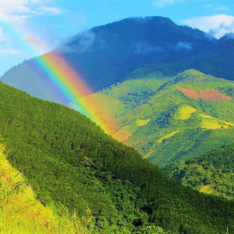
A rainbow in the mountains between Sin Ho & Muong Lai on Road QL12, Lai Chau Province

The flooded valley of the Black River, near Muong Lai at the junction of Road QL12

Road QL4H meandering through the mountains between Cha Cang & Muong Nhe, Dien Bien Province

Road QL12 echoing the course of the Nam Na River, seen from the road to Muong Te

Vietnamese visitors relax next to a tank on top of A1 Hill, site of the battle for Dien Bien Phu, spring 1954

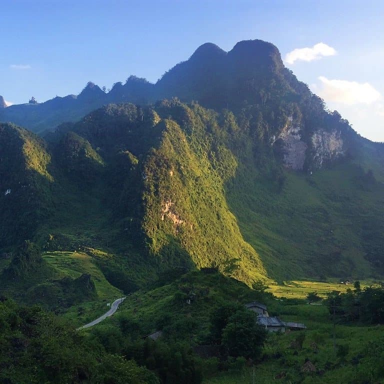
The spectacular Road DT128 winds up the mountains between Lai Chau & Sin Ho

My parents passing through a landslide on the Black River road between Muong Te & Muong Lay

The wide, muddy Black River, swelled by the construction of hydroelectric dams near Muong Lay

The empty & remote road between Phong Tho & Muong Te, passing through endless mountain scenery

Extreme switchbacks on the road to Muong Te, making progress slow but the views are stunning

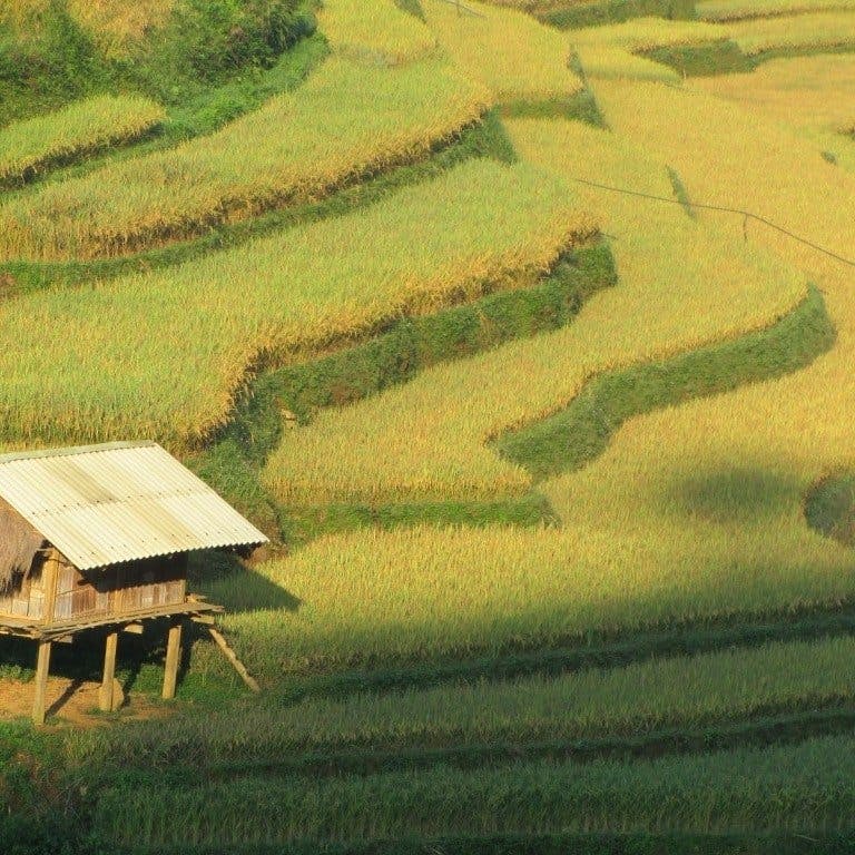
Terraced rice fields on the mountainsides descending Road DT128 from Sin Ho to Muong Lay

The new road cut into the hillside along the Black River valley, between Muong Te & Muong Lay

A passing shower in the mountains & forests of remote Dien Bien Province

The famous O Quy Ho Pass curling around the mountains from Sapa to Lai Chau

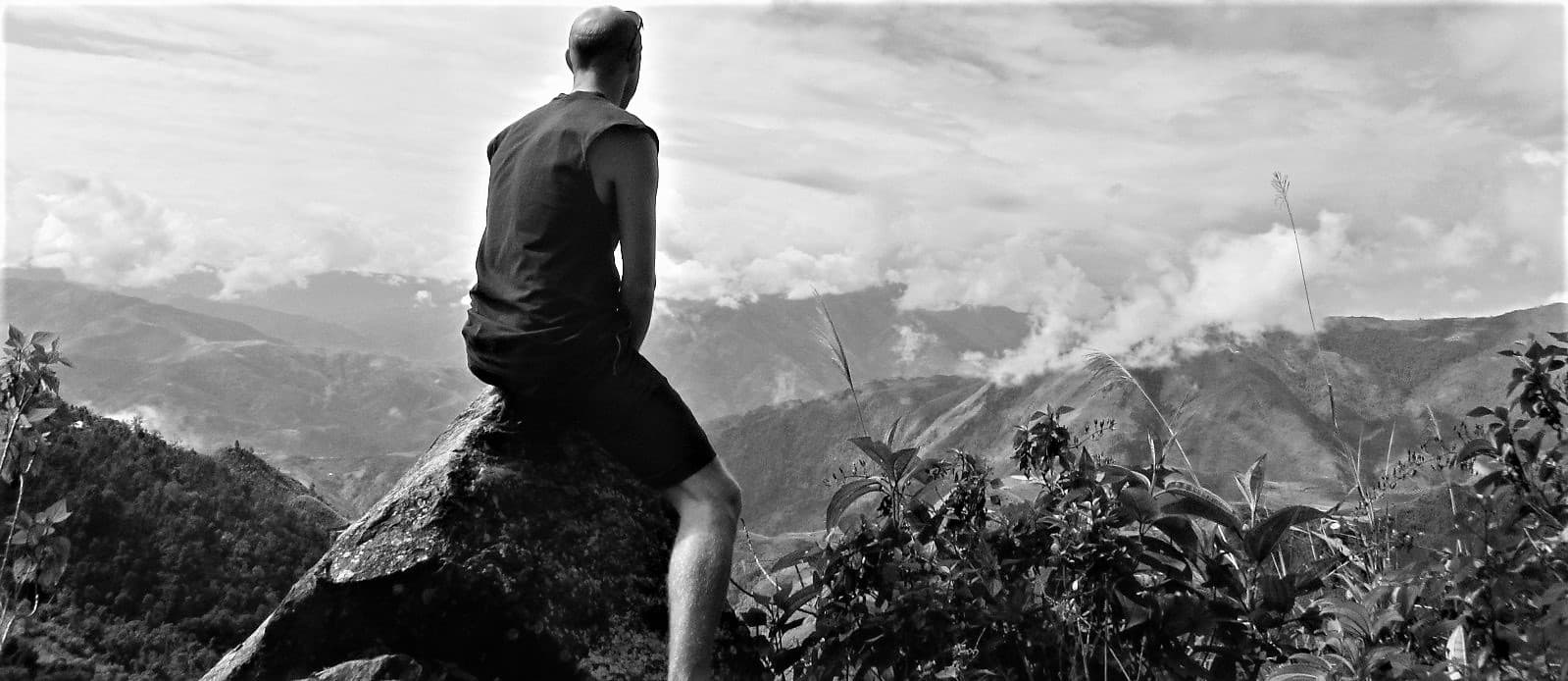
Sitting atop a mountain & taking in the views across the landscapes of Dien Bien & Lai Chau provinces

A remote hamlet on the hillside between Sin Ho & Moung Lay, Lai Chau Province
[Back Top]

Hi Tom! Thanks so much for this amazing guide. Im hoping to travel parts of this in April!
I notice there’s no section by section guide for this one like there is with the others, but i swear there used to be? Did you take it down to edit or.something?
Thanks!
Hi Ben,
Good to hear you’re going to give this route a go. Remember to refer to other people’s recent updates in the comments below.
No, there’s never been a section by section guide to this route. Perhaps you’re thinking of the Extreme North Loop.
Best,
Tom
First of all a monumental Thanks to Tom and everyone who contributed on this guide! You guys are da true MVP! 🙏🏼
I just come from an epic 15 days motorbike trip from the Northwest (September-October 2025), which I mostly planned on the basis of this guide here. I did almost all of the roads as described on this guide, but at the beginning I added Pu Luong, Mai Chau and Son La areas before I continued in Dien Bien Phu.
This was basically my route (designated on where I slept):
Hanoi
Thành Lâm (one of the many villages in Pu Luong Nature Reserve)
Mai Chau
Sông Mã (south of Son La, alternative route to Dien Bien Phu)
Dien Bien Phu
Mường Chà
Mường Nhé
Mường Tè
Sìn Hồ
Lai Châu
Sa Pa
Y Tý
Võ Lao / Văn Bàn (had to stay there because typhoon Bualoi)
Mậu A (again stayed there only because typhoon)
Phú Thọ (again only because typhoon)
Hanoi
————
At this point I want to share some hopefully valulable to information to you and other fellow travellers (as of September-October 2025), and only concerning the places on this guide:
– An alternative way to reach Dien Bien Phu from the east (instead of the busy main road QL6/AH13 from Son La) is to go slightly more south via Sông Mã. While it is a officially a border region, the hotel there (AN NHI HOTEL) let me sleep there without issues. Just show your regular passport and visa. This is an interesting alternative for people who already know the busy QL6. I basically took an obscure but scenic road DT103, then a scenic mountain pass road (marked “118” in Google Maps) to the junction place Nà Ớt, then to Sông Mã. From Sông Mã you basically ride along DT115 and then DT130 all the way to Dien Bien Phu. Beware that on the first third or so there is a lot of construction going on, but it’s not too bad. There is an awesome sidetrip over a backroad ( you can make from Pá Nặm to Trống Sư A / Phì Nhừ which has phenomenal sights (and even an ancient Buddhist stupa in Là Nuông). From then on it’s easy but a scenic sailing to Dien Bien Phu.
– Now concerning the famous extreme northwestern “sensitive” region: The road DT131 starting from Mường Chà to Mường Nhé town these days is really well developed – almost no construction, bad parts, nothing. It was a smooth ride and cruise to Mường Nhé. On the way there were no police checkpoints or whatsoever. In Mường Nhé proper there are enough guesthouses to choose from, again I had no problems. It was more funny that the receptionist was really surprised to see a western foreigner checking in and was so shy about it. In Mường Nhé there are also enough restaurants, shops, mechanics and all – it didn’t make an impression of a super remote town, but more like a regular Vietnamese medium-sized town. On the way to Mường Nhé there is also a recommended viewpoint called “Điểm săn mây Nậm Kè” where locals go cloud chasing in the morning. I thought it was a nice mini sidetrip.
– I then attempted to obtain the bragging rights of going to A Pa Chải, the famous tri-border junction at the extreme northwest between Vietnam, China and Laos. Now this is a bit more sensitive! Personally, I didn’t bother going to the police department in Mường Nhé town to get permission or anything, because I wanted to take the chance to just try it (since everything was just good so far). The famous road from Mường Nhé to A Pa Chải is really well developed and built, no bad parts whatsoever, and even no traffic on it, nothing. You almost could race to the border without issues and it felt very quick going there. After about 1 hour I then finally arrived at the actual border post at A Pa Chải, and I noticed on the horizon that the government built a brand-new flagtower on the actual border point, similar to the Lung Cu flagtower in Ha Giang region. Then there is a barrier and some border guards barracks at the end of the main road. Then a border guard guy came and said to me, that if I wanted to reach the tower, I should follow a literal dirt road to the left for about 6 kilometers and drive to the tower by myself.
So basically I started driving on this dirtroad, when suddenly another border guard officer whistled to me and pointed that I should get back. This big honcho explained to me in a friendly and nice manner (via Google Translate) that this whole area is a no-go for any foreigner and that I should please turn back. I asked him, if I should have gotten a permit first somewhere, but he didn’t really give any answer to that – just that I should turn back and go. He was also quite stubborn about that. So my take is: If you don’t have an actual special permit or something (which I still don’t know if it exists), it’s not really worth going to the actual border point as a foreigner. Also I thought that the landscape is not scenic either, but this is subjective. Maybe things may change in the future and this becomes a famous border point, but right now I’d say it’s not worth. At least I got a picture of myself in front of the barrier and barracks for the bragging rights. 😂
– Now as for the “invisible”, “sensitive territory” black road from Mường Nhé to Pắc Ma: It was no problem at all. There were 0 checkpoints, police or whatsoever. Also the quality of the road was really good and almost finished. Only at maybe two points or so there were very short constructions, maybe also due to the two big dam projects still going on, but really nothing dramatic. I personally found the road not too scenic or anything, it’s just noteworthy that there were very few houses or towns along this road. To me it seems that it’s only the two new dams that give this road a raison d’être… I noticed that in one village along the road there was some sort of barrier and a small house, which may be normally a police or border guard checkpoint or something like that. But I drove through at noon 12:30, and there was nobody there whatsoever. Just drive through it.
– When you arrive in Pắc Ma, and if you want to see a bit more of this extreme northwest region, I challenge you guys to continue northwards Ka Lăng. I drove to the village of Ka Lăng (marked Mé Gióng on Google Maps) to see a bit of that region just for fun, and I found the views really nice. Also the road was not too shabby, it was paved all the way to the village. I thought landscape-wise it’s more beautiful than most of the stuff before in Mường Nhé (again subjective). I didn’t drive further than the point in Mé Gióng, but I can imagine that driving further this road to Border Post No. 29 (basically the very northern tip) must be really beautiful. But from Ka Lăng it’s still at least 50km to the border post, so do this if you have lots of time. I’d love hearing from somebody driving this region! In general, my gut feeling told me that the region around Pắc Ma may have really interesting backroads and villages to visit – this is truly the OG adventurous Vietnam!
– But alas, I had to continue on the road along the Black River from Pắc Ma to Mường Tè. This part is really scenic and has lots of phenomenal views over the river, small fishing boats and whatnot. It almost felt like being in the Mekong region of Laos, radiating similar vibes. The road itself is really good, paved and perfect all the way. Again here, no checkpoints, controls or whatsoever. In Mường Tè, again, there are enough guesthouses and restaurants, again an average Vietnamese medium-sized town. The hotel (Muong Then Hotel) again asked for nothing special out of the oridinary. You see, this was a long day of driving: From Mường Nhé, a small sidetrip to A Pa Chải, continue to Pắc Ma, a small sidetrip to Ka Lăng, and then finished up in Mường Tè. If I could go back in time, I personally would skip A Pa Chải and do the other part north of Ka Lăng instead. This region seemed much more scenic than the corner in A Pa Chải, to be honest. But that’s just my taste and opinion.
– Then the part between Mường Tè to Sìn Hồ: I read online that the upper road from Mường Tè to Pa Tần is a nicer way to go than the lower DT127 – again my subjective opionion withou having seen the DT127. That upper road was really nice, it felt like a very long mountain pass road with good views and with few houses and towns from second half on. Again this one was in perfect condition and a bliss to drive. Then at Pa Tần I followed the QL12 south to Chà Nưa town, the starting point of famous DT128 road to Sin Ho. Right there at the junction was a construction sign warning drivers that only motorbikes are allowed to continue on the DT128, because one of the bridges on the DT128 is apparently on the brink of collapse. And indeed: I later encountered this bridge which indeed looked pretty bad! You can certainly drive on it with motorbikes, but I would be very nervous to drive something bigger on it. As you correctly described, the views on the DT128 are phenomenal – you will stop at many places to do pictures. Sadly, about the second half you will see A LOT of construction and dirt roads though. This very rough patch will almost continue without break until actual Sin Ho town. It’s not totally dirt and mud roads, but sometimes rocky and unpaved, and its definitely rough. But again, super scenic, with all these suddenly emerging limestone mountains on the plateau!
– In Sìn Hồ itself, there is sadly bad news: The legendary “Ba Sanh Homestay” recently closed its doors since the old boss lady deservedly retired. But if you still want to experience the traditional Dao herbal baths, there are other alternatives in Sin Ho town, for example the “Mẩy Thanh” herbal bath a bit further downtown. It may not be as rustic or authentic as “Ba Sanh Homestay”, but I guess the Dao herbal bath experience is similar. And if you already are in Sin Ho, you should absolutely not miss the opportunity of doing a small sidetrip to the village of “Sà Dề Phìn” to see the iconic “Đỉnh Cát Chùa Sì” viewpoint. The village is just about 5km southwest of Sin Ho, and 100% worth visiting IMO. You can drive all the way up the the viewpoint through a narrow paved road, and it’s really something out of this planet. On Google Maps you may see the road continuing at 22°17’36.6″N 103°13’46.6″E until the peak. Just do this.
– Then the rest of DT128 until Lai Chau is in perfect order and condition again. Nothing more to add here. Except that you guys should 100% do the northern sideloop described by Tom to the Dào San area. This sideloop was so worth it, one of my favorites on this trip hands down. For this sideloop, you don’t need to go all the way down to Lai Chau of course, you can take a small road north at 22°28’30.3″N 103°17’27.3″E. Then do the said sideloop and then continue to Lai Chau.
– In Lai Chau try to sleep at the lakeside – some very cool hotels and snail restaurants there. The nearby “Pu Sam Cap Caves” marked by Tom are also worth visiting (it’s about a 1-2 hours experience). If you are heading towards Sapa, absolutely go and visit “Tiên Sơn” Cave as well (some dude marked it as permanently closed in Google Maps, but it’s up and running). I also lovingly call it the “Slippers Cave” and I already visited 10 years ago. It’s still a super fun experience and you guys should do it too. The rest of the road to Sapa needs no comment as it’s pretty famous and well-documented.
– Now to the legendary Y Ty Loop – this really was something. For me this was the toughest, wildest but at the same time most awesome and scenic part of my trip. As described, you first need to drive to Muong Hum via DT155. At first the road good, but then sometime halfway to Muong Hum the road gets really rocky, partly muddy and there are also small river crossings which may be risky when there is a lot of rain or typhoons. Important: At the point 22°27’56.5″N 103°45’17.3″E the government is about to build an alternative road to Muong Hum, going a bit to the west and then continuing north. They also signaled this new road as going officially to Muong Hum. Because of this I took the decision to leave DT155 and take this road here to the left, since at first it looked paved and of good quality. But believe me, after about 20 minutes it becomes rough and rocky again, plus there is another river crossing later. 😂 Also, again this is a phantom road that is not visible on Google Maps, but on satellite only. 😂 It leads to a small hamlet at 22°27’44.9″N 103°44’01.0″E , and from there the way is again visible on Google Maps and you can continue north to Muong Hum. Warning: It is in actuality a paved, but very narrow pathway which meanders through duck farms and rice fields. This is really adventurous, but not the faint-hearted. The road is maybe 60% paved and 40% rocky, and after about 1 more hour you finally reach Muong Hum. Check out the market there. Now as far as I know, it is allowed to sleep in Muong Hum officially without a border permit, so you must make up your own mind if you want to sleep here or take your chances to sleep in Y Thy instead. I decided to take my chances and drive to Y Thy instead.
– The DT158 from Muong Hum to Y Ty really is something – it’s the most epic and breathtaking road I took so far I guess. It’s really something of a Tolkien book or similar. The condition I would describe as mostly OK. The pavement is not finished in the first third or so I would estimate, but it’s not super rocky or anything. It’s well manageable and drivable. Then it gets even better and the pavement gets finished too until Y Thy. I really needed to stop a lot of times for the views and pictures! In Y Thy itself, there are enough accomodations. But as mentioned, you officially need a permit to sleep there, and most of the accomodations know about that. The first hotel I tried plainly rejected me and told me, I should drive back to some sort of construction office that has bunk beds at 22°37’37.2″N 103°37’41.1″E where apparently it’s allowed to sleep without a permit. But after I tried at another accomodation next door, they were nice enough to call an immigration officer, and that officer said it was fine for me to stay. The accomodation with its dramatic views on the rice terraces was really good and I 100% would recommend to sleep there, if it wasn’t for that permit thing. My take is: You should take your own decision, weigh up your own risks and plan your own route if you either want to sleep in Muong Hum or Y Thy. Just be prepared that you may get rejected in Y Thy and need to drive back.
– The DT158 north of Y Ty is also in rough shape: I would estimate that at least one third of the whole road until the Red River is in construction, lots or rocky and muddy patches. Again dramatic views over the rice terraces! But one more tip: If you continue your way north on the DT158 towards the Chinese border and Red River, 100% pay a visit at the Lũng Pô border flagtower at the Chinese border (at 22°47’32.6″N 103°38’46.3″E). This point is accessible without any permits and the road there is really good and without any issues. On Google Maps the roads to there are all tangled up and not really visible. Just take the road along the river at 22°46’21.0″N 103°39’53.5″E and follow it for about 15 minutes or so. It’s almost like the flagtower in Lung Cu, and not many people come to visit here. A short but good sidetrip indeed, before you follow south to Lai Chau.
– From here on my trip basically finished, as I did most of the Northwestern Extreme Loop. I still wanted to do Mu Cang Chai and the “Dinosaur’s Back” on my way back to Hanoi, but the suddenly incoming Typhoon Bualoi threw a wrench into my plans. South of Lai Chau I suddenly got into it, which made going to the mountains again a bad plan and idea (landslides, floodings, etc.). I basically sticked along the Red River until Hanoi. At one point in the town of “Mậu A” this turned out to be a bad idea, because after I spent the night there I noticed that almost all roads leaving the town were cut off by floodings from the typhoon. 😂 There was one road left that still lead over the mountains to QL70, and that one was hit by a landslide too, that had to be excavated for about 2 hours. Luckily, me and most of the locals were unharmed by the whole typhoon thing, but it sure was an adventure of sorts. I then continued my way to Hanoi which luckily was only a bit wet but nothing dangerous anymore.
So my favorite experiences were definitely:
– The small backroads between Mai Chau to Dien Bien Phu (a lot of them!)
– The small backroads around Pac Ma (north to Ka Lang, then down along the river)
– DT128 towards and out of Sin Ho, and its surroundings
– The small sideloop to Dào San area – a hidden gem
– The ride to and out of Y Ty – I think this was the highlight of them all.
Sorry for the long write, I hope this helps other readers and riders. 👍🏼
Hi Manuel,
Thank you for the useful and valuable updates. I’m sure it will be a great help to other riders.
Best,
Tom
Hi Manuel, three of us are taking an SUV on the loop from sapa to Lai Chau and Sin Ho this weekend and I am wondering if you could be more specific about where the bridge is out for cars on DT128 please? Is it south of Sin Ho? Also you mentioned that Tom’s northern side loop is absolutely worth doing. Is that a days trip? Would it be feasible to go from Lai Chau down to Sin Ho and back up the same road if the bad bridge is south of Sin Ho? Thanks for your awesome comment above 👌🏽, Angie
Dear Angie, sorry if I’m late with replying, you must already be on your way. Yes, the damaged bridge is south of Sin Ho, on the DT128 between Chà Nưa and Sìn Hồ. I tried to look on Google Maps for the exact location, but I couldn’t find it, sorry. On both sides of the bridge there were barriers blocking large vehicles, and only a small gap is being left for motorbikes.
And yes, the northern side of DT128, from Lai Chau to Sin Ho, was in perfect order. That’s also the way how the bigger vehicles still come to Sin Ho. And you don’t have to go back on the very same DT128 to Lai Chau, you can do the alternative road via Vàng Bon which is also marked on this guide.
And as for the northern sideloop at Dào San area – I indeed loved it! The whole sideloop took me about 2-3 hours I’d estimate, starting from Nậm Cáy and ending up in Mường So. So I did this as a sidetrip when I drove from Sin Ho to Lai Chau. But it depends a bit how many times you stop for photos, also I think that it may take longer with a car than with a motorbike.
Again sorry if was too late with the reply, and hope you have a great time in VN, without any typhoons and landslides like me! 👍🏼
Thanks for your comprehensive reply. We have a car and driver and I asked him to check out the state of the bridge and then road but alas, he didn’t. So today we drove down to Chá Nua, only for him to see the sign and a local man told him the bridge collapsed a couple of days ago. So we turned around and had to go all the way back, missing the incredible scenery south of Sin Ho that we were so looking forward to. So disappointed
Hi Tom/All,
Gone from Hanoi-Lang Son-Cao Bang and done the Ban Gioc & China Border loop before heading to Bac Be via Bac Lao. We have then followed the 279 to Bac Quang and now Lao Caoi.
Fantastic routes, especially loved the China border crawl and the stretch from Bac Lao to Ba Be Lake. Will update findings on each route page, but for now, a question for any other recent riders.
Off to begin the Extreme NorthWest loop tomorrow and the last positive report of no issues on here is March 2024 on the black section. We are wondering if anyone has any other updates. We usually set off at 6:30AM so confident enough of finding a bed for the night on any of the other stretches.
Hi Roger,
Well, the comment from Stefano is only from a day or two ago.
In general, road conditions should be OK, unless there’s been a lot of rain, in which case landslides are likely.
The biggest issue most people have is staying overnight in that region, although most of the reports in 2025 have been quite positive about that, including emails that I’ve received.
So, if you’re planning to leave early, you should be able to complete that section in a day and therefore not need to overnight on that bit.
However, I would certainly encourage reading through the comments, because it’s still likely that you would be stopped if you encounter police during the ride, because this is a border region.
Best,
Tom
Hello Tom,
I drove today from Sin Ho to Muang Lay and when I arrived in Muang Lay around 1pm I went checking some hotels which were depressing and not clean, so at that point I decided to head towards Nam Nhun, which I reached around 3pm.
I went to see some some guesthouses, one was not to be found (Thuy Ahn Hotel) , then I went to one called Tre Nga Hotel. This one had an empty reception so I shout “hello” a couple of times and after 2 minutes a young lady came out of one room, looked at me with a bored face, and told me “no”. I am pretty sure the hotel was mostly available, I just had the feeling she didn’t want to give me a room. So I went to another guesthouse on the opposite side of the road , and I got the same treatment from the lady at the reception. Again “no”. At that point I started getting a bad feeling and also quite worried, because the only option was to drive to Muong Te to find more guesthouses… anyway, I tried my chance by visiting another guesthouse (Nha Nghi Phuong Huyen) and as was entering the building the lady told me “no”, doing some gestures as to tell me to go to another guesthouse… at that point I started getting really worried. I tried looking for more guesthouses at the other side of the village and found one where they were doing heavy renovation and the whole place looked messy, dusty and apparently closed. But to my surprise it was open and a lady accepted me, so I am writing to you now from this guesthouse (Nha Nghi Huy Huang) about my “misadventures”.
As I told you, I am pretty sure all those guesthouses that didn’t accept me were not full at all, so I am still asking myself why they didn’t accept me. The last and only time I experience something similar was in Y Ty, where just out of pure curiosity I asked if I could sleep there and they refused me. But in that case it was ok, as I was going to sleep in Sapa anyway that night.
I just hope in the next days on this remote Northwestern loop not to experience such rejections again…
I felt the urgence to write this message to warn other travelers coming on this path.
Sincerely,
Stefano
Hi Stefano,
Sorry to hear you had some trouble finding a place to stay, but I’m happy you found somewhere eventually.
Yes, staying overnight on this route can be an issue if you are a foreign rider, so it’s worth bearing that in mind and also checking some of the other comments below to learn about other riders’ experiences on this route.
Best,
Tom
Hi All,
Stumbled on this blog while exploring the possibilities of renting a Motobike in Dien Bien Phu and returning it at Lsi Chau. Could anyone give some leads? And tips ? Thank you .
Hi Hung,
For one way motorbike rental on that route you may find it hard. It’s probably best to try in Sapa, as that is a much more touristy area than either Dien Bien Phu or Lai Chau. You could also try contacting some of the reputable rental companies I mention on this page – perhaps they will be able to work something out. If not, then I would suggest that you just ride the full loop instead of one way.
Best,
Tom
Hi Tom,
Much appreciate your reply.
Yes I might just rent a motorbike in Sapa and son the full loop.
I did the Ha Giang loop in January and really enjoyed it. I am looking and hoping to find something similar mountain backdrop but more quite / remote experience.
Do you have any suggestions/ recommendations?
Take care .
Hung
Hi Hung,
Yes, there are lots of great loops in the northern mountains that are not crowded. Please browse my Northern Routes guides.
Best,
Tom
Hi Tom!
The last 2 days, we drove parts of this loop again. Here our findings:
Yesterday morning we left Dien Bien Phu and drove up to Pac Ma via Muong Lay and Muong Te. We spent the night at the only Na Nghi in Pac Ma. Lovely owner, good beds and great dinner and breakfast! The owner took our passports to the police station across the road. One hour later we got them back, all good! The next morning we drove from Pac Ma to Sin Ho via Muong Nhe and (again) Muong Lay. Almost all roads were sealed tarmac, no roadworks or landslides. Only the last bit before Sin Ho was under construction. Excellent driving! Also no border police seen.
Enjoy this marvelous part of Vietnam to y’all who are embarking on this loop!
Regards,
Martijn
Hi Martijn,
Thank you for your trip report. That is great news and very helpful to me and anyone else who might want to follow this route.
Thanks again, and I’m happy you enjoyed riding in this corner of Vietnam.
Best,
Tom
Thanks for your blog, Tom. I wouldn t have dared to take that route on my own were not for it.
I rented a mbike in Dien Bien and rode to Sin ho taking route 128 via Tan gao and Ho ho. From there to Muong te passing Lai chau. From there to Muong nhe via Pac ma and Pin Kho. I did no take the detour to the right to A pa chai border.
From muong nhe kept straight on to on to Mung cha and QL12 back to Dien bien phu.
I spend nights at Sin Ho and Muong the. Three days on the motorbike. Six to ten hours on the road. Too much. One more day would have been more like it.
Most of the time the road is good. Some stretches with works where one have to slow down, and intermitent passing where the machinery are working on landslides. Waiting time one hour in the worst case.
The route to Sin ho from south is STILL UNDER WORKS. Doable with care and taking plenty time (about 3 hours). Not advisable if one s not confident on mbike, lots of dust, mud, and very rough surfaces.
Zero permits needed and zero dealing with police
Impressive views and experience. There are petrol stations everywhre. I carried a reserve bottle of gasoline for extra peace of mind. There are places to sleep in every village but standards may be very low in the smallest hamlets. One should try to make it to somewhere “big” (i.e Sin ho, Muong the, Muong nhe…) for the night. Almost no one speaks english in the area. Gooogle translator is of much help.
Again, thanks Tom. If You want me to further elaborate on any matter just drop a line.
(I did not came across one single foreign tourist/traveler in the whole loop)
Muang Ngoi, november 12, 2024
Hi Victor,
Thank you for this useful trip report and road updates – it’s a great help to me and to other rider. It’s great that you were able to ride the entire route without any problems. I’m very happy you enjoyed it.
Best,
Tom
Cheers Tom, this blog is an invaluable resource and should be considered as the shining example for anyone trying to start a travel/destination blog.
I just returned to Hanoi after nine days exploring the Northwest on a Honda XR150. It’s unbelievable how many perfect, scenic, fun, and quiet roads the Northwest area has.
My itinerary was a bit all over the place but roughly speaking: Hanoi – Mai Chau – Dien Bien (food poisoning, oops.) – Sin Ho – Sapa (Ta Van) – Muong Te – Cha Cang (past Muong Nhe) – Son La – Hanoi
So the food poisoning and bad weather threw a bit of a wrench into the plan I never really had but all in all it was 1.800km of excellent, world-class roads in the past few days. My shoulder can testify to that.
On to the more useful stuff:
I had absolutely 0 (zero, cero, null) police / border patrol interactions on the entire trip. That includes driving the black route from Muong Te to Muong Nhe.
The road conditions are pretty ideal except for the southern approach into Sin Ho, as previously mentioned.
This area is incredible, however, be aware that poverty rates are 80-90% up here – I haven’t seen that mentioned anywhere. That means you’ll be lucky to find a single restaurant “open” past 7. Even then you may just get whatever is left over. English is pretty much 0; that sadly includes the kids on the side of the road that don’t even shout “hello” at you (ymmv, I couldn’t find good resources on how education is in this area). Just something I noticed that laid a bit heavy on my mind.
Adjust your expectations and it’ll be an unforgettable experience. Or in short: this isn’t ha giang.
Accommodation was solid all around – I stuck with hotels mentioned previously and didn’t pay more than 300k.
So all in all definitely go explore this area. It seems restrictions are loosening slowly but surely. Fwiw, a hostel owner in Dien Bien told me they’re working on a process to take foreigners to A Pa Chai (Frontier hostel! 10/10!)
Hi Richard,
Thank you for these important and useful updates on the route. It’s good to hear you rode it without any hindrances. Did you stay overnight anywhere on the black route? I think that is usually when people have problems.
Best,
Tom
Hello Tom,
Thank you for your wonderful guides! We’ve been using them for the past few days to explore the north.
We set out from Sa Pa, and then moved on to Sin Ho, and are currently in Dien Bien Phu. The scenery is all incredible and we’ve been very welcomed by a lovely homestay in Sin Ho called Villa de la Roseraie, and managed to get the last room in the Muong Thanh Grand hotel for last night – lots of festivities happening in the city right now.
At the time of travel, there are heavy roadworks and the road is in very bad shape if you leave Sa Pa through the villages (Cat Cat and Sin Chai), despite the harrowing start to the day, it was worth it, as those views were some of the most incredible — took us over 2 hours to do 9 km.
From west of Sa Pa to Sin Ho, the roads are great – no road works or landslides. However, leaving Sin Ho to continue south on the DT128, the next 30 km or so are under complete road works. It had rained heavily the night before, so we got quite muddy, but once we were free from that, it was smooth sailing, and incredible roads!
We’re off to do a portion of the Trans-Northern Belt this morning, with a stop planned just East of Than Uyen.
We’ve loved the market in Sin Ho, as we caught it the Sunday morning, and have enjoyed all of the animals along the side of the road!
Happy travels everyone!
Emily and David
Hi Emily & David,
Thank you for the useful updates. And I am very to happy to hear that you are enjoying your road trip in the big landscapes of the northwest. I hope you enjoy the next section too.
Best,
Tom
Hi Tom!
I’ve been reading and using your motorcycle guides for some time now and I decided to share my experiences on the extreme Northwest motorbike guide, specifically the black road on your map.
I rented a motorcycle in Dien Bien Phu on 16/12/2023 and decided to embark on your extreme Northwest motorcycle loop the next day. My plan was to drive the loop clockwise starting in DBP and ending there as well. Regarding your black line on the map, this would mean that I would drive to Muong Nhe on the first day, spend the night there, and then drive through Pac Ma and Muong Te onwards to Sin Ho the 2nd day.
As I started in DBP, I decided to inform about the permit with a local tour guide in DBP and with the government. The tour guide asked around for me and later told me that for travelling and spending a night in either Muong Nhe, Pac Ma and Muong Te there is no permit needed. Only if I wanted to go off the QL4H, I needed to have a permit (for Thu Lim, Ka Lang and A Pa Chai).
I wasn’t planning on going off the QL4H, so I felt okay driving without the permit, but I had some time left in DBP so curious as I was, I decided to see what the permit procedure looks like. I went to the Provincial Police station first, where the officer told me I had to go to the Immigration Office to apply for the permit. The Immigration Office can be found right across the airport, next to the gas station (Phòng Quản Lý Xuất Nhập Cảnh). The lady working there told me that if I wanted to get a permit, I needed to have a sponsor living in the border area (like a friend or family). I didn’t have a sponsor, but since I wouldn’t be driving off the QL4H anyway I didn’t mind not getting the permit.
Off I went the next day, towards Muong Nhe. About 40km before Muong Nhe, I got stopped by a police officer who asked for my document with the help of Google Translate. Not knowing what document he meant exactly, I handed him my International Driving Permit. He took a photo of my IDP and he said everything was okay and that I could continue my trip. This was the only police officer I came across that day. Also no border patrol seen.
In Muong Nhe I stayed at Nhà Nghỉ Bình Minh, a nice and clean guesthouse off the main road (Google Maps shows the wrong location though, you have to drive about 200m further on the main road and then to the right). Run by a sweet family, 250k for a private room. The hotel owners did not ask for a permit and even asked me if I wanted to drive to A Pa Chai so me being there and driving around all seemed fine.
The next day I drove to Pac Ma, onwards to Muong Te and finally to Sin Ho where I spent the night (what a gem!) The whole day, I did not see police or border patrol. The road from Muong Nhe to Pac Ma was overall in good condition, only a few patches of 1-2km each with some road work but passable in 2nd gear. Some other parts of the road showed some potholes but nothing that really slowed me down (I drove a manual 135cc scooter). Pac Ma to Muong Te road in perfect condition, a pleasure to drive on.
In short: In my case when I drove the ‘black route’ in December 2023: no permit needed if you stay on the QL4H and roads overall in good condition, only some patches with road work.
Hi Martin,
Thank you for sharing your experience on this route and for all the helpful updates. It’s really great to hear that you were able to overnight and ride the entire black route without hindrance. I hope this will be the case from now on – it would be great for riders to be able to enjoy that corner of the country and spread a bit of the tourist buck in the northwest to that isolated region.
Thanks again.
Best,
Tom
Thanks for the details Martin! Very helpful info! Me and some friends are planning a similar route in March, but we will go counter clockwise.
A question if you don’t mind: The black route doesn’t show a road on Google Maps between Pac Ma and Phi Chi, nor can I see any resemblance of a dirt road on Google Maps satellite view. Does the correct route go right out of Pac Ma going south and follow the river/black line? The reason I ask is because Google Maps shows another real road that runs through some small villages just to the east of the black line/river road (through Si Ne, Ban E Ma). I wanted to make sure we take the correct route heading south out of Pac Ma. Thanks!
Hi Matt,
Parts of that road (the black route) don’t show up on Google Maps because that region is considered ‘sensitive’. When you get to Pac Ma, you’ll either be able to see which road to take or you’ll need to ask a local for the way to Muong Nhe.
Best,
Tom
Hi,
I have a more general question but i add it here because it concerns the sensitive border areas which is mentioned here.
I found a list of the communes/districts that require a permit to go there. The list is actually quite extensive and also contains places such as Y Ty, Dong Van, Si Ma Cai, and even places in the Mekong delta, besides the places mentioned in this article. In fact a large part of QL12 even is theoretically passing through sensitive area. However, since most of the information is in Vietnamese it’s quite confusing on what are the rules. Anyone has more information on this?
More specifically:
– Is a permit needed only for spending the night or also for just passing? In the latter case it’s difficult to ride any of the northern loops probably
– Where to request permits? Normally i read in the province/district capitals but if riding from Sa Pa to Ha Giang for instance you’ll be passing sensitive areas on the way to Ha Giang.
– Anyone any idea on duration of a permit if received? I’m a cyclist myself so probably it will take me considerably longer than someone with a motorbike to pass from one main town to the next 🙂
Thanks!
Hi Maikel,
In general, it’s just border regions. Mostly the permit is required for staying over night, but sometimes, depending on how ‘sensitive’ a location is considered, it may also be required for passing through.
Permits are usually issued at the provincial capital people’s committee. It can take between 1-3 days, but in some cases, you simply can’t get a permit as a foreign visitor.
However, almost all the routes on my website do not require special permits to visit, so you are unlikely to have problems. Just avoid border areas and check comments for routes that go near borders.
If you are stopped by police, be polite, smile and do you best to explain the situation: in the majority of cases, police are kind and understanding.
Best,
Tom
7/6 Left Moung Te and headed to Muong Lay.
Interesting back story about this town as I found the place a bit odd. Basically nothing noteworthy at Moung Lay but the roads are wide but it seems sparsely populated.
From what I gathered this is the new Moung Lay as the original town is submerged after the dam was built to prevent flash floods.
Stayed a night at the Truc An Guesthouse for 200k.
It is on a hill and if you don’t have transport it is about 1km away from the town centre at the bridge. The hotel is kinda creepy as there were only a car and 2 bikes parked. Lol
Food wise nothing to shout out too.
In my opinion skip this town if you can.
Hi Brendon,
Yes, the town was flooded a decade ago and rebuilt higher up the valley.
Best,
Tom
This morning 6/6/23 left Sin Ho for Muong Te taking the DT128/QL12/Muong Te Pa Tan Road/DT127.
It was raining heavily from Sin Ho. The raod conditions on this route is good.
Staying at Khach San Hoang Lam for 250k and the room is superb. Their restaurant is just next door and they prepared stir fried beed noodles for me.
Tomorrow I head to Muong Lay and the weather forecast is heavy rain. Sigh….
I am NOT going to A Pa Chai since it is a sensitive area close to the Chinese border.
So far the closest I got to the Chinese border is at Lao Cai where I could see the Chinese city a few hundred metres away.
Hi Brendon,
Make sure you read the previous comments on this page: some people have also had difficulties staying the night in Muong Te, not just A Pa Chai and the rest of the black line route.
Best,
Tom
I was good at Muong Te. As I was checking out from the hotel and setting up the bags on the bike, there was a guy in dark green military uniform at the hotel. He seemed to be an officer and his uniform was pressed smart. He actually came over to talk to me and asked where I was from and whether the XR150 was running good. We communicated via Google Translate. I think he was picking up someone from the hotel. He shook my hand and as I left and waved me good bye.
Good to hear that.
Tom
Trip Report for 04/20-04/23:
I did a bit of a different route but included a lot of the stuff on here. Started in Thanh Hoa early morning on the 20th and got south of this route in a place called Pung Luong. Stayed at a really lovely homesty with Hmong people. The next day I continued up north on QL32 and joined the blue line through Lai Chau. Continued on the Blue Line on QL4 and joined the short red bit that continues into Phong Tho. From there I went all the way south on QL12 to Dien Bien Phu.
I don’t know if it’s this time of year or smoke from Laos, but the road was hot and smoky pretty much all the way from Lai Chau to Dien Bien Phu. Bring plenty of water, and maybe even a mask as certain parts of the road were hot and smoky, making it a tough day of riding. However, the views are incredible, QL12 pretty much follows a river mountain valley all the way from the northern border with China down to Dien Bien Phu.
The next day I took a bit of the green route on QL279 from Dien Bien Phu all the way to Mai Chau in Hoa Binh province, far off this route. Today I got back to Thanh Hoa, totalling a little over 1200 km. Wish I had more time to do all the bits on this route but it was a great taste of the northwest.
Thank you VC!
Hi Ryan,
Thank you for sharing your trip report around this route and beyond. It’s great to hear you enjoyed it. But, yes, much more time would be even better 🙂 I hope you get another chance sometime soon.
Best,
Tom
Hey, Tom. Currently towards the end of stitching together my own loop from all the routes you’ve posted (thank you, by the way!) & there is now permits required on different parts of the blue line sections, it seems. I was going to go to Ban Moi from Dien Bien Phu but was told by the hostel owner there that I needed a permit to even get close to there. He was with an American guiding a group tour a few villages before Ban Moi and they were forced to leave during the evening because of not having a permit to stay.
As of this moment I am Y TY & was just stopped by a border guard & questioned. Through an English speaking intermediary I was told I needed a permit from Lao Cai to be here but they’ll make an exception as long as I don’t go any farther north to china, stick inside the village area, and leave right away in the morning. They wouldn’t even let me choose my own accommodation. So, overall it appears that the ‘sensitive’ border areas requiring permits for foreigners seems to have broadened in recent times. The west has been amazing despite these restrictions though
Hi Rylee,
Thanks so much for these important and useful updates. I appreciate it and I’m sure they’ll also be useful to other readers and riders.
Yes, it does seem as though, post-pandemic, border regions are even more sensitive than previously.
Best,
Tom
Best,
Tom
Here’s my trip report: I came up here seeing your route as good to go and I checked into my hotel in Muong Nhe and then went for a little drive. Upon coming back I was told by the owner that the police had been by to check permits.
A bit later I went to the restaurant close by where I met some really good friends. They invited me to kareoke that night and then to join them in Pac Ma the following day.
Upon leaving the restaurant I was stopped by a police/border/who knows what agency and brought me back to my hotel close by. He told me I was in violation to be in Muong Nhe altogether and I couldn’t leave the hotel until the morning in which I had to leave the district entirely.
I didn’t even get to say goodbye the the great Vietnamese friends I met and I kept asking why, being a curious person, and all he kept saying is if you want to be here you need a permit from Dien Bien Phu.
Hi Geordi,
Thanks for sharing your experience on this route. Sorry to hear you had trouble riding here: it is common in this region to be stopped, questioned and even turned back by authorities. I suppose everyone has a different experience riding here. I think the best any rider can do at the moment in the Extreme Northwest is to come expecting and prepared for such circumstances, and be ready to turn back if told to. I know it’s frustrating, but they are only doing their job and it’s best to try to handle those encounters with patience and acceptance. The only other thing to do is to try to obtain the permit in Dien Bien Phu.
Best,
Tom
We are just coming back from Phong Thổ (->over Mount Te) -> Pac Ma (->over Mount Nhé) -> Cha Cang (so the black line on the map)
We asked at the police station in Muong Te how to obtain a permit for the tour. First they told us “report to hotel in Pac Ma”, then they told us we can also get it directly from the police station in Pac Ma.
We stayed at Nhà Hàng Hương Hộ (250k/night), directly opposite of the police station. The owner took our passports to register(?) us at the police station. We got them back in the morning. I don’t know if he did anything with our passports or just pretended to do so.
We Could drive to Muong Te without seeing any authorities the whole day.
So everyone seemed quite chilled.
Hi Till,
Thanks for your trip report.
To be clear: you rode to Muong Te to Muong Nhe on the black route without any problems or paperwork, is that correct?
Best,
Tom
Yes, correct. No sign of any controls there 🙂
And only letting the hotel manager in Pac Ma doing something with our passports.
That’s great news! Thanks.
Tom
Hi Tom, just discovered your journal. nice. We are riding (bicycle) some of S Vietnam / Mekong Delta in November but the north has a lot of attractions; when would be the best time for a bicycle tour in the far north avoiding the worst extremes of weather (heat, cold & rain) or can we only avoid two of the three? Regards Richard
Hi Richard,
Take a look at my Weather Guide for more information about this. Also see the first few paragraphs of any of my Northern Routes (including the one on this page above) where I mention the general best time of year to ride/visit.
Best,
Tom